
Street Plan Collection

"Exploring the Streets of Old London

Background imageStreet Plan Collection: Old Street Map of Bethnal Green and Hackney 1908

Old Street Map of Bethnal Green and Hackney 1908
Detailed colour Street Plan of London from 1908 covering the area around Bethnal Green and Hackney. The image has been remastered from Bartholomews Handy Atlas of London and Suburbs 1908

Background imageStreet Plan Collection: Old Street Map of The Isle of Dogs and River Thames at Greenwich 1908

Old Street Map of The Isle of Dogs and River Thames at Greenwich 1908
Detailed colour Street Plan of London from 1908 covering the area around The Isle of Dogs and The River Thames at Greenwich.The image has been remastered from Bartholomews Handy Atlas of London

Background imageStreet Plan Collection: The Village of Kineton, Warwickshire, 1885-1887, (1944). Creator: Unknown

The Village of Kineton, Warwickshire, 1885-1887, (1944). Creator: Unknown
The Village of Kineton, Warwickshire, 1885-1887, (1944). Map showing the market place, St Peters Church, Wesleyan chapel, the Steam Corn Mill, the Manor House and the River Dene

Background imageStreet Plan Collection: Sewer depths in the City of London, 1944 (colour litho)

Sewer depths in the City of London, 1944 (colour litho)
7201427 Sewer depths in the City of London, 1944 (colour litho) by English School, (20th century); Private Collection; (add.info.: Town planning survey showing sewer depths in the City of London)

Background imageStreet Plan Collection: Old Street Map of Kensington and Notting Hill 1908

Old Street Map of Kensington and Notting Hill 1908
Detailed colour Street Plan of London from 1908 covering the area around Kensington and Notting Hill. The image has been remastered from Bartholomews Handy Atlas of London and Suburbs 1908

Background imageStreet Plan Collection: Old Street Map of The Strand, West End and River Thames 1908

Old Street Map of The Strand, West End and River Thames 1908
Detailed colour Street Plan of London from 1908 covering the area around The Strand, The West End and the River Thames.The image has been remastered from Bartholomews Handy Atlas of London

Background imageStreet Plan Collection: Old Street Map of Hamstead, Holloway and Islington 1908

Old Street Map of Hamstead, Holloway and Islington 1908
Detailed colour Street Plan of London from 1908 covering the area around Hamstead, Holloway and Islington. The image has been remastered from Bartholomews Handy Atlas of London and Suburbs 1908

Background imageStreet Plan Collection: Brighthelmston, c1779, (1939)

Brighthelmston, c1779, (1939). From A History of the Royal Pavilion, Brighton, by Henry D. Roberts. [Country Life Limited, London, 1939]

Background imageStreet Plan Collection: Map of the Roman provinces of Gaul, Britannia and Germania (coloured engraving)

Map of the Roman provinces of Gaul, Britannia and Germania (coloured engraving)
7148263 Map of the Roman provinces of Gaul, Britannia and Germania (coloured engraving) by Kiepert, Heinrich (1818-99); Private Collection; (add.info.: Map of the Roman provinces of Gaul)

Background imageStreet Plan Collection: France Militaire par Regions de Corps d Armee (engraving)

France Militaire par Regions de Corps d Armee (engraving)
7158174 France Militaire par Regions de Corps d Armee (engraving) by French School, (19th century); Private Collection; (add.info.: France Militaire par Regions de Corps d Armee)

Background imageStreet Plan Collection: Narrow streets less than 30 feet wide, City of London, 1939 (colour litho)

Narrow streets less than 30 feet wide, City of London, 1939 (colour litho)
7201423 Narrow streets less than 30 feet wide, City of London, 1939 (colour litho) by English School, (20th century); Private Collection; (add.info)

Background imageStreet Plan Collection: London in 1888: The City Road, Finsbury Circus to the 'Angel'Islington (engraving)

London in 1888: The City Road, Finsbury Circus to the "Angel"Islington (engraving)
7188742 London in 1888: The City Road, Finsbury Circus to the " Angel" Islington (engraving) by English School, (19th century); Private Collection; (add.info.: The City Road)

Background imageStreet Plan Collection: London in 1888: Euston Road and Marylebone Road, Kings Cross to Paddington (engraving)

London in 1888: Euston Road and Marylebone Road, Kings Cross to Paddington (engraving)
7188740 London in 1888: Euston Road and Marylebone Road, Kings Cross to Paddington (engraving) by English School, (19th century); Private Collection; (add.info.: Euston Road and Marylebone Road)

Background imageStreet Plan Collection: London in 1888: Tottenham Court Road and Hampstead Road, to Camden Town (engraving)

London in 1888: Tottenham Court Road and Hampstead Road, to Camden Town (engraving)
7188738 London in 1888: Tottenham Court Road and Hampstead Road, to Camden Town (engraving) by English School, (19th century); Private Collection; (add.info.: Tottenham Court Road and Hampstead Road)

Background imageStreet Plan Collection: The Lair of the Law as Few Londoners Ever See It: The Temple and the Courts of Justice, c1935

The Lair of the Law as Few Londoners Ever See It: The Temple and the Courts of Justice, c1935. Aerial view of the Aldwych area in Westminster, London

Background imageStreet Plan Collection: Newcastle-on-Tyne, c20th Century. Artist: John Bartholomew

Newcastle-on-Tyne, c20th Century. Artist: John Bartholomew
Newcastle-on-Tyne, c20th Century. [John Bartholomew & Son, Edinburgh]

Background imageStreet Plan Collection: Burlington House, Piccadilly, early 18th century, (1908). Artist: Johannes Kip

Burlington House, Piccadilly, early 18th century, (1908). Artist: Johannes Kip
Burlington House, Piccadilly, early 18th century, (1908). The buildings today house the Royal Academy of Arts. A print from The Private Palaces of London by E Beresford Chancellor, (Kegan Paul)

Background imageStreet Plan Collection: Plan of New York, 1854. Creator: Unknown

Plan of New York, 1854. Creator: Unknown
Plan of New York, 1854. From "Cassell's Illustrated Family Paper; London Weekly 31 Dec 1853 to 30 Dec 1854"

Background imageStreet Plan Collection: Map of India during the reign of the Mughal Emperor Akbar, 16th Century (engraving)

Map of India during the reign of the Mughal Emperor Akbar, 16th Century (engraving)
7185032 Map of India during the reign of the Mughal Emperor Akbar, 16th Century (engraving) by Le Bon, Gustave (1841-1931); Private Collection; (add.info)

Background imageStreet Plan Collection: Old Street Map of Chelsea, Putney and River Thames 1908

Old Street Map of Chelsea, Putney and River Thames 1908
Detailed colour Street Plan of London from 1908 covering the area around Chelsea, Putney and the River Thames. The image has been remastered from Bartholomews Handy Atlas of London and Suburbs 1908

Background imageStreet Plan Collection: Old Street Map of London South and River Thames 1908

Old Street Map of London South and River Thames 1908
Detailed colour Street Plan of London from 1908. The street map features London South wiith the River Thames from Vauxhall Bridge to the London Docks and features Westminster

Background imageStreet Plan Collection: Old Street Map of Oxford Street, Holborn and Euston Road 1908

Old Street Map of Oxford Street, Holborn and Euston Road 1908
Detailed colour Street Plan of London from 1908 covering the area around Oxford Street, Holborn and Euston Road.The image has been remastered from Bartholomews Handy Atlas of London and Suburbs 1908

Background imageStreet Plan Collection: Old Street Map of Woolwich and Thames Docklands 1908

Old Street Map of Woolwich and Thames Docklands 1908
Detailed colour Street Plan of London from 1908 covering the area around Woolwich and the Thames Docklands.The image has been remastered from Bartholomews Handy Atlas of London and Suburbs 1908

Background imageStreet Plan Collection: Old Street Map of London Central, East End and River Thames 1908

Old Street Map of London Central, East End and River Thames 1908
Detailed colour Street Plan of London from 1908. The street map features London Central and the east End with the River Thames from Blackfriars Bridge to the London Docks

Background imageStreet Plan Collection: Commercial Intercourse of Nations (colour litho)

Commercial Intercourse of Nations (colour litho)
7169533 Commercial Intercourse of Nations (colour litho) by English School, (20th century); Private Collection; (add.info.: Commercial Intercourse of Nations)

Background imageStreet Plan Collection: Central Berlin, 1937 (colour litho)

Central Berlin, 1937 (colour litho)
1729647 Central Berlin, 1937 (colour litho) by German School, (20th century); (add.info.: Germany central Berlin 1937)

Background imageStreet Plan Collection: Map of the Paris World Fair, 1937 (litho)

Map of the Paris World Fair, 1937 (litho)
1729068 Map of the Paris World Fair, 1937 (litho) by French School, (20th century); (add.info.: Map of the world fair, Paris, 1937)

Background imageStreet Plan Collection: Jerusalem, leave B, Israel (engraving, 1572-1617)

Jerusalem, leave B, Israel (engraving, 1572-1617)
LRI4714746 Jerusalem, leave B, Israel (engraving, 1572-1617) by Braun, Georg (1541-1622) and Hogenberg, Franz (1535-90); Private Collection; (add.info.: Jerusalem, leave)

Background imageStreet Plan Collection: The land of Cocagne, ideal and imaginary country, 19th century (epinal print)

The land of Cocagne, ideal and imaginary country, 19th century (epinal print)
ELD4836011 The land of Cocagne, ideal and imaginary country, 19th century (epinal print) by French School, (19th century); Private Collection; (add.info.: The land of Cocagne)

Background imageStreet Plan Collection: Les Deux Sevres (Deux-Sevres, 79), Poitou Charentes (Poitou-Charentes) - France and its Colonies

Les Deux Sevres (Deux-Sevres, 79), Poitou Charentes (Poitou-Charentes) - France and its Colonies
XEE4144439 Les Deux Sevres (Deux-Sevres, 79), Poitou Charentes (Poitou-Charentes) - France and its Colonies. Atlas illustrates one hundred and five maps from the maps of the depot of war

Background imageStreet Plan Collection: Department of Allier (03), Auvergne - France and its Colonies. Atlas illustrates one hundred

Department of Allier (03), Auvergne - France and its Colonies. Atlas illustrates one hundred
XEE4144657 Department of Allier (03), Auvergne - France and its Colonies. Atlas illustrates one hundred and five maps from the maps of the depot of war, bridges and footwear and the Navy by M

Background imageStreet Plan Collection: Le Cantal (15), Auvergne - France and its Colonies. Atlas illustrates one hundred

Le Cantal (15), Auvergne - France and its Colonies. Atlas illustrates one hundred
XEE4144621 Le Cantal (15), Auvergne - France and its Colonies. Atlas illustrates one hundred and five maps from the maps of the depot of war, bridges and footwear and the Navy by M. VUILLEMIN. 1876

Background imageStreet Plan Collection: Corsica including South Corsica (2A) and Haute Corsica (2B) - France and its Colonies

Corsica including South Corsica (2A) and Haute Corsica (2B) - France and its Colonies
XEE4144608 Corsica including South Corsica (2A) and Haute Corsica (2B) - France and its Colonies. Atlas illustrates one hundred and five maps drawn from the maps of the depot of war

Background imageStreet Plan Collection: Le Gers (32), Midi-Pyrenees (Midi Pyrenees) - France and its Colonies. Atlas illustrates one hundred

Le Gers (32), Midi-Pyrenees (Midi Pyrenees) - France and its Colonies. Atlas illustrates one hundred
XEE4144568 Le Gers (32), Midi-Pyrenees (Midi Pyrenees) - France and its Colonies. Atlas illustrates one hundred and five maps from the maps of the depot of war

Background imageStreet Plan Collection: Le Morbihan (56), Brittany - France and its Colonies. Atlas illustrates one hundred

Le Morbihan (56), Brittany - France and its Colonies. Atlas illustrates one hundred
XEE4144496 Le Morbihan (56), Brittany - France and its Colonies. Atlas illustrates one hundred and five maps from the maps of the depot of war, bridges and footwear and the Navy by M. VUILLEMIN

Background imageStreet Plan Collection: La Nievre (58), Burgundy - France and its Colonies. Atlas illustrates one hundred

La Nievre (58), Burgundy - France and its Colonies. Atlas illustrates one hundred
XEE4144487 La Nievre (58), Burgundy - France and its Colonies. Atlas illustrates one hundred and five maps from the maps of the depot of war, bridges and footwear and the Navy by M. VUILLEMIN. 1876

Background imageStreet Plan Collection: Le Nord (59), Nord Pas De Calais (Nord-Pas-de-Calais) - France and its Colonies

Le Nord (59), Nord Pas De Calais (Nord-Pas-de-Calais) - France and its Colonies
XEE4144486 Le Nord (59), Nord Pas De Calais (Nord-Pas-de-Calais) - France and its Colonies. Atlas illustrates one hundred and five maps from the maps of the depot of war

Background imageStreet Plan Collection: Tarn (Tarn, 81), Midi-Pyrenees (Midi Pyrenees) - France and its Colonies

Tarn (Tarn, 81), Midi-Pyrenees (Midi Pyrenees) - France and its Colonies. Atlas illustrates one hundred
XEE4144429 Tarn (Tarn, 81), Midi-Pyrenees (Midi Pyrenees) - France and its Colonies. Atlas illustrates one hundred and five maps from the maps of the depot of war

Background imageStreet Plan Collection: La Vendee (85), Pays de la Loire, - France and its Colonies. Atlas illustrates one hundred

La Vendee (85), Pays de la Loire, - France and its Colonies. Atlas illustrates one hundred
XEE4144421 La Vendee (85), Pays de la Loire, - France and its Colonies. Atlas illustrates one hundred and five maps from the maps of the depot of war, bridges and footwear and the Navy by M

Background imageStreet Plan Collection: Map of the city of Paris in 1876. - France and its Colonies. Atlas illustrates one hundred

Map of the city of Paris in 1876. - France and its Colonies. Atlas illustrates one hundred
XEE4144404 Map of the city of Paris in 1876. - France and its Colonies. Atlas illustrates one hundred and five maps drawn from the maps of the depot of war, bridges and footwear and the Navy by M

Background imageStreet Plan Collection: Map of the Roman Empire (coloured engraving)

Map of the Roman Empire (coloured engraving)
7148266 Map of the Roman Empire (coloured engraving) by Kiepert, Heinrich (1818-99); Private Collection; (add.info.: Map of the Roman Empire)

Background imageStreet Plan Collection: Maps showing the extent of realms of the known World in ancient times (coloured engraving)

Maps showing the extent of realms of the known World in ancient times (coloured engraving)
7148245 Maps showing the extent of realms of the known World in ancient times (coloured engraving) by Kiepert, Heinrich (1818-99); Private Collection; (add.info)

Background imageStreet Plan Collection: Map of the Caribbean Sea by Christophe Plantin, 1588

Map of the Caribbean Sea by Christophe Plantin, 1588
AIS5350385 Map of the Caribbean Sea by Christophe Plantin, 1588 by Plantin, Christophe (1414 or 1420-1589); Biblioteca Universidad, Salamanca

Background imageStreet Plan Collection: The city of Paris as it was in the future of Philippe Auguste in 1180. - France and its Colonies

The city of Paris as it was in the future of Philippe Auguste in 1180. - France and its Colonies
XEE4144408 The city of Paris as it was in the future of Philippe Auguste in 1180. - France and its Colonies. Atlas illustrates one hundred and five maps from the maps of the depot of war

Background imageStreet Plan Collection: Africa Francaise, Senegal - France and its Colonies. Atlas illustrates one hundred

Africa Francaise, Senegal - France and its Colonies. Atlas illustrates one hundred
XEE4144393 Africa Francaise, Senegal - France and its Colonies. Atlas illustrates one hundred and five maps from the maps of the depot of war, bridges and footwear and the Navy by M. VUILLEMIN. 1876

Background imageStreet Plan Collection: Map of Acadia (Canada) c. 1760 (engraving)

Map of Acadia (Canada) c. 1760 (engraving)
1721743 Map of Acadia (Canada) c. 1760 (engraving) by French School, (19th century); (add.info.: Map of Acadia (Canada) c. 1760, engraving)

Background imageStreet Plan Collection: Map of South America, in Universa ac Navigabilis Totius Terrarum Orbis Descriptio 1559

Map of South America, in Universa ac Navigabilis Totius Terrarum Orbis Descriptio 1559 (colour manuscript)
AIS5334419 Map of South America, in Universa ac Navigabilis Totius Terrarum Orbis Descriptio 1559 (colour manuscript) by Homem, Andre (16th century); Bibliotheque Nationale, Paris

Background imageStreet Plan Collection: Vision (litho)

Vision (litho)
7150306 Vision (litho) by Barrett, Oswald Charles (BATT) (1892-1945); Private Collection; (add.info.: Vision. Illustration from How Should We Rebuild London)


For sale as Licensed Images

Choose your image, Select your licence and Download the media

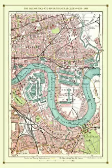
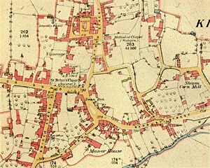
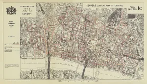
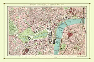
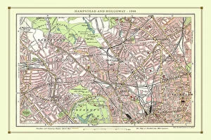
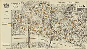
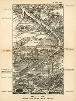
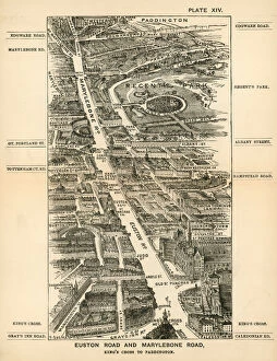
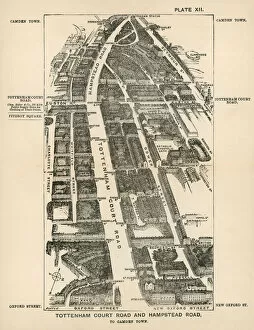
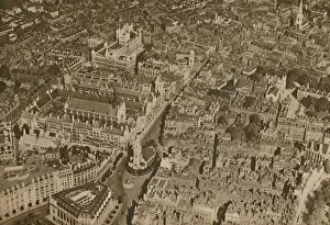
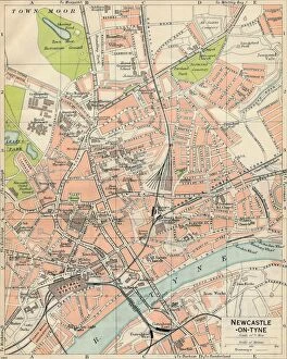
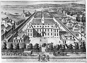
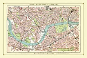
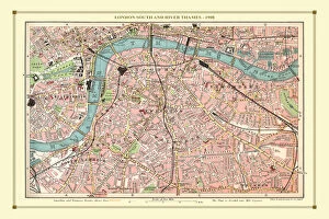
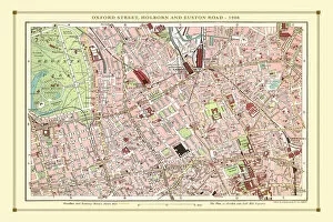
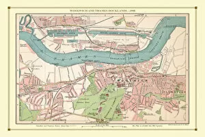
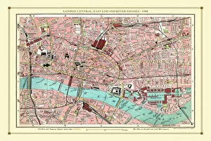
"Exploring the Streets of Old London: A Glimpse into the City's Past" Step back in time with these fascinating street plans that offer a captivating glimpse into the history of London. Delve into the past with an old street map of Bethnal Green and Hackney from 1908, revealing the intricate layout of these vibrant neighborhoods. Travel further east to The Isle of Dogs and discover how it looked in 1908, as you navigate its streets alongside the majestic River Thames at Greenwich. Uncover a hidden gem in Warwickshire with a village plan of Kineton dating back to 1885-1887, showcasing its quaint charm through an unknown creator's artistic vision. Dive beneath the surface as you explore sewer depths in the City of London from 1944, presented vividly through a colorful lithograph that reveals this crucial infrastructure. Journey northwards to Hamstead, Holloway, and Islington using an old street map from 1908; witness how these areas have evolved over time while retaining their unique character. Immerse yourself in grandeur as you traverse The Strand and West End on an exquisite street map from 1908; marvel at its architectural splendor while tracing your steps along the River Thames. Transport yourself to Victorian-era London with engravings depicting iconic routes such as Finsbury Circus to "Angel" Islington via City Road (1888), Euston Road to Paddington via Marylebone Road (1888), and Tottenham Court Road to Camden Town via Hampstead Road (1888). Admire Burlington House on Piccadilly through Johannes Kip's early 18th-century artwork (1908); get lost in its timeless beauty amidst one of London's most prestigious locations.