Home > Arts > Artists > O > Abraham Ortelius
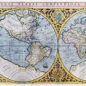
A Map of Great Britain, 1587 (hand coloured engraving)
")
![]()
Wall Art and Photo Gifts from Fine Art Finder
A Map of Great Britain, 1587 (hand coloured engraving)
985972 A Map of Great Britain, 1587 (hand coloured engraving) by Ortelius, Abraham (1527-98); Private Collection; (add.info.: A Map of Great Britain. Angliae, Scotiae et Hiberniae, Sive Britannicar: Insvlarvm Descriptio. Theatre de L Univers contenant les cartes de tout le monde. Abraham Ortelius (1527-98). Hand coloured engraving. published, Anvers, 1587.); Photo eChristies Images; Flemish, out of copyright
Media ID 22638730
© Christie's Images / Bridgeman Images
1580s Abraham Ortelius Artist Belgian Belgian Art Belgian Artist Eire Geographic Hand Colored Hand Coloring Hand Coloured Hand Colouring Hand Tinted Handcolored Late Sixteenth Century Navigational Equipment Ortelius Prints 1587
FEATURES IN THESE COLLECTIONS
> Arts
> Artists
> O
> Abraham Ortelius
> Arts
> Artists
> Related Images
> Europe
> Belgium
> Related Images
> Europe
> Related Images
> Europe
> Republic of Ireland
> Maps
> Europe
> United Kingdom
> Maps
> Europe
> United Kingdom
> Related Images
> Fine Art Finder
> Artists
> Abraham Ortelius
> Fine Art Finder
> Artists
> Frederick Polydor Nodder
> Fine Art Finder
> Temp Classification
> Maps and Charts
> Abraham Ortelius
EDITORS COMMENTS
This print showcases a hand-coloured engraving of "A Map of Great Britain, 1587" by Abraham Ortelius. The intricate details and vibrant hues bring this historical cartographic masterpiece to life. Published in Antwerp in 1587, the map is part of Ortelius' renowned work "Theatre de L Univers contenant les cartes de tout le monde" which encompasses maps from around the world. With its close-up view, we can appreciate the meticulous craftsmanship that went into creating this piece. Every contour and coastline of England, Scotland, and Ireland is delicately engraved and then carefully hand-tinted with an array of colors. This technique adds depth and richness to the map, making it visually striking even after centuries have passed. As we explore this late sixteenth-century representation of the British Isles, we are transported back in time to an era when navigational equipment was still evolving. The map not only serves as a geographic reference but also provides insight into how people perceived their surroundings during that period. Abraham Ortelius, a Belgian artist known for his exceptional cartography skills, demonstrates his mastery once again through this remarkable creation. His attention to detail and commitment to accuracy make this print a testament to his talent. Whether you are fascinated by history or simply appreciate fine artistry, this print offers a glimpse into Great Britain's past while showcasing the enduring beauty of Ortelius' work.
MADE IN THE USA
Safe Shipping with 30 Day Money Back Guarantee
FREE PERSONALISATION*
We are proud to offer a range of customisation features including Personalised Captions, Color Filters and Picture Zoom Tools
SECURE PAYMENTS
We happily accept a wide range of payment options so you can pay for the things you need in the way that is most convenient for you
* Options may vary by product and licensing agreement. Zoomed Pictures can be adjusted in the Cart.