Home > Africa > Algeria > Maps
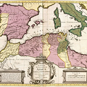
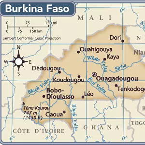
Map of Barbaria (Morocco, Algeria, Tunisia, Libya), Nigritude (Mali, Burkina Faso
, Nigritude (Mali, Burkina Faso")
![]()
Wall Art and Photo Gifts from Fine Art Finder
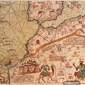
Map of Barbaria (Morocco, Algeria, Tunisia, Libya), Nigritude (Mali, Burkina Faso
LRI4706870 Map of Barbaria (Morocco, Algeria, Tunisia, Libya), Nigritude (Mali, Burkina Faso, Niger) and Guinee (Senegal, Guinea, Sierra Leone, Liberia, Ivory Coast, Ghana, Togo, Benin, Nigeria) (etching, 1730) by Delisle, Guillaume (1675-1726); Private Collection; (add.info.: Map of Barbaria (Cotes des Barbaresques ou Berberie: Morocco, Algeria, Tunisia, Libya) of Nigritude (Mali, Burkina Faso, Niger) and Guinee (Senegal, Guinee, Sierra Leone, Liberia, CA'te d Ivoire, Ghana, Togo, Benin, Nigeria) - Strong water extracted from the " Atlas Nouveau containing all parts of the world" 1730 de Guillaume de L Isle (1675-1726)); Luisa Ricciarini; French, out of copyright
Media ID 22278668
© Luisa Ricciarini / Bridgeman Images
Algeria Algeria Algerian Algerian Algerians Algerie Atlas Book Benin Geographical Map Ghana Guinee Ivory Coast Libya Libyan Maghreb Maghrebi Maghrebian Maghrebin Maghrebine Mali Moroccan Morocco Niger Senegal Senegalese Tunisia Tunisian Arab Civilization Burkina Faso Mauritanian Sudan
FEATURES IN THESE COLLECTIONS
> Africa
> Burkina Faso
> Maps
> Fine Art Finder
> Artists
> Guillaume Delisle
EDITORS COMMENTS
The print captures a fascinating historical map titled "Map of Barbaria (Morocco, Algeria, Tunisia, Libya), Nigritude (Mali, Burkina Faso, Niger) and Guinee (Senegal, Guinea, Sierra Leone, Liberia, Ivory Coast, Ghana, Togo, Benin Nigeria)" created by Guillaume Delisle in 1730. This intricate etching showcases the geographical boundaries of North African regions during the 18th century. Delisle's masterpiece provides a comprehensive view of the Maghreb region including Morocco, Algeria, Tunisia, and Libya. The map also encompasses Nigritude which includes Mali, Burkina Faso, and Niger as well as Guinee consisting of Senegal, Ghana, Ivory Coast, Liberia, Sierra Leone, Togo, Benin, and Nigeria. This rare map is extracted from Delisle's renowned work "Atlas Nouveau containing all parts of the world". It offers valuable insights into Arab civilization and Sudanese history during that era. The detailed engravings depict rivers, mountains, cities, and other significant landmarks across these diverse territories. Luisa Ricciarini has skillfully captured this piece from a private collection, enabling us to appreciate its beauty and historical significance. As we gaze upon this remarkable artwork, it transports us back in time to an era when cartography was instrumental in understanding and exploring new lands. With its rich colors and precise detailing, this print serves as a visual gateway to explore the cultural heritage and complex dynamics that shaped these regions centuries ago. It reminds us of the importance of preserving our past while embracing our ever-evolving present.
MADE IN THE USA
Safe Shipping with 30 Day Money Back Guarantee
FREE PERSONALISATION*
We are proud to offer a range of customisation features including Personalised Captions, Color Filters and Picture Zoom Tools
SECURE PAYMENTS
We happily accept a wide range of payment options so you can pay for the things you need in the way that is most convenient for you
* Options may vary by product and licensing agreement. Zoomed Pictures can be adjusted in the Cart.