
Maps Collection
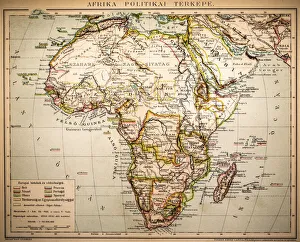
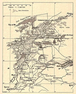
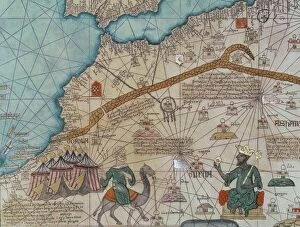
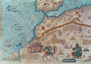
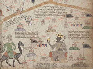
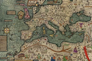
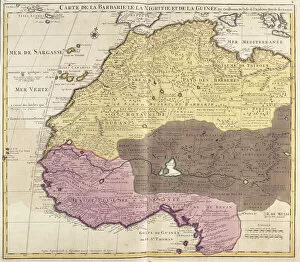
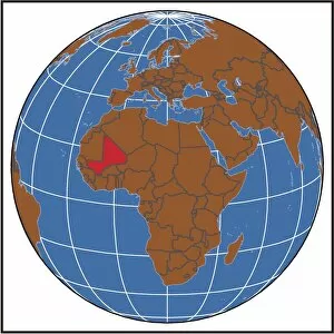
Mali is a landlocked country in West Africa, bordered by Algeria, Niger, Burkina Faso, Cote d'Ivoire, Guinea, Senegal and Mauritania
Choose a picture from our Maps Collection for your Wall Art and Photo Gifts
24 items
All Professionally Made to Order for Quick Shipping
-
Maps Collection
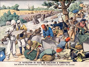
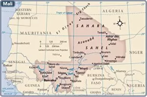
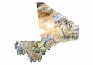
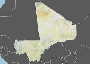
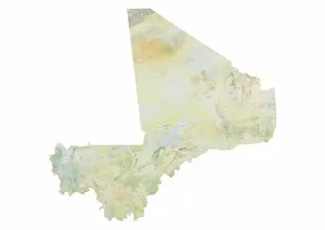
Mali is a landlocked country in West Africa, bordered by Algeria, Niger, Burkina Faso, Cote d'Ivoire, Guinea, Senegal and Mauritania. It covers an area of 1.24 million square kilometers and has a population of over 18 million people. The capital city is Bamako. Mali is one of the poorest countries in the world with an economy largely based on agriculture and livestock production. The terrain consists mostly of savanna plains with rolling hills in the north and flat plains in the south; there are also some mountains in the northeast region near Mopti. The major rivers are Niger River which flows through Mali from east to west; Senegal River which forms part of its western border; Bani River which flows from southwest to northeast; and Bougouriba River which runs along its southern border with Guinea.
+
Our beautiful pictures are available as Framed Prints, Photos, Wall Art and Photo Gifts
The Maps of Mali Africa collection from Media Storehouse is a stunning assortment of wall art and framed prints that showcase the beauty and diversity of the African country. Our collection features an array of maps, ranging from antique to modern, depicting various regions and landmarks in Mali. These maps are not only visually appealing but also informative, providing insights into the geography, history, and culture of this fascinating nation. Each print in the Maps of Mali Africa collection is carefully crafted using high-quality materials to ensure longevity and durability. Customers can choose from a variety of sizes and framing options to suit their individual preferences. Whether you're looking for a unique piece to decorate your home or office or seeking inspiration for your next adventure in West Africa, our collection has something for everyone. The Maps of Mali Africa collection is a must-see for anyone interested in exploring the rich heritage and natural wonders of this captivating country.
+
What are Maps of Mali Africa art prints?
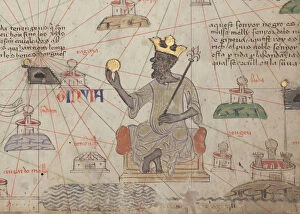
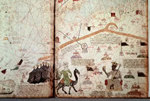
Maps of Mali Africa art prints are a collection of high-quality, visually stunning maps that showcase the geography and topography of Mali. These prints feature intricate details such as rivers, mountains, cities, and landmarks, making them perfect for those who want to learn more about this beautiful country or simply appreciate its natural beauty. The Maps of Mali Africa art prints come in a variety of sizes and styles to suit any decor. Whether you're looking for a large canvas print to hang on your living room wall or a smaller framed print for your office desk, there's something here for everyone. These art prints are made using only the highest quality materials and printing techniques to ensure that they look great for years to come. They make excellent gifts for anyone who loves travel or has an interest in African culture. If you're looking for beautiful and informative artwork that celebrates the beauty of Mali's landscape, then Maps of Mali Africa art prints are definitely worth checking out.
+
What Maps of Mali Africa art prints can I buy from Media Storehouse?
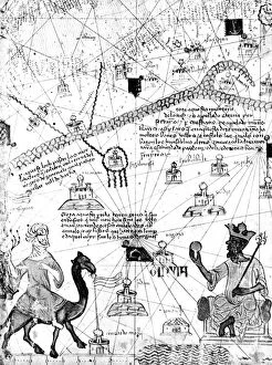
We offer a wide range of Maps of Mali Africa art prints that are perfect for anyone who loves African culture and history. These maps showcase the various regions, cities, and landmarks in Mali, including Timbuktu, Bamako, and the Niger River. You can choose from different styles such as vintage or modern designs to suit your personal taste. The Maps of Mali Africa art prints available at Media Storehouse come in various sizes and formats such as posters or canvas prints. They are printed on high-quality materials using advanced printing techniques to ensure that they look stunning on any wall. Whether you're looking for a unique piece of artwork to decorate your home or office space, or you want to give someone a thoughtful gift that celebrates their love for African culture, we have got you covered with its vast collection of Maps of Mali Africa art prints.
+
How do I buy Maps of Mali Africa art prints?
To buy Maps of Mali Africa art prints, you can visit our online marketplace. We offer a wide range of high-quality art prints that are perfect for decorating your home or office space. You can browse through our collection of Maps of Mali Africa art prints and choose the one that best suits your taste and style. Once you have selected the print, you can add it to your cart and proceed to checkout. At this point, you will be prompted to provide your shipping details and payment information. Once your order has been processed, Media Storehouse will ship the print directly to your doorstep. Their maps are printed on premium quality paper using state-of-the-art printing technology which ensures that every detail is captured perfectly. Whether you're looking for a gift for someone special or simply want to decorate your own space with beautiful artwork, we have got you covered.
+
How much do Maps of Mali Africa art prints cost?
We offer a wide range of Maps of Mali Africa art prints at various price points. The cost of these prints depends on several factors such as the size, material, and framing options. Our you can choose from different sizes ranging from small to large formats to suit their preferences and budget. We also offer various materials for our Maps of Mali Africa art prints including high-quality paper and canvas. Customers may opt for unframed or framed options depending on their preference. Our prices are competitive and reflect the quality of our products. We take pride in offering affordable yet premium quality art prints that capture the beauty and essence of Mali's geography. Our Maps of Mali Africa art prints are an excellent investment for individuals who appreciate fine art and want to add a touch of elegance to their living spaces while showcasing their love for this beautiful African country.
+
How will my Maps of Mali Africa art prints be delivered to me?
We take great care in delivering your Maps of Mali Africa art prints to you. We use high-quality packaging materials to ensure that your artwork arrives safely and undamaged. Your print will be carefully rolled and placed inside a sturdy tube for protection during transit. We work with trusted delivery partners who offer reliable shipping services worldwide. Once your order is dispatched, you will receive an email confirmation with tracking information so that you can monitor the progress of your shipment. Please note that our standard delivery service does not include any framing or mounting options. However, we do offer a range of framing options which can be selected at checkout for an additional fee. Whether you're purchasing art prints as a gift or for yourself, rest assured that we'll handle the delivery process with utmost professionalism and care.