Home > North America > Puerto Rico > Maps
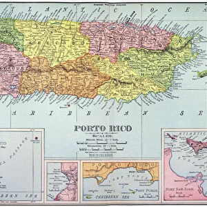
18th century map, Central America and Gulf of Mexico

![]()
Wall Art and Photo Gifts from Fine Art Finder
18th century map, Central America and Gulf of Mexico
5322624 18th century map, Central America and Gulf of Mexico.; (add.info.: 18th century map of Central America and the Gulf of Mexico engraved by Balthasar Ruyter.)
Media ID 38514292
© Bridgeman Images
Archival Archive Central America Cuba Florida Geographical Gulf Of Mexico Hispaniola Islands Jamaica Puerto Rico Venezuela
FEATURES IN THESE COLLECTIONS
> Fine Art Finder
> Artists
> Hans Memling
> Maps and Charts
> Early Maps
> North America
> Cuba
> Maps
> North America
> Cuba
> Related Images
> North America
> Jamaica
> Maps
> North America
> Jamaica
> Related Images
> North America
> Mexico
> Maps
> North America
> Mexico
> Related Images
> North America
> Puerto Rico
> Maps
> North America
> Puerto Rico
> Related Images
EDITORS COMMENTS
Transport yourself back in time with this stunning 18th century map of Central America and the Gulf of Mexico. Engraved by Balthasar Ruyter, this historical piece showcases the intricate details of the Americas, including Cuba, Jamaica, Florida, Puerto Rico, Venezuela, Hispaniola and more.
The vibrant colors and precise illustrations make this archival map a true work of art. From the lush greenery to the deep blue waters of the Gulf of Mexico, every aspect is meticulously captured in this engraving.
As you study each island and coastline depicted on this map, you can't help but feel a sense of wonder at how much has changed over the centuries. This piece serves as a reminder of our rich geographical history and how far we have come since those early explorations.
Whether you are a history buff or simply appreciate fine art, this 18th century map is sure to captivate your imagination. Hang it in your home or office to add a touch of historical charm to any space.
Let yourself be transported back to an era when exploration was at its peak and discover the beauty and complexity of Central America and the Gulf of Mexico through the eyes of Balthasar Ruyter.
MADE IN THE USA
Safe Shipping with 30 Day Money Back Guarantee
FREE PERSONALISATION*
We are proud to offer a range of customisation features including Personalised Captions, Color Filters and Picture Zoom Tools
SECURE PAYMENTS
We happily accept a wide range of payment options so you can pay for the things you need in the way that is most convenient for you
* Options may vary by product and licensing agreement. Zoomed Pictures can be adjusted in the Cart.