Home > Europe > United Kingdom > England > London > Sport > Polo
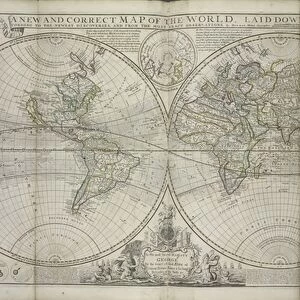
Chart of the Gulf of Mexico and Caribbean islands, 1742 (manuscript)
")
![]()
Wall Art and Photo Gifts from Fine Art Finder
Chart of the Gulf of Mexico and Caribbean islands, 1742 (manuscript)
7339545 Chart of the Gulf of Mexico and Caribbean islands, 1742 (manuscript) by Polo, Miol (18th century); 8x107 cm; National Maritime Museum, London, UK; (add.info.: Creator: Miol Polo); © National Maritime Museum, Greenwich, London
Media ID 38339700
© © National Maritime Museum, Greenwich, London / Bridgeman Images
Caribbean Isles Mexicans Mexico Mexican 18e Siecle 18th Century 18th Centuries
FEATURES IN THESE COLLECTIONS
> Europe
> United Kingdom
> England
> London
> Boroughs
> Greenwich
> Europe
> United Kingdom
> England
> London
> Museums
> Greenwich Heritage Centre
> Europe
> United Kingdom
> England
> London
> Museums
> National Maritime Museum
> Europe
> United Kingdom
> England
> London
> Sport
> Polo
> Europe
> United Kingdom
> England
> London
> Towns
> Greenwich
> Europe
> United Kingdom
> Heritage Sites
> Maritime Greenwich
> Europe
> United Kingdom
> Maps
> Fine Art Finder
> Artists
> Hermann Moll
> Maps and Charts
> Early Maps
> North America
> Mexico
> Maps
EDITORS COMMENTS
This stunning print showcases a Chart of the Gulf of Mexico and Caribbean islands from 1742, meticulously crafted by the talented cartographer Miol Polo. The intricate details and vibrant colors bring to life the beauty and complexity of this region during the 18th century.
As you gaze upon this historical manuscript, you can almost feel yourself transported back in time to an era of exploration and discovery. The carefully drawn coastlines, islands, and sea routes provide a fascinating glimpse into the navigational challenges faced by sailors centuries ago.
The rich hues used in this map add depth and character to each island depicted, making them stand out against the azure waters of the Gulf. From Cuba to Jamaica, each landmass is meticulously labeled with its name in elegant script, giving us a sense of the importance placed on accurate cartography during this period.
This print serves as a reminder of both the artistry and scientific precision required in creating maps before modern technology made navigation easier. It is a testament to human ingenuity and curiosity about our world that continues to inspire awe today.
Displayed proudly at the National Maritime Museum in London, this Chart of the Gulf of Mexico and Caribbean islands is not just a piece of history but also a work of art that captures our imagination.
MADE IN THE USA
Safe Shipping with 30 Day Money Back Guarantee
FREE PERSONALISATION*
We are proud to offer a range of customisation features including Personalised Captions, Color Filters and Picture Zoom Tools
SECURE PAYMENTS
We happily accept a wide range of payment options so you can pay for the things you need in the way that is most convenient for you
* Options may vary by product and licensing agreement. Zoomed Pictures can be adjusted in the Cart.