Home > Animals > Insects > Hemiptera > Black Scale
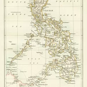
South China Sea, 1757 (engraving)
")
![]()
Wall Art and Photo Gifts from Fine Art Finder
South China Sea, 1757 (engraving)
7339394 South China Sea, 1757 (engraving) by Spanish School, (18th century); 31.5x42 cm; National Maritime Museum, London, UK; (add.info.: Creator: Pedro Manuel de Arandia; Laur. Atlas engraver
Single sheet. Engr. Scale: [ca.1:70 000]. Cartographic Note: North at 172 degrees. Ungraduated. Soundings. Scale in French miles. Additional Places: Batac, Luzon. Inscribed Plano del puerto de Cajayagan q comunmente llaman Palapa, cito en la Isla de Leyte a la pte Orient.l de S.Bernardino, q mando delinear, y esculpir el M.I.S. Presid. Gov. y Cap.n Gen.l delas Islas Philipinas D. Pedro Manuel de Arandia.'); © National Maritime Museum, Greenwich, London
Media ID 38408976
© © National Maritime Museum, Greenwich, London / Bridgeman Images
Chineze Filipino Philippines Phillippine South East Asia Asiae Chineses
FEATURES IN THESE COLLECTIONS
> Animals
> Insects
> Hemiptera
> Black Scale
> Arts
> Artists
> S
> Spanish School
> Asia
> Philippines
> Maps
> Asia
> Philippines
> Related Images
> Europe
> United Kingdom
> England
> London
> Boroughs
> Greenwich
> Europe
> United Kingdom
> England
> London
> Museums
> Greenwich Heritage Centre
> Fine Art Finder
> Artists
> James Cook
> Fine Art Finder
> Artists
> Spanish School (after)
EDITORS COMMENTS
This stunning engraving of the South China Sea from 1757 offers a glimpse into the intricate cartography of the time. Created by Spanish School artist Pedro Manuel de Arandia, this detailed map showcases the port of Cajayagan on the island of Leyte in the Philippines. The inscription reveals that it was commissioned by Governor and Captain General D. Pedro Manuel de Arandia himself.
The print captures not only geographical details but also historical significance, as it provides insight into navigation and exploration during the 18th century. With soundings marked and a scale in French miles, this map served as a vital tool for sailors navigating through these waters.
The engraving measures 31.5x42 cm and is housed at the National Maritime Museum in London, UK. It is a testament to both artistic skill and scientific precision, showcasing how art and cartography intersected in creating valuable navigational aids.
As we gaze upon this piece, we are transported back in time to an era when mapping uncharted territories was both an art form and a necessity for maritime travel. It stands as a reminder of our enduring fascination with exploring new horizons across the vast expanse of oceans like the South China Sea.
MADE IN THE USA
Safe Shipping with 30 Day Money Back Guarantee
FREE PERSONALISATION*
We are proud to offer a range of customisation features including Personalised Captions, Color Filters and Picture Zoom Tools
SECURE PAYMENTS
We happily accept a wide range of payment options so you can pay for the things you need in the way that is most convenient for you
* Options may vary by product and licensing agreement. Zoomed Pictures can be adjusted in the Cart.