Home > Arts > Artists > B > Willem Blaeu
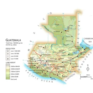
Geography map: representation of Central America with Honduras, Guatemala and the Yucatan Peninsula from an Atlas by Willem Janszoon Blaeu (1571-1638), approximately 1630. Biblioteca Angelica, Rome
, approximately 1630. Biblioteca Angelica, Rome")
![]()
Wall Art and Photo Gifts from Fine Art Finder
Geography map: representation of Central America with Honduras, Guatemala and the Yucatan Peninsula from an Atlas by Willem Janszoon Blaeu (1571-1638), approximately 1630. Biblioteca Angelica, Rome
VEN5030327 Geography map: representation of Central America with Honduras, Guatemala and the Yucatan Peninsula from an Atlas by Willem Janszoon Blaeu (1571-1638), approximately 1630. Biblioteca Angelica, Rome; (add.info.: Geography map: representation of Central America with Honduras, Guatemala and the Yucatan Peninsula from an Atlas by Willem Janszoon Blaeu (1571-1638), approximately 1630. Biblioteca Angelica, Rome); Photo © Marco Ravenna
Media ID 38274438
© Photo © Marco Ravenna / Bridgeman Images
17eme Siecle Amerique (continent) Amerique Centrale Amerique Du Nord Carte Geographique Central America Etats Unis Geographical Map Geographie Guatemala Honduras Stockravenna
FEATURES IN THESE COLLECTIONS
> Arts
> Artists
> B
> Willem Blaeu
> Europe
> Italy
> Emilia-Romagna
> Ravenna
> Fine Art Finder
> Artists
> Marcantonio Bassetti
> North America
> Guatemala
> Maps
> North America
> Guatemala
> Related Images
> North America
> Honduras
> Maps
> North America
> Honduras
> Related Images
EDITORS COMMENTS
This stunning print captures a detailed representation of Central America, specifically highlighting Honduras, Guatemala, and the Yucatan Peninsula. Created by Willem Janszoon Blaeu in approximately 1630, this map is a true work of art that showcases the intricate geography of the region during that time period.
The vibrant colors and precise details bring this historical map to life, offering viewers a glimpse into the past and how these countries were perceived centuries ago. The craftsmanship and attention to detail in Blaeu's work are truly remarkable, showcasing his skill as a cartographer.
Displayed in the Biblioteca Angelica in Rome, this map is not only a valuable historical document but also a beautiful piece of artwork. The fine lines and intricate patterns draw viewers in, inviting them to explore every corner of Central America as it was known in the 17th century.
Photographed by Marco Ravenna with precision and care, this print captures every nuance of Blaeu's original creation. It serves as a reminder of the importance of preserving our history through art and provides us with an opportunity to appreciate the beauty found within geographical maps like this one.
MADE IN THE USA
Safe Shipping with 30 Day Money Back Guarantee
FREE PERSONALISATION*
We are proud to offer a range of customisation features including Personalised Captions, Color Filters and Picture Zoom Tools
SECURE PAYMENTS
We happily accept a wide range of payment options so you can pay for the things you need in the way that is most convenient for you
* Options may vary by product and licensing agreement. Zoomed Pictures can be adjusted in the Cart.