Home > North America > Martinique > Maps
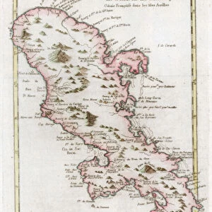
Map of the island of Martinique, the island of Saintes and the island of Marie Galante in

![]()
Wall Art and Photo Gifts from Fine Art Finder
Map of the island of Martinique, the island of Saintes and the island of Marie Galante in
JLJ4687642 Map of the island of Martinique, the island of Saintes and the island of Marie Galante in the West Indies. Engraving of the 19th century Chartres, Musee des Beaux Arts by French School, (19th century); Musee des Beaux-Arts, Chartres, France; (add.info.: Map of the island of Martinique, the island of Saintes and the island of Marie Galante in the West Indies. Engraving of the 19th century Chartres, Musee des Beaux Arts); Photo ePhoto Josse; French, out of copyright
Media ID 23324028
© Josse / Bridgeman Images
Caribbean Central America Dom Tom Martinican Martinique Geographical Map
FEATURES IN THESE COLLECTIONS
> Fine Art Finder
> Artists
> French School
> Fine Art Finder
> Artists
> Mesopotamian
> Maps and Charts
> Related Images
> North America
> Martinique
> Maps
> North America
> Martinique
> Related Images
EDITORS COMMENTS
This 19th-century engraving showcases a detailed map of the island of Martinique, along with the neighboring islands of Saintes and Marie Galante in the West Indies. The intricate lines and precise details on this geographical map offer a glimpse into the colonial era and highlight the historical significance of these Caribbean islands. Displayed at Chartres' Musee des Beaux Arts, this print captures the essence of French exploration during that time period. The artist's skillful craftsmanship is evident in every stroke, bringing to life the lush landscapes, winding coastlines, and vibrant towns that make up these tropical paradises. The Map of Martinique serves as a window into both past and present. It not only provides valuable insights into early cartography but also sheds light on the complex history of colonization in this region. From its American connections to its position within Central America, Martinique has played an integral role in shaping Caribbean culture. As you gaze upon this remarkable piece, allow yourself to be transported back in time – envisioning sailors navigating through uncharted waters or settlers establishing new communities amidst breathtaking natural beauty. This print from Fine Art Finder allows us to appreciate not only the artistic mastery behind it but also invites contemplation about our shared human history across continents and oceans.
MADE IN THE USA
Safe Shipping with 30 Day Money Back Guarantee
FREE PERSONALISATION*
We are proud to offer a range of customisation features including Personalised Captions, Color Filters and Picture Zoom Tools
SECURE PAYMENTS
We happily accept a wide range of payment options so you can pay for the things you need in the way that is most convenient for you
* Options may vary by product and licensing agreement. Zoomed Pictures can be adjusted in the Cart.