Home > Europe > Netherlands > Maps
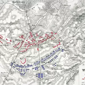
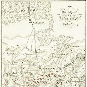
Map of the Netherlands and Belgium, around 1870 - Lithograph 19th century - Map of the Netherlands and Belgium, 1870s - Color lithograph

![]()
Wall Art and Photo Gifts from Fine Art Finder
Map of the Netherlands and Belgium, around 1870 - Lithograph 19th century - Map of the Netherlands and Belgium, 1870s - Color lithograph
NWI4872346 Map of the Netherlands and Belgium, around 1870 - Lithograph 19th century - Map of the Netherlands and Belgium, 1870s - Color lithograph; (add.info.: Map of the Netherlands and Belgium, around 1870 - Lithograph 19th century - Map of the Netherlands and Belgium, 1870s - Color lithograph); Photo © North Wind Pictures
Media ID 38335620
© Photo © North Wind Pictures / Bridgeman Images
Belgians Belgium Belgian Dutch Netherlands Geographical Map Hollander Hollanders Netherland Netherlands Holland Dutch The Netherland
FEATURES IN THESE COLLECTIONS
> Europe
> Belgium
> Related Images
> Europe
> Netherlands
> Maps
> Fine Art Finder
> Artists
> Spanish School (after)
> Maps and Charts
> Early Maps
> Maps and Charts
> Netherlands
EDITORS COMMENTS
This stunning lithograph from the 19th century showcases a detailed map of the Netherlands and Belgium, dating back to around 1870. The intricate lines and vibrant colors bring this historical piece to life, offering a glimpse into the geographical landscape of these European countries during that time period.
The map is filled with fascinating details, from the names of cities and towns to rivers and borders. It serves as a valuable historical document, providing insight into the political and cultural boundaries of the region in the late 19th century.
The color lithograph technique used to create this map adds an artistic flair to what could have been a simple cartographic representation. The hues chosen for each area help differentiate between regions and make it easier for viewers to distinguish between different parts of the map.
Whether you are a history buff, geography enthusiast, or simply appreciate fine art, this Map of the Netherlands and Belgium print is sure to captivate your attention. Display it proudly in your home or office as a conversation starter and reminder of days gone by in these beautiful European countries.
MADE IN THE USA
Safe Shipping with 30 Day Money Back Guarantee
FREE PERSONALISATION*
We are proud to offer a range of customisation features including Personalised Captions, Color Filters and Picture Zoom Tools
SECURE PAYMENTS
We happily accept a wide range of payment options so you can pay for the things you need in the way that is most convenient for you
* Options may vary by product and licensing agreement. Zoomed Pictures can be adjusted in the Cart.