Home > North America > Haiti > Maps
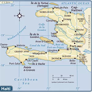
Map of the Caribbean Sea with the island of Cuba, Jamaica, Haiti, Central America (detail of the Panama Canal) and North South America, beginning of the 20th century
 and North South America, beginning of the 20th century")
![]()
Wall Art and Photo Gifts from Fine Art Finder
Map of the Caribbean Sea with the island of Cuba, Jamaica, Haiti, Central America (detail of the Panama Canal) and North South America, beginning of the 20th century
1761635 Map of the Caribbean Sea with the island of Cuba, Jamaica, Haiti, Central America (detail of the Panama Canal) and North South America, beginning of the 20th century; (add.info.: Map of the Caribbean Sea with the island of Cuba, Jamaica, Haiti, Central America (detail of the Panama Canal) and North South America, beginning of the 20th century); Photo: Tallandier
Media ID 38314474
© Photo: Tallandier / Bridgeman Images
Amerique Du Sud South America Caribbean Cuba
FEATURES IN THESE COLLECTIONS
> Fine Art Finder
> Artists
> Unknown photographer
> Maps and Charts
> Early Maps
> North America
> Cuba
> Maps
> North America
> Cuba
> Related Images
> North America
> Haiti
> Maps
> North America
> Haiti
> Related Images
> North America
> Jamaica
> Maps
> North America
> Jamaica
> Related Images
> North America
> Panama
> Maps
> North America
> Panama
> Related Images
EDITORS COMMENTS
This stunning print captures a detailed map of the Caribbean Sea at the beginning of the 20th century. The intricate design showcases the islands of Cuba, Jamaica, and Haiti, as well as Central America with a close-up view of the Panama Canal. North and South America are also depicted in this historical piece.
The level of detail in this map is truly remarkable, showcasing the geographical features of each region with precision. From the coastlines to mountain ranges, every aspect has been carefully illustrated to provide an accurate representation of these countries.
As you study this map, you can't help but be transported back in time to an era when exploration and discovery were at their peak. The lines on the paper seem to tell a story of adventure and intrigue, inviting you to delve deeper into the history of these lands.
Whether you have a personal connection to any of these regions or simply appreciate fine cartography, this print is sure to captivate your imagination. It serves as both a beautiful piece of art and a valuable historical document that sheds light on our past.
MADE IN THE USA
Safe Shipping with 30 Day Money Back Guarantee
FREE PERSONALISATION*
We are proud to offer a range of customisation features including Personalised Captions, Color Filters and Picture Zoom Tools
SECURE PAYMENTS
We happily accept a wide range of payment options so you can pay for the things you need in the way that is most convenient for you
* Options may vary by product and licensing agreement. Zoomed Pictures can be adjusted in the Cart.