Home > North America > El Salvador > Maps
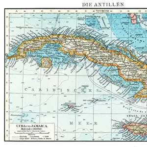
Map showing the course of Christopher Columbus from Guanahani to Cuba in 1492. From the book Life of Christopher Columbus by Clements R. Markham published 1892

![]()
Wall Art and Photo Gifts from Fine Art Finder
Map showing the course of Christopher Columbus from Guanahani to Cuba in 1492. From the book Life of Christopher Columbus by Clements R. Markham published 1892
2915328 Map showing the course of Christopher Columbus from Guanahani to Cuba in 1492. From the book Life of Christopher Columbus by Clements R. Markham published 1892.; Photo © Hilary Morgan
Media ID 38249536
© Photo © Hilary Morgan / Bridgeman Images
1492 Chart Christopher Colon Columbus Columbus Christopher (1451 1506) Course Cristobal Cristoval Cuba Geographical Mapmaking New World Salvador
FEATURES IN THESE COLLECTIONS
> Fine Art Finder
> Artists
> William (after) Orpen
> Maps and Charts
> Italy
> Maps and Charts
> World
> North America
> Cuba
> Maps
> North America
> Cuba
> Related Images
> North America
> El Salvador
> Maps
> North America
> El Salvador
> San Salvador
EDITORS COMMENTS
This print of a map showing the course of Christopher Columbus from Guanahani to Cuba in 1492 offers a glimpse into the historic journey that changed the course of world history. The intricate details and precise cartography depicted in this image highlight the skill and determination of Columbus as he navigated uncharted waters in search of a new route to Asia.
As we trace his path from Guanahani to Cuba, we are reminded of the courage and vision it took for Columbus to embark on such a daring expedition. The discovery of these new lands marked a turning point in geographical knowledge and opened up opportunities for exploration and colonization that would shape the future of our world.
Through this map, we can visualize the challenges faced by Columbus as he sailed across vast oceans, encountering unknown territories and forging connections with indigenous peoples along the way. Each line drawn represents not just a physical journey, but also a symbolic crossing into uncharted territory and new possibilities.
This print serves as a reminder of the enduring legacy of Christopher Columbus and his impact on global exploration. It invites us to reflect on how one man's bold vision forever altered our understanding of geography and reshaped our world.
MADE IN THE USA
Safe Shipping with 30 Day Money Back Guarantee
FREE PERSONALISATION*
We are proud to offer a range of customisation features including Personalised Captions, Color Filters and Picture Zoom Tools
SECURE PAYMENTS
We happily accept a wide range of payment options so you can pay for the things you need in the way that is most convenient for you
* Options may vary by product and licensing agreement. Zoomed Pictures can be adjusted in the Cart.