Home > Europe > Luxembourg > Maps
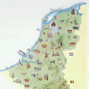
Map of Netherlands and Belgium, c.1900 (engraving)
")
![]()
Wall Art and Photo Gifts from Fine Art Finder
Map of Netherlands and Belgium, c.1900 (engraving)
532956 Map of Netherlands and Belgium, c.1900 (engraving); (add.info.: Map showing the historical boundaries of Netherlands, Belgium, Luxemburg, with insets of Amsterdam and Brussels, circa 1902, from the 10th edition of Encyclopaedia Britannica.); Encyclopaedia Britannica/UIG
Media ID 38406658
© Encyclopaedia Britannica/UIG / Bridgeman Images
1902 19th Century Style Amsterdam Boundary Brussels Geographical Border Guidance Illustration Technique Luxembourg Luxembourgers Luxemburg Meridian Navigational Equipment Old Fashioned Physical Geography The Past Western Script Belgians Belgium Belgian Dutch Netherlands Hollander Hollanders Netherland Netherlands Holland Dutch The Netherland
FEATURES IN THESE COLLECTIONS
> Europe
> Belgium
> Paintings
> Europe
> Belgium
> Related Images
> Europe
> Luxembourg
> Maps
> Europe
> Luxembourg
> Paintings
> Europe
> Luxembourg
> Posters
> Europe
> Luxembourg
> Related Images
> Europe
> Netherlands
> Amsterdam
> Fine Art Finder
> Temp Classification
EDITORS COMMENTS
This stunning engraving from the early 20th century showcases a detailed map of Netherlands and Belgium, complete with historical boundaries and insets of Amsterdam and Brussels. The intricate cartography highlights the geographical features of these European countries, including coastlines, boundaries, and meridians.
As we gaze upon this vintage print, we are transported back in time to an era of exploration and discovery. The old-fashioned style evokes a sense of nostalgia for a bygone age when maps were essential tools for navigation and understanding the world around us.
The fine details captured in this engraving speak to the craftsmanship and artistry involved in creating such intricate illustrations. From the delicate lines depicting borders to the elegant script labeling cities and regions, every element is meticulously rendered with precision.
This piece serves as a reminder of our rich history and how maps have played a crucial role in shaping our understanding of geography. It is a testament to human ingenuity and curiosity that continues to drive us forward in our quest for knowledge about the world we inhabit.
Overall, this Map of Netherlands and Belgium from c.1900 is not just a visual representation of two countries but also a window into the past that invites us to explore new horizons both literally on paper as well as metaphorically within ourselves.
MADE IN THE USA
Safe Shipping with 30 Day Money Back Guarantee
FREE PERSONALISATION*
We are proud to offer a range of customisation features including Personalised Captions, Color Filters and Picture Zoom Tools
SECURE PAYMENTS
We happily accept a wide range of payment options so you can pay for the things you need in the way that is most convenient for you
* Options may vary by product and licensing agreement. Zoomed Pictures can be adjusted in the Cart.