Fine Art Print > Africa > Uganda > Maps
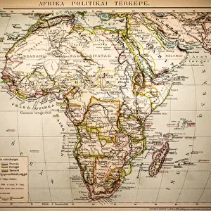
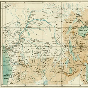
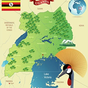
Fine Art Print : Map Of Central Africa Circa 1930. From The Modern Atlas Of The World Published Circa 1930


![]()
Fine Art Prints from Design Pics
Map Of Central Africa Circa 1930. From The Modern Atlas Of The World Published Circa 1930
Design Pics offers Distinctively Different Imagery representing over 1,500 contributors
Media ID 18193042
© Ken Welsh / Design Pics
Abyssinia Africa Belgian Central Colonies Congo Italian Kenya Madagascar Maps Northern South Southern Tanganyika Transvaal Uganda Wars West World Angola Bechuanaland Equatorial Possessions Protectorate Protectorates Rhodesia Somaliland
21"x14" (+3" Border) Fine Art Print
Step back in time with our exquisite Fine Art Print of the Map of Central Africa Circa 1930, taken from The Modern Atlas of the World published around 1930. This vintage map, created by renowned cartographer Ken Welsh, transports you to a bygone era with its intricate details and authentic design. Add a touch of historical charm to your home or office decor with this beautifully preserved piece of cartographic history. Each print is meticulously produced using high-quality materials and techniques to ensure a stunning and long-lasting display. Travel back in time and explore the world's rich history with our Fine Art Print collection from Media Storehouse.
21x14 image printed on 27x20 Fine Art Rag Paper with 3" (76mm) white border. Our Fine Art Prints are printed on 300gsm 100% acid free, PH neutral paper with archival properties. This printing method is used by museums and art collections to exhibit photographs and art reproductions.
Our fine art prints are high-quality prints made using a paper called Photo Rag. This 100% cotton rag fibre paper is known for its exceptional image sharpness, rich colors, and high level of detail, making it a popular choice for professional photographers and artists. Photo rag paper is our clear recommendation for a fine art paper print. If you can afford to spend more on a higher quality paper, then Photo Rag is our clear recommendation for a fine art paper print.
Estimated Image Size (if not cropped) is 53.3cm x 35.5cm (21" x 14")
Estimated Product Size is 68.6cm x 50.8cm (27" x 20")
These are individually made so all sizes are approximate
Artwork printed orientated as per the preview above, with landscape (horizontal) orientation to match the source image.
FEATURES IN THESE COLLECTIONS
> Africa
> Angola
> Related Images
> Africa
> Kenya
> Related Images
> Africa
> Madagascar
> Maps
> Africa
> Madagascar
> Related Images
> Africa
> South Africa
> Maps
> Africa
> South Africa
> Related Images
> Africa
> Uganda
> Related Images
EDITORS COMMENTS
This print showcases a Map of Central Africa circa 1930, taken from The Modern Atlas of the World published around the same time. The map provides a fascinating glimpse into the geopolitical landscape of this region during that era. The intricate details on the map highlight various European possessions and colonies in Central Africa, including French territories, Italian colonies, Belgian Equatorial regions, and British protectorates such as Uganda and Kenya. It also features prominent African countries like Angola, Abyssinia (modern-day Ethiopia), Madagascar, Congo, Tanganyika (now part of Tanzania), Rhodesia (present-day Zimbabwe), Bechuanaland (Botswana), and Somaliland. The historical significance of this map lies in its depiction of power struggles between European nations for control over African territories. It reflects an era marked by colonialism and conflicts as these powers sought to expand their influence across the continent. Ken Welsh's expertly captured print allows us to appreciate both the artistic beauty and historical value embedded within this vintage map. Whether you are a history enthusiast or simply intrigued by cartography, this piece serves as a window into Central Africa's past while reminding us how far we have come since then.
MADE IN THE USA
Safe Shipping with 30 Day Money Back Guarantee
FREE PERSONALISATION*
We are proud to offer a range of customisation features including Personalised Captions, Color Filters and Picture Zoom Tools
SECURE PAYMENTS
We happily accept a wide range of payment options so you can pay for the things you need in the way that is most convenient for you
* Options may vary by product and licensing agreement. Zoomed Pictures can be adjusted in the Cart.