Jigsaw Puzzle > Africa > Uganda > Maps
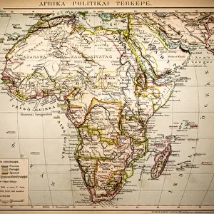
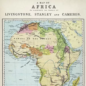
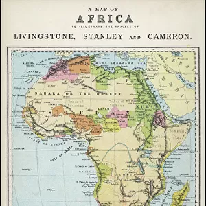
Jigsaw Puzzle : Map Of Central Africa Circa 1930. From The Modern Atlas Of The World Published Circa 1930


![]()
Jigsaw Puzzles from Design Pics
Map Of Central Africa Circa 1930. From The Modern Atlas Of The World Published Circa 1930
Design Pics offers Distinctively Different Imagery representing over 1,500 contributors
Media ID 18193042
© Ken Welsh / Design Pics
Abyssinia Africa Belgian Central Colonies Congo Italian Kenya Madagascar Maps Northern South Southern Tanganyika Transvaal Uganda Wars West World Angola Bechuanaland Equatorial Possessions Protectorate Protectorates Rhodesia Somaliland
Jigsaw Puzzle (1014 Pieces)
Discover the past with our captivating jigsaw puzzles from the Media Storehouse collection. This intriguing puzzle features an historic map of Central Africa, circa 1930, taken from "The Modern Atlas Of The World" published during that era by Ken Welsh. Immerse yourself in the rich history of this region and enjoy the satisfying experience of piecing together this vintage map. Transport yourself back in time while sharpening your problem-solving skills and creating a beautiful display piece. Bring history to life, one piece at a time.
Made in the USA, 1014-piece puzzles measure 20" x 30" (50.8 x 76.2 cm). Every puzzle is meticulously printed on glossy photo paper, which has a strong 1.33 mm thickness. Delivered in a black storage cardboard box, these puzzles are both stylish and practical. (Note: puzzles contain small parts and are not suitable for children under 3 years of age.)
Jigsaw Puzzles are an ideal gift for any occasion
Estimated Product Size is 76cm x 50.8cm (29.9" x 20")
These are individually made so all sizes are approximate
Artwork printed orientated as per the preview above, with landscape (horizontal) orientation to match the source image.
FEATURES IN THESE COLLECTIONS
> Africa
> Angola
> Related Images
> Africa
> Kenya
> Related Images
> Africa
> Madagascar
> Maps
> Africa
> Madagascar
> Related Images
> Africa
> South Africa
> Maps
> Africa
> South Africa
> Related Images
> Africa
> Uganda
> Related Images
EDITORS COMMENTS
This print showcases a Map of Central Africa circa 1930, taken from The Modern Atlas of the World published around the same time. The map provides a fascinating glimpse into the geopolitical landscape of this region during that era. The intricate details on the map highlight various European possessions and colonies in Central Africa, including French territories, Italian colonies, Belgian Equatorial regions, and British protectorates such as Uganda and Kenya. It also features prominent African countries like Angola, Abyssinia (modern-day Ethiopia), Madagascar, Congo, Tanganyika (now part of Tanzania), Rhodesia (present-day Zimbabwe), Bechuanaland (Botswana), and Somaliland. The historical significance of this map lies in its depiction of power struggles between European nations for control over African territories. It reflects an era marked by colonialism and conflicts as these powers sought to expand their influence across the continent. Ken Welsh's expertly captured print allows us to appreciate both the artistic beauty and historical value embedded within this vintage map. Whether you are a history enthusiast or simply intrigued by cartography, this piece serves as a window into Central Africa's past while reminding us how far we have come since then.
MADE IN THE USA
Safe Shipping with 30 Day Money Back Guarantee
FREE PERSONALISATION*
We are proud to offer a range of customisation features including Personalised Captions, Color Filters and Picture Zoom Tools
SECURE PAYMENTS
We happily accept a wide range of payment options so you can pay for the things you need in the way that is most convenient for you
* Options may vary by product and licensing agreement. Zoomed Pictures can be adjusted in the Cart.