Fine Art Print > Europe > Denmark > Heritage Sites > Wadden Sea
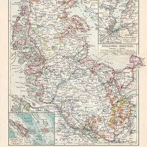
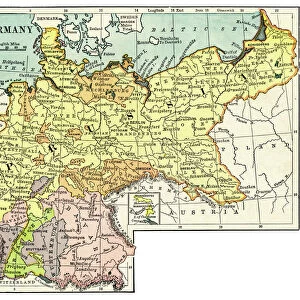
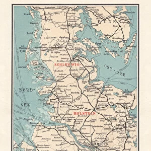
Fine Art Print : Map of Schleswig-Holstein, northernmost state of Germany, lithograph, published 1887


![]()
Fine Art Prints from Fine Art Storehouse
Map of Schleswig-Holstein, northernmost state of Germany, lithograph, published 1887
Map of Schleswig-Holstein, northernmost state of Germany. Lithograph, published in 1887
Unleash your creativity and transform your space into a visual masterpiece!
Media ID 14537608
© This content is subject to copyright
Baltic Sea Bremen Canal Capital Colorful Danish Culture Denmark European Culture Friesland German Culture Hamburg Lubeck Nordfriesland North Frisian Islands North Sea Schleswig Holstein Travel Destination Wadden Sea Fano Flensburg Funen Husum Kiel Kiel Canal Northern Friesland Oldenburg Wattenmeer
20"x16" (+3" Border) Fine Art Print
Discover the rich history and cultural heritage of Schleswig-Holstein with this exquisite, vintage lithograph print from Media Storehouse's Fine Art collection. Published in 1887, this intricately detailed map offers a captivating glimpse into the past, showcasing the northernmost state of Germany with precision and elegance. Add an air of sophistication and historical charm to your home or office decor with this beautiful, collectible piece of art.
20x16 image printed on 26x22 Fine Art Rag Paper with 3" (76mm) white border. Our Fine Art Prints are printed on 300gsm 100% acid free, PH neutral paper with archival properties. This printing method is used by museums and art collections to exhibit photographs and art reproductions.
Our fine art prints are high-quality prints made using a paper called Photo Rag. This 100% cotton rag fibre paper is known for its exceptional image sharpness, rich colors, and high level of detail, making it a popular choice for professional photographers and artists. Photo rag paper is our clear recommendation for a fine art paper print. If you can afford to spend more on a higher quality paper, then Photo Rag is our clear recommendation for a fine art paper print.
Estimated Image Size (if not cropped) is 36cm x 50.8cm (14.2" x 20")
Estimated Product Size is 55.9cm x 66cm (22" x 26")
These are individually made so all sizes are approximate
Artwork printed orientated as per the preview above, with portrait (vertical) orientation to match the source image.
FEATURES IN THESE COLLECTIONS
> Europe
> Denmark
> Heritage Sites
> Wadden Sea
> Europe
> Denmark
> Related Images
> Europe
> Germany
> Heritage Sites
> Wadden Sea
> Europe
> Germany
> Related Images
> Fine Art Storehouse
> Map
> Denmark Maps
> Fine Art Storehouse
> Map
> Historical Maps
EDITORS COMMENTS
This vibrant lithograph from 1887 showcases the captivating Map of Schleswig-Holstein, Germany's northernmost state. The intricate details and colorful engravings depict a region rich in history and natural beauty. From the bustling cities of Hamburg, Flensburg, Bremen, and Lubeck to the serene coastal towns of Husum and Kiel, this map captures the essence of Schleswig-Holstein. The map also highlights significant landmarks such as the North Sea and Baltic Sea, emphasizing the state's close connection with maritime activities. Notably, it features the renowned Schleswig Holstein Wadden Sea National Park—an ecological treasure trove encompassing Nordfriesland and North Frisian Islands—showcasing its importance for conservation efforts. Additionally, this lithograph portrays key engineering marvels like the Kiel Canal (Nord Ostsee Kanal), which connects these two seas through Friesland. It serves as a testament to human ingenuity while blending seamlessly with nature's splendor. Beyond geographical information, this print offers glimpses into Danish culture due to its proximity to Denmark. The mention of Funen Island (Fano) and Romo hints at cross-cultural influences between Germany and Denmark along their shared coastline. With its vertical layout and vivid colors meticulously engraved on paper, this artwork is not only visually stunning but also serves as an invaluable historical document. Whether you are an art enthusiast or a travel aficionado seeking inspiration for your next adventure in Europe
MADE IN THE USA
Safe Shipping with 30 Day Money Back Guarantee
FREE PERSONALISATION*
We are proud to offer a range of customisation features including Personalised Captions, Color Filters and Picture Zoom Tools
SECURE PAYMENTS
We happily accept a wide range of payment options so you can pay for the things you need in the way that is most convenient for you
* Options may vary by product and licensing agreement. Zoomed Pictures can be adjusted in the Cart.