Fine Art Print > Europe > France > Paris > Maps
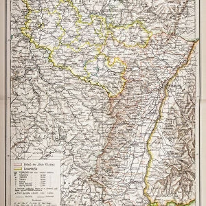
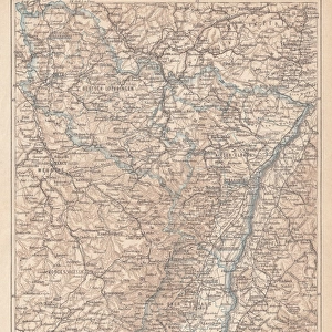
Fine Art Print : France Alsace-Lorraine map 1887


![]()
Fine Art Prints from Fine Art Storehouse
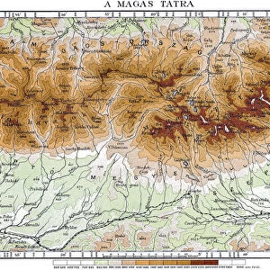
France Alsace-Lorraine map 1887
Map from La Premiere Annee de Geographie par P. Foncin - Paris 1887
Unleash your creativity and transform your space into a visual masterpiece!
THEPALMER
Media ID 20773137
© A 2014 Roberto Adrian Photography
20"x16" (+3" Border) Fine Art Print
Transport yourself back in time with our exquisite Fine Art Print of the Alsace-Lorraine Map from 1887 by THEPALMER. This intricately detailed map, originally published in "La Premiere Annee de Geographie" by P. Foncin in Paris, offers a captivating glimpse into the historical cartography of France. The rich textures and vibrant colors bring the past to life, making this print an essential addition to any home or office decor. Perfect for history enthusiasts, geography buffs, or anyone who appreciates the beauty of historical maps.
20x16 image printed on 26x22 Fine Art Rag Paper with 3" (76mm) white border. Our Fine Art Prints are printed on 300gsm 100% acid free, PH neutral paper with archival properties. This printing method is used by museums and art collections to exhibit photographs and art reproductions.
Our fine art prints are high-quality prints made using a paper called Photo Rag. This 100% cotton rag fibre paper is known for its exceptional image sharpness, rich colors, and high level of detail, making it a popular choice for professional photographers and artists. Photo rag paper is our clear recommendation for a fine art paper print. If you can afford to spend more on a higher quality paper, then Photo Rag is our clear recommendation for a fine art paper print.
Estimated Image Size (if not cropped) is 40.6cm x 49.9cm (16" x 19.6")
Estimated Product Size is 55.9cm x 66cm (22" x 26")
These are individually made so all sizes are approximate
Artwork printed orientated as per the preview above, with portrait (vertical) orientation to match the source image.
FEATURES IN THESE COLLECTIONS
> Europe
> France
> Paris
> Maps
> Maps and Charts
> Related Images
EDITORS COMMENTS
This print showcases a historical gem - the France Alsace-Lorraine map from 1887. Taken from the renowned publication "La Premiere Annee de Geographie" by P. Foncin, this exquisite piece of cartography takes us back to a time when borders were shifting and Europe was undergoing significant changes. The map itself is a testament to the intricate artistry and attention to detail that went into creating such masterpieces in the late 19th century. With its delicate lines, vibrant colors, and meticulously labeled towns and regions, it offers an immersive glimpse into the geographical landscape of France's Alsace-Lorraine region during that era. As we gaze upon this remarkable print by THEPALMER, we are transported to a time when political boundaries were fluid, reflecting the complex history of this region. It serves as a reminder of how geography can be intertwined with cultural identity and national aspirations. Whether you are an avid historian or simply appreciate fine art, this print is sure to captivate your imagination. Its timeless appeal lies not only in its historical significance but also in its ability to evoke curiosity about our past and spark conversations about geopolitical transformations. Displaying this stunning artwork on your wall will undoubtedly become a conversation starter for guests who will marvel at both its aesthetic beauty and rich historical context. So why not bring home a piece of history with this extraordinary France Alsace-Lorraine map from 1887?
MADE IN THE USA
Safe Shipping with 30 Day Money Back Guarantee
FREE PERSONALISATION*
We are proud to offer a range of customisation features including Personalised Captions, Color Filters and Picture Zoom Tools
SECURE PAYMENTS
We happily accept a wide range of payment options so you can pay for the things you need in the way that is most convenient for you
* Options may vary by product and licensing agreement. Zoomed Pictures can be adjusted in the Cart.