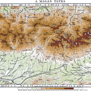
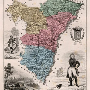
Metal Print > Europe > France > Paris > Maps
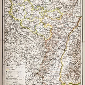
Metal Print : France Alsace-Lorraine map 1887


![]()
Metal Prints from Fine Art Storehouse
France Alsace-Lorraine map 1887
Map from La Premiere Annee de Geographie par P. Foncin - Paris 1887
Unleash your creativity and transform your space into a visual masterpiece!
THEPALMER
Media ID 20773137
© A 2014 Roberto Adrian Photography
16"x20" (51x41cm) Metal Print
Discover the rich history of France with our stunning Metal Print of Alsace-Lorraine Map 1887 from THEPALMER's Fine Art Storehouse collection. This intricately detailed map, originally published in "La Premiere Annee de Geographie" by P. Foncin in Paris 1887, is brought to life through our high-quality Metal Print process. The vibrant colors and sharp lines pop against the sleek, modern metal surface, making it a captivating addition to any home or office. Transport yourself back in time and explore the historical significance of this region with this beautiful and unique piece of decor. Order now and bring a piece of the past into your space.
Made with durable metal and luxurious printing techniques, our metal photo prints go beyond traditional canvases, adding a cool, modern touch to your space. Wall mount on back. Eco-friendly 100% post-consumer recycled ChromaLuxe aluminum surface. The thickness of the print is 0.045". Featuring a Scratch-resistant surface and Rounded corners. Backing hangers are attached to the back of the print and float the print 1/2-inch off the wall when hung, the choice of hanger may vary depending on size and International orders will come with Float Mount hangers only. Finished with a brilliant white high gloss surface for unsurpassed detail and vibrance. Printed using Dye-Sublimation and for best care we recommend a non-ammonia glass cleaner, water, or isopropyl (rubbing) alcohol to prevent harming the print surface. We recommend using a clean, lint-free cloth to wipe off the print. The ultra-hard surface is scratch-resistant, waterproof and weatherproof. Avoid direct sunlight exposure.
Made with durable metal and luxurious printing techniques, metal prints bring images to life and add a modern touch to any space
Estimated Image Size (if not cropped) is 40.6cm x 50.8cm (16" x 20")
Estimated Product Size is 41.2cm x 51.4cm (16.2" x 20.2")
These are individually made so all sizes are approximate
Artwork printed orientated as per the preview above, with portrait (vertical) orientation to match the source image.
FEATURES IN THESE COLLECTIONS
> Europe
> France
> Paris
> Maps
> Maps and Charts
> Related Images
EDITORS COMMENTS
This print showcases a historical gem - the France Alsace-Lorraine map from 1887. Taken from the renowned publication "La Premiere Annee de Geographie" by P. Foncin, this exquisite piece of cartography takes us back to a time when borders were shifting and Europe was undergoing significant changes. The map itself is a testament to the intricate artistry and attention to detail that went into creating such masterpieces in the late 19th century. With its delicate lines, vibrant colors, and meticulously labeled towns and regions, it offers an immersive glimpse into the geographical landscape of France's Alsace-Lorraine region during that era. As we gaze upon this remarkable print by THEPALMER, we are transported to a time when political boundaries were fluid, reflecting the complex history of this region. It serves as a reminder of how geography can be intertwined with cultural identity and national aspirations. Whether you are an avid historian or simply appreciate fine art, this print is sure to captivate your imagination. Its timeless appeal lies not only in its historical significance but also in its ability to evoke curiosity about our past and spark conversations about geopolitical transformations. Displaying this stunning artwork on your wall will undoubtedly become a conversation starter for guests who will marvel at both its aesthetic beauty and rich historical context. So why not bring home a piece of history with this extraordinary France Alsace-Lorraine map from 1887?
MADE IN THE USA
Safe Shipping with 30 Day Money Back Guarantee
FREE PERSONALISATION*
We are proud to offer a range of customisation features including Personalised Captions, Color Filters and Picture Zoom Tools
SECURE PAYMENTS
We happily accept a wide range of payment options so you can pay for the things you need in the way that is most convenient for you
* Options may vary by product and licensing agreement. Zoomed Pictures can be adjusted in the Cart.