Fine Art Print > Animals > Mammals > Cricetidae > Golden Mouse
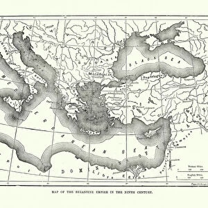
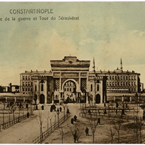
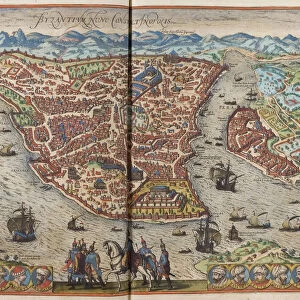
Fine Art Print : Antique map of Constantinople, present day Istanbul


![]()
Fine Art Prints from Fine Art Storehouse
Antique map of Constantinople, present day Istanbul
Unleash your creativity and transform your space into a visual masterpiece!
Hemera Technologies
Media ID 13609419
© Getty Images
Bosphorus Byzantine Constantinople Direction Geography Golden Horn Istanbul Istanbul Legend Location Middle East Place Positioning Turkey Turkey Middle East Bosphorus Strait Byzantium Golden Horn Sea Of Marmara
20"x16" (+3" Border) Fine Art Print
Step back in time with our exquisite Antique Map of Constantinople, now available as a Fine Art Print from Media Storehouse. This stunning piece, published by Hemera Technologies, transports you to the rich history of Istanbul, formerly known as Constantinople. The intricate details of the map showcase the city's historic landmarks, borders, and topography during an era of grand exploration. Bring the timeless beauty of this ancient city into your home or office with our museum-quality Fine Art Prints, expertly printed on premium paper for lasting vibrancy and detail.
20x16 image printed on 26x22 Fine Art Rag Paper with 3" (76mm) white border. Our Fine Art Prints are printed on 300gsm 100% acid free, PH neutral paper with archival properties. This printing method is used by museums and art collections to exhibit photographs and art reproductions.
Our fine art prints are high-quality prints made using a paper called Photo Rag. This 100% cotton rag fibre paper is known for its exceptional image sharpness, rich colors, and high level of detail, making it a popular choice for professional photographers and artists. Photo rag paper is our clear recommendation for a fine art paper print. If you can afford to spend more on a higher quality paper, then Photo Rag is our clear recommendation for a fine art paper print.
Estimated Image Size (if not cropped) is 49.6cm x 40.6cm (19.5" x 16")
Estimated Product Size is 66cm x 55.9cm (26" x 22")
These are individually made so all sizes are approximate
Artwork printed orientated as per the preview above, with landscape (horizontal) orientation to match the source image.
FEATURES IN THESE COLLECTIONS
> Animals
> Mammals
> Cricetidae
> Golden Mouse
> Asia
> Turkey
> Related Images
> Maps and Charts
> Early Maps
> Maps and Charts
> Related Images
> Fine Art Storehouse
> Map
> Historical Maps
EDITORS COMMENTS
This print showcases an antique map of Constantinople, the enchanting city that is now known as Istanbul. With its rich history and cultural significance, this archival piece takes us back in time to explore the ancient wonders of Byzantium. The intricate engravings on this vintage map beautifully depict the geography and positioning of this iconic city, nestled between the Bosphorus Strait and the Sea of Marmara. As we delve into this historical artifact, our eyes are drawn to key landmarks such as the Golden Horn, a natural harbor that has witnessed countless maritime adventures throughout centuries. The detailed legend provides insight into various elements represented on the map, allowing us to navigate through Constantinople's streets and neighborhoods with ease. Transported by Hemera Technologies' skillful photography, we find ourselves immersed in a world where East meets West. This horizontal composition captures every detail in vibrant color, bringing life to each street corner and architectural marvels that have stood tall for generations. With no people present within its frame, this image invites us to reflect upon Constantinople's past glory while contemplating its enduring legacy today. It serves as a reminder of how history shapes our present reality and inspires curiosity about what lies beyond these ancient walls. Whether you're an avid cartography enthusiast or simply captivated by Istanbul's allure, this antique print offers a window into a bygone era - an exquisite addition to any art collection or space longing for timeless beauty.
MADE IN THE USA
Safe Shipping with 30 Day Money Back Guarantee
FREE PERSONALISATION*
We are proud to offer a range of customisation features including Personalised Captions, Color Filters and Picture Zoom Tools
SECURE PAYMENTS
We happily accept a wide range of payment options so you can pay for the things you need in the way that is most convenient for you
* Options may vary by product and licensing agreement. Zoomed Pictures can be adjusted in the Cart.