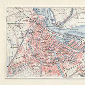
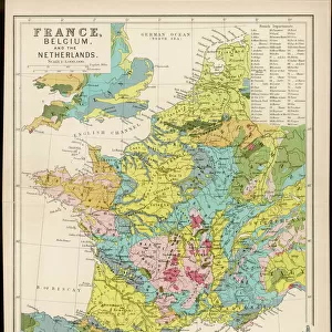
Fine Art Print > Europe > France > Canton > Landes
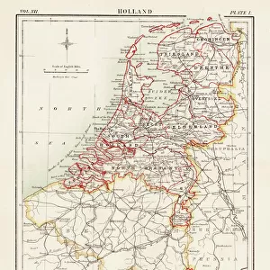
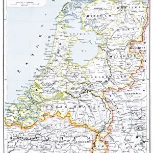
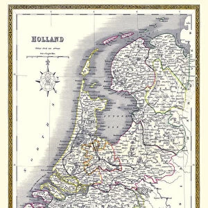
Fine Art Print : Map of the Netherlands, lithograph, published in 1877


![]()
Fine Art Prints from Fine Art Storehouse
Map of the Netherlands, lithograph, published in 1877
Map of the Netherlands. Lithograph, published in 1877
Unleash your creativity and transform your space into a visual masterpiece!
Media ID 13666773
© ZU_09
Amsterdam Antwerp City Belgium Atlantic Ocean Belgium Benelux Contour Drawing Country Geographic Area Dutch Culture Fax Machine Friesland Island Land Netherlands North Sea Rotterdam Storytelling Topographic Map Topography Utrecht Antwerp Belgium Friesland Netherlands
20"x16" (+3" Border) Fine Art Print
Discover the rich history and intricate details of the Netherlands with this stunning 1877 lithograph print from Media Storehouse's Fine Art collection. This exquisite Map of the Netherlands transports you back in time, showcasing the geography and borders of the region as they appeared over a century ago. With its intricate lines and vibrant colors, this fine art print is not only a beautiful addition to your home or office decor, but also a fascinating historical artifact. Bring a piece of the past into your present with Media Storehouse's Fine Art Prints.
20x16 image printed on 26x22 Fine Art Rag Paper with 3" (76mm) white border. Our Fine Art Prints are printed on 300gsm 100% acid free, PH neutral paper with archival properties. This printing method is used by museums and art collections to exhibit photographs and art reproductions.
Our fine art prints are high-quality prints made using a paper called Photo Rag. This 100% cotton rag fibre paper is known for its exceptional image sharpness, rich colors, and high level of detail, making it a popular choice for professional photographers and artists. Photo rag paper is our clear recommendation for a fine art paper print. If you can afford to spend more on a higher quality paper, then Photo Rag is our clear recommendation for a fine art paper print.
Estimated Image Size (if not cropped) is 40.6cm x 50.2cm (16" x 19.8")
Estimated Product Size is 55.9cm x 66cm (22" x 26")
These are individually made so all sizes are approximate
Artwork printed orientated as per the preview above, with portrait (vertical) orientation to match the source image.
FEATURES IN THESE COLLECTIONS
> Arts
> Artists
> O
> Oceanic Oceanic
> Europe
> Belgium
> Related Images
> Europe
> France
> Canton
> Landes
> Europe
> Netherlands
> Amsterdam
> Europe
> Netherlands
> Maps
> Europe
> Netherlands
> Posters
> Europe
> Netherlands
> Related Images
> Fine Art Storehouse
> Map
> Historical Maps
EDITORS COMMENTS
This lithograph, published in 1877, showcases a Map of the Netherlands with intricate details that transport us back to a bygone era. The antique print exudes an air of history and storytelling as it reveals the topography and contours of this enchanting country. From its bustling capital city Amsterdam to the cultural hubs of Utrecht and Rotterdam, every major city is meticulously engraved on this vertical masterpiece. The map extends beyond Dutch borders, encompassing Antwerp in Belgium and other regions within the Benelux area. It also highlights Friesland, an island nestled between the North Sea and Atlantic Ocean. This exquisite piece offers a glimpse into Dutch culture while providing valuable insights into European geography during that time. As we admire this remarkable lithograph, we are reminded of how far technology has advanced since its creation. In contrast to today's digital maps accessible through our smartphones or even fax machines from more recent times, this handcrafted work reflects the artistry involved in cartography centuries ago. With no people present in this contour drawing captured through photography in 2015, it serves as a timeless reminder of our connection to ancient history and land formations that have shaped nations throughout generations. Whether you are a lover of art or simply intrigued by historical relics like this one, let your imagination wander as you explore the rich tapestry woven within this stunning Map of the Netherlands from 1877.
MADE IN THE USA
Safe Shipping with 30 Day Money Back Guarantee
FREE PERSONALISATION*
We are proud to offer a range of customisation features including Personalised Captions, Color Filters and Picture Zoom Tools
SECURE PAYMENTS
We happily accept a wide range of payment options so you can pay for the things you need in the way that is most convenient for you
* Options may vary by product and licensing agreement. Zoomed Pictures can be adjusted in the Cart.