Fine Art Print > North America > United States of America > New York > New York > Maps
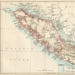
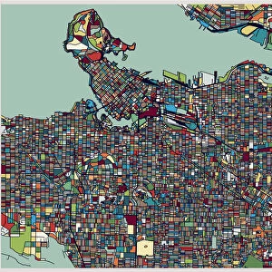
Fine Art Print : Vancouver island map 1885


![]()
Fine Art Prints from Fine Art Storehouse
Vancouver island map 1885
Encyclopedia Britannica 9th Edition New York Charles Scribners and Sons 1885 Vol XXIV
Unleash your creativity and transform your space into a visual masterpiece!
THEPALMER
Media ID 14756610
© This content is subject to copyright
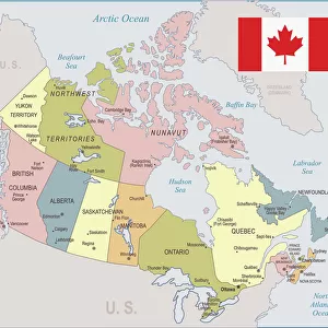
British Columbia Canada Island Vancouver
20"x16" (+3" Border) Fine Art Print
Step back in time with our exquisite Fine Art Print of Vancouver Island from ThePalmer's map in the 9th Edition of Encyclopedia Britannica, published by Charles Scribner's Sons in 1885. This vintage cartographic masterpiece showcases intricate detail and historical accuracy, making it a stunning addition to any home or office. Transport yourself to a bygone era with this beautiful, museum-quality print.
20x16 image printed on 26x22 Fine Art Rag Paper with 3" (76mm) white border. Our Fine Art Prints are printed on 300gsm 100% acid free, PH neutral paper with archival properties. This printing method is used by museums and art collections to exhibit photographs and art reproductions.
Our fine art prints are high-quality prints made using a paper called Photo Rag. This 100% cotton rag fibre paper is known for its exceptional image sharpness, rich colors, and high level of detail, making it a popular choice for professional photographers and artists. Photo rag paper is our clear recommendation for a fine art paper print. If you can afford to spend more on a higher quality paper, then Photo Rag is our clear recommendation for a fine art paper print.
Estimated Image Size (if not cropped) is 50.8cm x 40.6cm (20" x 16")
Estimated Product Size is 66cm x 55.9cm (26" x 22")
These are individually made so all sizes are approximate
Artwork printed orientated as per the preview above, with landscape (horizontal) orientation to match the source image.
FEATURES IN THESE COLLECTIONS
> Maps and Charts
> Related Images
> North America
> Canada
> Maps
> North America
> Canada
> Related Images
> North America
> Canada
> Vancouver
> North America
> United States of America
> New York
> New York
> Maps
> North America
> United States of America
> New York
> Related Images
> Fine Art Storehouse
> Map
> Historical Maps
EDITORS COMMENTS
This print showcases a historical gem, the Vancouver Island map from 1885. A true treasure for history enthusiasts and cartography aficionados alike, this piece takes us back to an era when exploration and discovery were at their peak. The intricate details of this map, carefully preserved in the Encyclopedia Britannica's 9th Edition, transport us to a time when British Columbia was still in its infancy. The artistry of this print is evident as it captures every contour and coastline of Vancouver Island with remarkable precision. From its rugged shores to its majestic mountains, one can almost feel the allure of this Canadian island through the lens of Charles Scribners and Sons' camera. As we gaze upon this vintage masterpiece by THEPALMER, we are reminded not only of the rich history that lies within these borders but also of the countless stories waiting to be unraveled. This photograph serves as a visual portal into an era long gone but never forgotten. Whether you have personal ties to Vancouver or simply appreciate the beauty found in old maps, this print is sure to spark curiosity and ignite conversations about our collective past. Let it grace your walls as a testament to both human ingenuity and nature's grandeur – a timeless tribute capturing the essence of Vancouver Island in all its glory.
MADE IN THE USA
Safe Shipping with 30 Day Money Back Guarantee
FREE PERSONALISATION*
We are proud to offer a range of customisation features including Personalised Captions, Color Filters and Picture Zoom Tools
SECURE PAYMENTS
We happily accept a wide range of payment options so you can pay for the things you need in the way that is most convenient for you
* Options may vary by product and licensing agreement. Zoomed Pictures can be adjusted in the Cart.