Framed Print > North America > United States of America > New York > New York > Maps
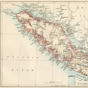
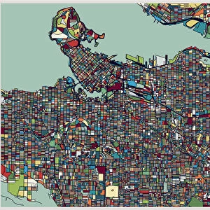
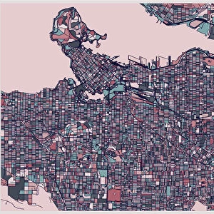
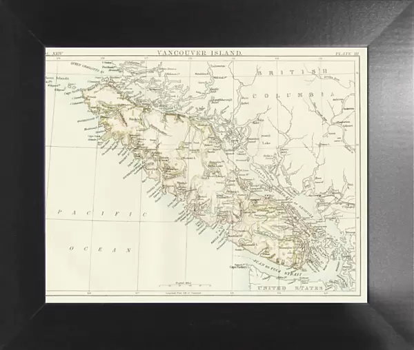
Framed Print : Vancouver island map 1885


![]()
Framed Photos from Fine Art Storehouse
Vancouver island map 1885
Encyclopedia Britannica 9th Edition New York Charles Scribners and Sons 1885 Vol XXIV
Unleash your creativity and transform your space into a visual masterpiece!
THEPALMER
Media ID 14756610
© This content is subject to copyright
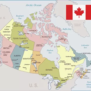
British Columbia Canada Island Vancouver
12"x10" Modern Frame
Introducing the captivating "Vancouver Island Map 1885" from our Media Storehouse Framed Prints collection. This exquisite piece of historical cartography is a reproduction of an original chart taken from the Encyclopedia Britannica 9th Edition, published by Charles Scribner's Sons in New York City in 1885. The map, titled by its creator as "THEPALMER," offers a fascinating glimpse into the geographic knowledge of the time. Delve into the rich history of Vancouver Island with this stunning, vintage-inspired framed print, perfect for adding a touch of antique charm to any room in your home or office.
10x8 Print in an MDF Wooden Frame with 180 gsm Satin Finish Paper. Glazed using shatter proof thin plexi glass. Frame thickness is 1 inch and depth 0.75 inch. Fluted cardboard backing held with clips. Supplied ready to hang with sawtooth hanger and rubber bumpers. Spot clean with a damp cloth. Packaged foam wrapped in a card.
Contemporary Framed and Mounted Prints - Professionally Made and Ready to Hang
Estimated Image Size (if not cropped) is 25.4cm x 25.4cm (10" x 10")
Estimated Product Size is 30.5cm x 25.4cm (12" x 10")
These are individually made so all sizes are approximate
Artwork printed orientated as per the preview above, with landscape (horizontal) or portrait (vertical) orientation to match the source image.
FEATURES IN THESE COLLECTIONS
> Fine Art Storehouse
> Map
> Historical Maps
> Maps and Charts
> Related Images
> North America
> Canada
> Maps
> North America
> Canada
> Related Images
> North America
> Canada
> Vancouver
> North America
> United States of America
> New York
> New York
> Maps
> North America
> United States of America
> New York
> Related Images
EDITORS COMMENTS
This print showcases a historical gem, the Vancouver Island map from 1885. A true treasure for history enthusiasts and cartography aficionados alike, this piece takes us back to an era when exploration and discovery were at their peak. The intricate details of this map, carefully preserved in the Encyclopedia Britannica's 9th Edition, transport us to a time when British Columbia was still in its infancy. The artistry of this print is evident as it captures every contour and coastline of Vancouver Island with remarkable precision. From its rugged shores to its majestic mountains, one can almost feel the allure of this Canadian island through the lens of Charles Scribners and Sons' camera. As we gaze upon this vintage masterpiece by THEPALMER, we are reminded not only of the rich history that lies within these borders but also of the countless stories waiting to be unraveled. This photograph serves as a visual portal into an era long gone but never forgotten. Whether you have personal ties to Vancouver or simply appreciate the beauty found in old maps, this print is sure to spark curiosity and ignite conversations about our collective past. Let it grace your walls as a testament to both human ingenuity and nature's grandeur – a timeless tribute capturing the essence of Vancouver Island in all its glory.
MADE IN THE USA
Safe Shipping with 30 Day Money Back Guarantee
FREE PERSONALISATION*
We are proud to offer a range of customisation features including Personalised Captions, Color Filters and Picture Zoom Tools
SECURE PAYMENTS
We happily accept a wide range of payment options so you can pay for the things you need in the way that is most convenient for you
* Options may vary by product and licensing agreement. Zoomed Pictures can be adjusted in the Cart.