Fine Art Print > North America > Dominican Republic > Maps
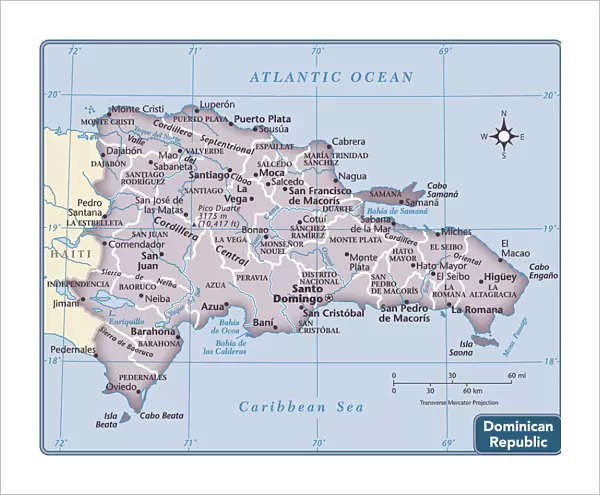
Fine Art Print : Dominican Republic country map


Please select a smaller print size for this image
![]()
Fine Art Prints from Fine Art Storehouse
Dominican Republic country map
2011 edition
Unleash your creativity and transform your space into a visual masterpiece!
Media ID 14432303
14"x11" (+3" Border) Fine Art Print
Discover the captivating beauty of the Dominican Republic with our exquisite Fine Art Print from Media Storehouse. This 2011 edition map of the Dominican Republic is not just a geographical representation, but a work of art in itself. Each detail is meticulously rendered, from the winding rivers to the lush green forests and the pristine beaches. Bring a piece of Caribbean paradise into your home or office with this stunning fine art print. Perfect for travel enthusiasts, history buffs, or anyone who appreciates the artistry of cartography. Order yours today and let the magic of the Dominican Republic transport you.
20x16 image printed on 26x22 Fine Art Rag Paper with 3" (76mm) white border. Our Fine Art Prints are printed on 300gsm 100% acid free, PH neutral paper with archival properties. This printing method is used by museums and art collections to exhibit photographs and art reproductions.
Our fine art prints are high-quality prints made using a paper called Photo Rag. This 100% cotton rag fibre paper is known for its exceptional image sharpness, rich colors, and high level of detail, making it a popular choice for professional photographers and artists. Photo rag paper is our clear recommendation for a fine art paper print. If you can afford to spend more on a higher quality paper, then Photo Rag is our clear recommendation for a fine art paper print.
Estimated Image Size (if not cropped) is 50.8cm x 40.6cm (20" x 16")
Estimated Product Size is 50.8cm x 43.2cm (20" x 17")
These are individually made so all sizes are approximate
Artwork printed orientated as per the preview above, with landscape (horizontal) orientation to match the source image.
FEATURES IN THESE COLLECTIONS
> Maps and Charts
> Related Images
> North America
> Dominican Republic
> Maps
> North America
> Dominican Republic
> Related Images
> Fine Art Storehouse
> Map
> Reference Maps
EDITORS COMMENTS
This print showcases the Dominican Republic country map, specifically the 2011 edition. With intricate details and vibrant colors, this artwork from Fine Art Storehouse is a true masterpiece that captures the essence of this Caribbean nation. The map depicts the diverse geography of the Dominican Republic, including its stunning coastlines, lush rainforests, majestic mountains, and bustling cities. Each region is clearly marked with labels that allow viewers to explore and appreciate the country's rich topography. Beyond being a mere representation of landforms and boundaries, this print also serves as a window into the cultural heritage of the Dominican Republic. The map highlights important landmarks such as historical sites, national parks, iconic beaches, and charming towns. It invites us to embark on an imaginary journey through this enchanting destination. Whether you are planning a trip or simply have an affinity for cartography and travel photography, this artwork will undoubtedly captivate your attention. Its high-quality printing ensures every detail is crisp and clear while adding a touch of elegance to any space it adorns. Perfect for home decor or office spaces alike, this print offers both aesthetic appeal and educational value. It sparks curiosity about one of Central America's most beautiful countries while serving as a reminder of our interconnected world. Let yourself be transported by gazing at this remarkable piece that celebrates both artistry and geography in perfect harmony.
MADE IN THE USA
Safe Shipping with 30 Day Money Back Guarantee
FREE PERSONALISATION*
We are proud to offer a range of customisation features including Personalised Captions, Color Filters and Picture Zoom Tools
SECURE PAYMENTS
We happily accept a wide range of payment options so you can pay for the things you need in the way that is most convenient for you
* Options may vary by product and licensing agreement. Zoomed Pictures can be adjusted in the Cart.