Photographic Print > North America > Dominican Republic > Maps
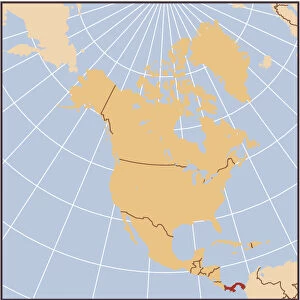
Photographic Print : Dominican Republic country map


![]()
Photo Prints from Fine Art Storehouse
Dominican Republic country map
2011 edition
Unleash your creativity and transform your space into a visual masterpiece!
Media ID 14432303
10"x8" Photo Print
Experience the vibrant culture and beauty of the Dominican Republic with our exquisite Fine Art Storehouse Photographic Prints. This stunning image of the Dominican Republic country map (2011 edition) is meticulously captured and expertly printed to bring the rich details and colors to life. Each print is produced using high-quality materials and techniques, ensuring a stunning piece of art that will add character and depth to any space. Whether you're an avid traveler or simply appreciate the artistry of cartography, this Fine Art Storehouse Photographic Print of the Dominican Republic country map is a must-have addition to your collection. Bring a piece of the Caribbean into your home or office today.
Photo prints are produced on Kodak professional photo paper resulting in timeless and breath-taking prints which are also ideal for framing. The colors produced are rich and vivid, with accurate blacks and pristine whites, resulting in prints that are truly timeless and magnificent. Whether you're looking to display your prints in your home, office, or gallery, our range of photographic prints are sure to impress. Dimensions refers to the size of the paper in inches.
Our Photo Prints are in a large range of sizes and are printed on Archival Quality Paper for excellent colour reproduction and longevity. They are ideal for framing (our Framed Prints use these) at a reasonable cost. Alternatives include cheaper Poster Prints and higher quality Fine Art Paper, the choice of which is largely dependant on your budget.
Estimated Product Size is 25.4cm x 20.3cm (10" x 8")
These are individually made so all sizes are approximate
Artwork printed orientated as per the preview above, with landscape (horizontal) or portrait (vertical) orientation to match the source image.
FEATURES IN THESE COLLECTIONS
> Fine Art Storehouse
> Map
> Reference Maps
> Maps and Charts
> Related Images
> North America
> Dominican Republic
> Maps
> North America
> Dominican Republic
> Related Images
EDITORS COMMENTS
This print showcases the Dominican Republic country map, specifically the 2011 edition. With intricate details and vibrant colors, this artwork from Fine Art Storehouse is a true masterpiece that captures the essence of this Caribbean nation. The map depicts the diverse geography of the Dominican Republic, including its stunning coastlines, lush rainforests, majestic mountains, and bustling cities. Each region is clearly marked with labels that allow viewers to explore and appreciate the country's rich topography. Beyond being a mere representation of landforms and boundaries, this print also serves as a window into the cultural heritage of the Dominican Republic. The map highlights important landmarks such as historical sites, national parks, iconic beaches, and charming towns. It invites us to embark on an imaginary journey through this enchanting destination. Whether you are planning a trip or simply have an affinity for cartography and travel photography, this artwork will undoubtedly captivate your attention. Its high-quality printing ensures every detail is crisp and clear while adding a touch of elegance to any space it adorns. Perfect for home decor or office spaces alike, this print offers both aesthetic appeal and educational value. It sparks curiosity about one of Central America's most beautiful countries while serving as a reminder of our interconnected world. Let yourself be transported by gazing at this remarkable piece that celebrates both artistry and geography in perfect harmony.
MADE IN THE USA
Safe Shipping with 30 Day Money Back Guarantee
FREE PERSONALISATION*
We are proud to offer a range of customisation features including Personalised Captions, Color Filters and Picture Zoom Tools
SECURE PAYMENTS
We happily accept a wide range of payment options so you can pay for the things you need in the way that is most convenient for you
* Options may vary by product and licensing agreement. Zoomed Pictures can be adjusted in the Cart.