Fine Art Print > Aerial Photography > Related Images
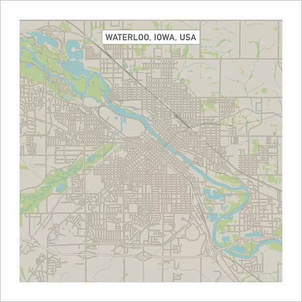
Fine Art Print : Waterloo Iowa US City Street Map

![]()
Fine Art Prints from Fine Art Storehouse
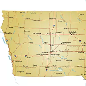
Waterloo Iowa US City Street Map
Vector Illustration of a City Street Map of Waterloo, Iowa, USA. Scale 1:60, 000.
All source data is in the public domain.
U.S. Geological Survey, US Topo
Used Layers:
USGS The National Map: National Hydrography Dataset (NHD)
USGS The National Map: National Transportation Dataset (NTD)
Unleash your creativity and transform your space into a visual masterpiece!
Frank Ramspott
Media ID 15192914
© Frank Ramspott, all rights reserved
Aerial View City Map Computer Graphic Directly Above Downtown District Gray Iowa Road Map Text Waterloo Digitally Generated Image Green Color White Color
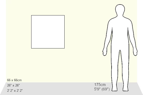
20"x20" (+3" Border) Fine Art Print
Discover the charm of Waterloo, Iowa with our exquisite Fine Art Print of the city street map by Frank Ramspott from Fine Art Storehouse. This stunning vector illustration offers a unique perspective of the US city, meticulously crafted from public domain data at a scale of 1:60,000. Bring the history and character of Waterloo into your home or office with this beautiful and intricately detailed piece of art. Order now and let the allure of this quintessential American city be a part of your daily life.
20x20 image printed on 26x26 Fine Art Rag Paper with 3" (76mm) white border. Our Fine Art Prints are printed on 300gsm 100% acid free, PH neutral paper with archival properties. This printing method is used by museums and art collections to exhibit photographs and art reproductions.
Our fine art prints are high-quality prints made using a paper called Photo Rag. This 100% cotton rag fibre paper is known for its exceptional image sharpness, rich colors, and high level of detail, making it a popular choice for professional photographers and artists. Photo rag paper is our clear recommendation for a fine art paper print. If you can afford to spend more on a higher quality paper, then Photo Rag is our clear recommendation for a fine art paper print.
Estimated Image Size (if not cropped) is 50.8cm x 50.8cm (20" x 20")
Estimated Product Size is 66cm x 66cm (26" x 26")
These are individually made so all sizes are approximate
Artwork printed orientated as per the preview above, with landscape (horizontal) or portrait (vertical) orientation to match the source image.
FEATURES IN THESE COLLECTIONS
> Aerial Photography
> Related Images
> Animals
> Insects
> Hemiptera
> Green Scale
> Arts
> Contemporary art
> Digital artwork
> Street art
> Arts
> Landscape paintings
> Waterfall and river artworks
> River artworks
> Arts
> Portraits
> Pop art gallery
> Street art portraits
> Arts
> Street art graffiti
> Digital art
> Digital paintings
> Arts
> Street art graffiti
> Digital art
> Vector illustrations
> Maps and Charts
> Geological Map
> Maps and Charts
> Related Images
> North America
> United States of America
> Iowa
> Iowa City
> Fine Art Storehouse
> Map
> Street Maps
> Fine Art Storehouse
> Map
> USA Maps
EDITORS COMMENTS
This print showcases a meticulously detailed vector illustration of the vibrant city street map of Waterloo, Iowa, USA. With a scale of 1:60,000, every intricate aspect is beautifully captured in this artwork. The source data used for creating this masterpiece is in the public domain and comes from reliable sources such as the U. S. Geological Survey and US Topo. The various layers utilized include the USGS National Hydrography Dataset (NHD) and National Transportation Dataset (NTD), ensuring accuracy and precision in depicting water bodies like lakes and rivers, streets, roads, and other essential elements that make up this dynamic urban landscape. With its digitally generated image design, this visually striking composition presents an aerial view directly above Waterloo's downtown district. The color palette consists of shades of gray with pops of blue representing water bodies, white symbolizing roadways and buildings' outlines while green signifies lush areas. This piece by Frank Ramspott brings together cartography expertise with computer graphics to create a stunning representation of Waterloo's physical geography. This print offers a unique perspective on the cityscape without any human presence but still manages to capture its essence flawlessly. Perfect for enthusiasts interested in maps or those seeking to adorn their spaces with visually appealing art pieces showcasing their love for cities or hometowns - this artwork will undoubtedly be an eye-catching addition to any collection.
MADE IN THE USA
Safe Shipping with 30 Day Money Back Guarantee
FREE PERSONALISATION*
We are proud to offer a range of customisation features including Personalised Captions, Color Filters and Picture Zoom Tools
SECURE PAYMENTS
We happily accept a wide range of payment options so you can pay for the things you need in the way that is most convenient for you
* Options may vary by product and licensing agreement. Zoomed Pictures can be adjusted in the Cart.