Photographic Print > Aerial Photography > Related Images
Photographic Print : Waterloo Iowa US City Street Map


![]()
Photo Prints from Fine Art Storehouse
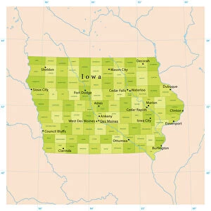
Waterloo Iowa US City Street Map
Vector Illustration of a City Street Map of Waterloo, Iowa, USA. Scale 1:60, 000.
All source data is in the public domain.
U.S. Geological Survey, US Topo
Used Layers:
USGS The National Map: National Hydrography Dataset (NHD)
USGS The National Map: National Transportation Dataset (NTD)
Unleash your creativity and transform your space into a visual masterpiece!
Frank Ramspott
Media ID 15192914
© Frank Ramspott, all rights reserved
Aerial View City Map Computer Graphic Directly Above Downtown District Gray Iowa Road Map Text Waterloo Digitally Generated Image Green Color White Color
10"x10" Photo Print
Discover the charm of Waterloo, Iowa, USA, with our exquisite photographic print from Media Storehouse's Fine Art Storehouse. This stunning piece, created by Frank Ramspott, is a vector illustration of a city street map of Waterloo, meticulously crafted with a scale of 1:60,000. With all source data in the public domain and hailing from the United States, this print is not only a beautiful addition to your home or office décor but also an educational and intriguing conversation starter. Immerse yourself in the history and character of Waterloo with this unique and captivating work of art.
Photo prints are produced on Kodak professional photo paper resulting in timeless and breath-taking prints which are also ideal for framing. The colors produced are rich and vivid, with accurate blacks and pristine whites, resulting in prints that are truly timeless and magnificent. Whether you're looking to display your prints in your home, office, or gallery, our range of photographic prints are sure to impress. Dimensions refers to the size of the paper in inches.
Our Photo Prints are in a large range of sizes and are printed on Archival Quality Paper for excellent colour reproduction and longevity. They are ideal for framing (our Framed Prints use these) at a reasonable cost. Alternatives include cheaper Poster Prints and higher quality Fine Art Paper, the choice of which is largely dependant on your budget.
Estimated Product Size is 25.4cm x 25.4cm (10" x 10")
These are individually made so all sizes are approximate
Artwork printed orientated as per the preview above, with landscape (horizontal) or portrait (vertical) orientation to match the source image.
FEATURES IN THESE COLLECTIONS
> Fine Art Storehouse
> Map
> Street Maps
> Fine Art Storehouse
> Map
> USA Maps
> Aerial Photography
> Related Images
> Animals
> Insects
> Hemiptera
> Green Scale
> Arts
> Contemporary art
> Digital artwork
> Street art
> Arts
> Landscape paintings
> Waterfall and river artworks
> River artworks
> Arts
> Portraits
> Pop art gallery
> Street art portraits
> Arts
> Street art graffiti
> Digital art
> Digital paintings
> Arts
> Street art graffiti
> Digital art
> Vector illustrations
> Maps and Charts
> Geological Map
> Maps and Charts
> Related Images
> North America
> United States of America
> Iowa
> Iowa City
EDITORS COMMENTS
This print showcases a meticulously detailed vector illustration of the vibrant city street map of Waterloo, Iowa, USA. With a scale of 1:60,000, every intricate aspect is beautifully captured in this artwork. The source data used for creating this masterpiece is in the public domain and comes from reliable sources such as the U. S. Geological Survey and US Topo. The various layers utilized include the USGS National Hydrography Dataset (NHD) and National Transportation Dataset (NTD), ensuring accuracy and precision in depicting water bodies like lakes and rivers, streets, roads, and other essential elements that make up this dynamic urban landscape. With its digitally generated image design, this visually striking composition presents an aerial view directly above Waterloo's downtown district. The color palette consists of shades of gray with pops of blue representing water bodies, white symbolizing roadways and buildings' outlines while green signifies lush areas. This piece by Frank Ramspott brings together cartography expertise with computer graphics to create a stunning representation of Waterloo's physical geography. This print offers a unique perspective on the cityscape without any human presence but still manages to capture its essence flawlessly. Perfect for enthusiasts interested in maps or those seeking to adorn their spaces with visually appealing art pieces showcasing their love for cities or hometowns - this artwork will undoubtedly be an eye-catching addition to any collection.
MADE IN THE USA
Safe Shipping with 30 Day Money Back Guarantee
FREE PERSONALISATION*
We are proud to offer a range of customisation features including Personalised Captions, Color Filters and Picture Zoom Tools
SECURE PAYMENTS
We happily accept a wide range of payment options so you can pay for the things you need in the way that is most convenient for you
* Options may vary by product and licensing agreement. Zoomed Pictures can be adjusted in the Cart.