Fine Art Print > North America > United States of America > Maps
Fine Art Print : United States South West Central map 1897


![]()
Fine Art Prints from Fine Art Storehouse
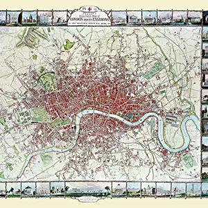
United States South West Central map 1897
The World-Wide Atlas of Modern Geography, Political and Physical W. & A.K. Johnston - London 1897
Unleash your creativity and transform your space into a visual masterpiece!
THEPALMER
Media ID 14457453
© Roberto A Sanchez
Atlas Country Geographic Area Earth Midsection New Mexico Paper Texas West Direction World Map Retro Styled
20"x16" (+3" Border) Fine Art Print
Discover the rich history of cartography with this stunning fine art print from Media Storehouse. Featuring an 1897 United States South West Central map by THEPALMER from The World-Wide Atlas of Modern Geography, Political and Physical W. & A.K. Johnston, London. This intricately detailed map transports you back in time, offering a captivating glimpse into the geographical knowledge of the late 19th century. Bring history into your home or office with this beautiful and authentic piece of cartographic art.
20x16 image printed on 26x22 Fine Art Rag Paper with 3" (76mm) white border. Our Fine Art Prints are printed on 300gsm 100% acid free, PH neutral paper with archival properties. This printing method is used by museums and art collections to exhibit photographs and art reproductions.
Our fine art prints are high-quality prints made using a paper called Photo Rag. This 100% cotton rag fibre paper is known for its exceptional image sharpness, rich colors, and high level of detail, making it a popular choice for professional photographers and artists. Photo rag paper is our clear recommendation for a fine art paper print. If you can afford to spend more on a higher quality paper, then Photo Rag is our clear recommendation for a fine art paper print.
Estimated Image Size (if not cropped) is 50.8cm x 40.6cm (20" x 16")
Estimated Product Size is 66cm x 55.9cm (26" x 22")
These are individually made so all sizes are approximate
Artwork printed orientated as per the preview above, with landscape (horizontal) orientation to match the source image.
FEATURES IN THESE COLLECTIONS
> Europe
> United Kingdom
> England
> London
> Politics
> Related Images
> Maps and Charts
> Related Images
> Maps and Charts
> World
> North America
> Mexico
> Related Images
> North America
> United States of America
> Maps
> North America
> United States of America
> New Mexico
> Related Images
> North America
> United States of America
> Texas
> Related Images
> Fine Art Storehouse
> Map
> Historical Maps
> Fine Art Storehouse
> Map
> USA Maps
EDITORS COMMENTS
This print takes us back in time to the year 1897, when cartography was a meticulous art form. The image showcases a United States South West Central map from "The World-Wide Atlas of Modern Geography, Political and Physical" by W. & A. K. Johnston, published in London during that era. With its retro-styled charm and antique appeal, this engraved image transports us to an age where paper maps were treasured possessions. The intricate details of the engraving highlight the physical geography of the midsection of North America, specifically focusing on Texas and New Mexico. As we gaze upon this vintage masterpiece, we are reminded of how far our understanding of our world has come since then. This old-world representation captures not only the vastness and beauty of Earth's landmasses but also serves as a testament to human curiosity and exploration. "The United States South West Central map 1897" is more than just an artistic relic; it symbolizes our collective desire to comprehend and navigate through our country's geographic area. It invites us to reflect on history while appreciating the advancements made in modern cartography. Brought to you by THEPALMER at Fine Art Storehouse, this exceptional print preserves a piece of cartographic heritage for all enthusiasts who appreciate both artistry and historical significance within their home or office spaces.
MADE IN THE USA
Safe Shipping with 30 Day Money Back Guarantee
FREE PERSONALISATION*
We are proud to offer a range of customisation features including Personalised Captions, Color Filters and Picture Zoom Tools
SECURE PAYMENTS
We happily accept a wide range of payment options so you can pay for the things you need in the way that is most convenient for you
* Options may vary by product and licensing agreement. Zoomed Pictures can be adjusted in the Cart.