Framed Print > North America > United States of America > Maps
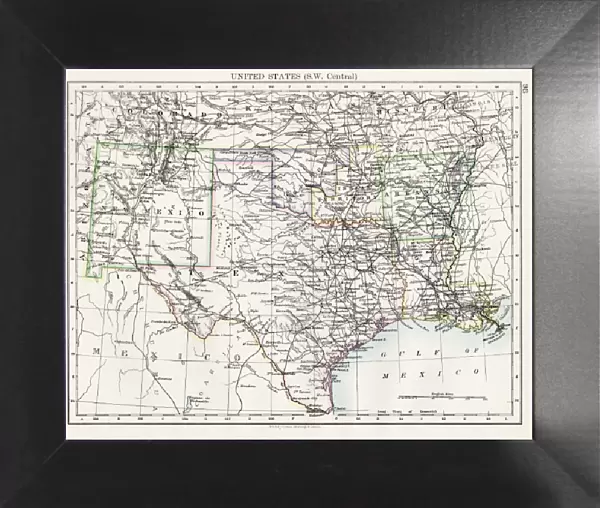
Framed Print : United States South West Central map 1897


![]()
Framed Photos from Fine Art Storehouse
United States South West Central map 1897
The World-Wide Atlas of Modern Geography, Political and Physical W. & A.K. Johnston - London 1897
Unleash your creativity and transform your space into a visual masterpiece!
THEPALMER
Media ID 14457453
© Roberto A Sanchez
Atlas Country Geographic Area Earth Midsection New Mexico North America Paper Texas West Direction World Map Retro Styled
12"x10" Modern Frame
Step back in time with our exquisite framed print featuring the United States South West Central map from 1897 by THEPALMER, originally published in The World-Wide Atlas of Modern Geography. This intricately detailed antique map transports you to a bygone era, beautifully preserved in a high-quality frame. Add a touch of history and character to your space with this unique and captivating piece.
10x8 Print in an MDF Wooden Frame with 180 gsm Satin Finish Paper. Glazed using shatter proof thin plexi glass. Frame thickness is 1 inch and depth 0.75 inch. Fluted cardboard backing held with clips. Supplied ready to hang with sawtooth hanger and rubber bumpers. Spot clean with a damp cloth. Packaged foam wrapped in a card.
Contemporary Framed and Mounted Prints - Professionally Made and Ready to Hang
Estimated Image Size (if not cropped) is 25.4cm x 25.4cm (10" x 10")
Estimated Product Size is 30.5cm x 25.4cm (12" x 10")
These are individually made so all sizes are approximate
Artwork printed orientated as per the preview above, with landscape (horizontal) or portrait (vertical) orientation to match the source image.
FEATURES IN THESE COLLECTIONS
> Fine Art Storehouse
> Map
> Historical Maps
> Fine Art Storehouse
> Map
> USA Maps
> Europe
> United Kingdom
> England
> London
> Politics
> Related Images
> Maps and Charts
> Related Images
> Maps and Charts
> World
> North America
> Mexico
> Related Images
> North America
> Related Images
> North America
> United States of America
> Maps
> North America
> United States of America
> New Mexico
> Related Images
> North America
> United States of America
> Texas
> Related Images
EDITORS COMMENTS
This print takes us back in time to the year 1897, when cartography was a meticulous art form. The image showcases a United States South West Central map from "The World-Wide Atlas of Modern Geography, Political and Physical" by W. & A. K. Johnston, published in London during that era. With its retro-styled charm and antique appeal, this engraved image transports us to an age where paper maps were treasured possessions. The intricate details of the engraving highlight the physical geography of the midsection of North America, specifically focusing on Texas and New Mexico. As we gaze upon this vintage masterpiece, we are reminded of how far our understanding of our world has come since then. This old-world representation captures not only the vastness and beauty of Earth's landmasses but also serves as a testament to human curiosity and exploration. "The United States South West Central map 1897" is more than just an artistic relic; it symbolizes our collective desire to comprehend and navigate through our country's geographic area. It invites us to reflect on history while appreciating the advancements made in modern cartography. Brought to you by THEPALMER at Fine Art Storehouse, this exceptional print preserves a piece of cartographic heritage for all enthusiasts who appreciate both artistry and historical significance within their home or office spaces.
MADE IN THE USA
Safe Shipping with 30 Day Money Back Guarantee
FREE PERSONALISATION*
We are proud to offer a range of customisation features including Personalised Captions, Color Filters and Picture Zoom Tools
SECURE PAYMENTS
We happily accept a wide range of payment options so you can pay for the things you need in the way that is most convenient for you
* Options may vary by product and licensing agreement. Zoomed Pictures can be adjusted in the Cart.