Fine Art Print > Arts > Landscape paintings > Waterfall and river artworks > River artworks
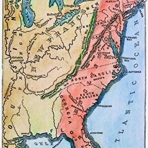
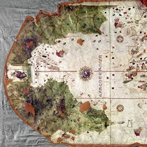
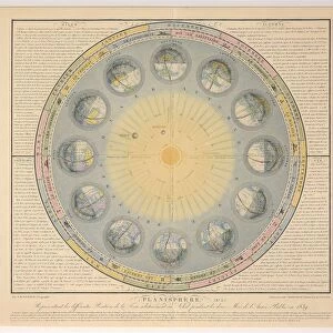
Fine Art Print : MAP OF COLONIAL AMERICA. Delisles map of colonial America, 1718, showing the Mississippi


![]()
Fine Art Prints from Granger
MAP OF COLONIAL AMERICA. Delisles map of colonial America, 1718, showing the Mississippi
MAP OF COLONIAL AMERICA.
Delisles map of colonial America, 1718, showing the Mississippi valley in strikingly accurate detail and the first map to use Texas as a place-name
Granger holds millions of images spanning more than 25,000 years of world history, from before the Stone Age to the dawn of the Space Age
Media ID 12320971
1718 Colony Guillaume Gulf Of Mexico Louisiana Mississippi River United States Valley Delisle Southeast
20"x16" (+3" Border) Fine Art Print
Step back in time with our exquisite Delisle Map of Colonial America, 1718, from the Media Storehouse Fine Art Prints collection. This captivating piece, sourced from Granger Art on Demand, offers a unique glimpse into the past with its intricate depiction of Colonial America. Strikingly accurate for its time, this map showcases the Mississippi Valley in meticulous detail, marking it as the first map to use the name "Texas." Elevate your home or office decor with this historical masterpiece and transport yourself to a time of exploration and discovery.
20x16 image printed on 26x22 Fine Art Rag Paper with 3" (76mm) white border. Our Fine Art Prints are printed on 300gsm 100% acid free, PH neutral paper with archival properties. This printing method is used by museums and art collections to exhibit photographs and art reproductions.
Our fine art prints are high-quality prints made using a paper called Photo Rag. This 100% cotton rag fibre paper is known for its exceptional image sharpness, rich colors, and high level of detail, making it a popular choice for professional photographers and artists. Photo rag paper is our clear recommendation for a fine art paper print. If you can afford to spend more on a higher quality paper, then Photo Rag is our clear recommendation for a fine art paper print.
Estimated Image Size (if not cropped) is 50.8cm x 40.6cm (20" x 16")
Estimated Product Size is 66cm x 55.9cm (26" x 22")
These are individually made so all sizes are approximate
Artwork printed orientated as per the preview above, with landscape (horizontal) orientation to match the source image.
FEATURES IN THESE COLLECTIONS
> Arts
> Landscape paintings
> Waterfall and river artworks
> River artworks
> Historic
> Colonial America illustrations
> Colonial America
> Maps and Charts
> Early Maps
> Maps and Charts
> Related Images
> North America
> Mexico
> Maps
> North America
> Mexico
> Related Images
> Granger Art on Demand
> Maps
EDITORS COMMENTS
This print showcases Delisles map of colonial America from 1718, providing a fascinating glimpse into the early days of American history. The intricate details and accuracy with which the Mississippi valley is depicted are truly striking, making this map an invaluable resource for understanding the geographical landscape of that time. What sets this particular map apart is its distinction as the first to use Texas as a place-name. This groundbreaking inclusion highlights the evolving nature of cartography during this period and sheds light on how territories were being defined and named in colonial America. The image transports us back to a time when French influence was prominent in North America, as evidenced by Guillaume Delisle's involvement in creating this masterpiece. As we study the map, we can envision explorers traversing through Louisiana and navigating along the mighty Mississippi River. The Gulf of Mexico looms large on this map, reminding us of its significance as a gateway for trade and exploration during those early years. It serves as a reminder that even before becoming independent states, these colonies were already interconnected with each other and with foreign powers. Overall, this print offers not only historical value but also aesthetic appeal. It invites us to delve into our past and marvel at how far we have come since then.
MADE IN THE USA
Safe Shipping with 30 Day Money Back Guarantee
FREE PERSONALISATION*
We are proud to offer a range of customisation features including Personalised Captions, Color Filters and Picture Zoom Tools
SECURE PAYMENTS
We happily accept a wide range of payment options so you can pay for the things you need in the way that is most convenient for you
* Options may vary by product and licensing agreement. Zoomed Pictures can be adjusted in the Cart.