Metal Print > Arts > Landscape paintings > Waterfall and river artworks > River artworks
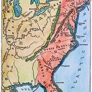
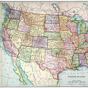
Metal Print : MAP OF COLONIAL AMERICA. Delisles map of colonial America, 1718, showing the Mississippi


![]()
Metal Prints from Granger
MAP OF COLONIAL AMERICA. Delisles map of colonial America, 1718, showing the Mississippi
MAP OF COLONIAL AMERICA.
Delisles map of colonial America, 1718, showing the Mississippi valley in strikingly accurate detail and the first map to use Texas as a place-name
Granger holds millions of images spanning more than 25,000 years of world history, from before the Stone Age to the dawn of the Space Age
Media ID 12320971
1718 Colony Guillaume Gulf Of Mexico Louisiana Mississippi River United States Valley Delisle Southeast
16"x20" (51x41cm) Metal Print
Discover the rich history of Colonial America with our stunning Metal Print of Delisle's Map of Colonial America, 1718. This exquisite piece, featuring the Granger Art on Demand image (140_1636981), showcases the Mississippi Valley in remarkable detail and marks the first use of the name "Texas. Bring history to life in your home or office with this high-quality Metal Print, which preserves the intricate lines and vibrant colors of the original map. Each Metal Print is meticulously crafted using premium metal sheets, ensuring a long-lasting and eye-catching display. Transport yourself back in time and add a touch of history to your space with our Colonial America Metal Print.
Made with durable metal and luxurious printing techniques, our metal photo prints go beyond traditional canvases, adding a cool, modern touch to your space. Wall mount on back. Eco-friendly 100% post-consumer recycled ChromaLuxe aluminum surface. The thickness of the print is 0.045". Featuring a Scratch-resistant surface and Rounded corners. Backing hangers are attached to the back of the print and float the print 1/2-inch off the wall when hung, the choice of hanger may vary depending on size and International orders will come with Float Mount hangers only. Finished with a brilliant white high gloss surface for unsurpassed detail and vibrance. Printed using Dye-Sublimation and for best care we recommend a non-ammonia glass cleaner, water, or isopropyl (rubbing) alcohol to prevent harming the print surface. We recommend using a clean, lint-free cloth to wipe off the print. The ultra-hard surface is scratch-resistant, waterproof and weatherproof. Avoid direct sunlight exposure.
Made with durable metal and luxurious printing techniques, metal prints bring images to life and add a modern touch to any space
Estimated Image Size (if not cropped) is 50.8cm x 40.6cm (20" x 16")
Estimated Product Size is 51.4cm x 41.2cm (20.2" x 16.2")
These are individually made so all sizes are approximate
Artwork printed orientated as per the preview above, with landscape (horizontal) orientation to match the source image.
FEATURES IN THESE COLLECTIONS
> Granger Art on Demand
> Maps
> Arts
> Landscape paintings
> Waterfall and river artworks
> River artworks
> Historic
> Colonial America illustrations
> Colonial America
> Maps and Charts
> Early Maps
> Maps and Charts
> Related Images
> North America
> Mexico
> Maps
> North America
> Mexico
> Related Images
EDITORS COMMENTS
This print showcases Delisles map of colonial America from 1718, providing a fascinating glimpse into the early days of American history. The intricate details and accuracy with which the Mississippi valley is depicted are truly striking, making this map an invaluable resource for understanding the geographical landscape of that time. What sets this particular map apart is its distinction as the first to use Texas as a place-name. This groundbreaking inclusion highlights the evolving nature of cartography during this period and sheds light on how territories were being defined and named in colonial America. The image transports us back to a time when French influence was prominent in North America, as evidenced by Guillaume Delisle's involvement in creating this masterpiece. As we study the map, we can envision explorers traversing through Louisiana and navigating along the mighty Mississippi River. The Gulf of Mexico looms large on this map, reminding us of its significance as a gateway for trade and exploration during those early years. It serves as a reminder that even before becoming independent states, these colonies were already interconnected with each other and with foreign powers. Overall, this print offers not only historical value but also aesthetic appeal. It invites us to delve into our past and marvel at how far we have come since then.
MADE IN THE USA
Safe Shipping with 30 Day Money Back Guarantee
FREE PERSONALISATION*
We are proud to offer a range of customisation features including Personalised Captions, Color Filters and Picture Zoom Tools
SECURE PAYMENTS
We happily accept a wide range of payment options so you can pay for the things you need in the way that is most convenient for you
* Options may vary by product and licensing agreement. Zoomed Pictures can be adjusted in the Cart.