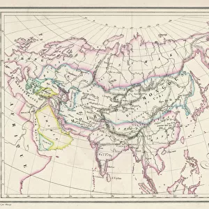
Fine Art Print > Asia > Iran > Lakes > Caspian Sea
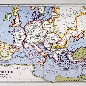
Fine Art Print : Byzantine and Crusaders v. Seljuks, circa 1130 A. D. c1915. Creator: Emery Walker Ltd


![]()
Fine Art Prints from Heritage Images
Byzantine and Crusaders v. Seljuks, circa 1130 A. D. c1915. Creator: Emery Walker Ltd
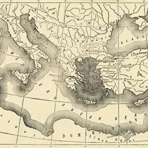
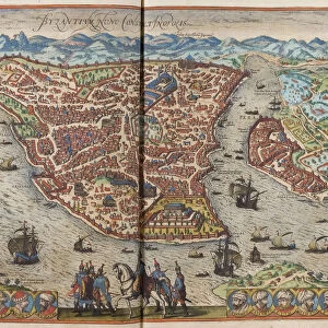
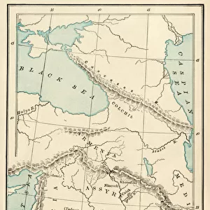
Byzantine and Crusaders v. Seljuks, circa 1130 A.D. c1915. Map of civilisations in the Middle East during the 12th century: Byzantine, other Christian states, Abbasid Caliphate, Seljuks, Fatimids. Also showing the route of the first crusade 1096-1099, the eastern Mediterranean, Red Sea, Caspian Sea, Black Sea and Persian Gulf. From " The Caliphs Last Heritage, a short history of the Turkish Empire" by Lt.-Col. Sir Mark Sykes. [Macmillan & Co, London, 1915]
Heritage Images features heritage image collections
Media ID 19658797
© The Print Collector/Heritage Images
6th Baronet Abbasid Caliphate Arabia Asia Minor Black Sea Boutall Boutall Walker Byzantine Empire Byzantium Caliphate Caspian Sea Cockerell Cockerell Walker Colonel Sir Tatton Benvenuto Mark Sykes Crusades Emery Emery Walker Limited Emery Walker Ltd Fatimid Dynasty Iran Iraq Islamic State Lieutenant Colonel Sir Mark Sykes Macmillan Macmillan And Co Macmillan Publishers Macmillan Publishers Ltd Mark Mark Sykes Mediterranean Sea Ottoman Empire Palestine Persia Persian Gulf Persian Gulf Asia Publishers Macmillan Seljuk Empire Sir Mark Sykes State Sykes Sykes Mark Sykes Mark Sir Sykes Tatton Benvenuto Mark Syria Tatton Benvenuto Mark Tatton Benvenuto Mark Sykes Turkey Turkish Walker Walker Amp Walker And Boutall Walker And Cockerell Walker Boutall Walker Cockerell Walker Emery Ltd
20"x16" (+3" Border) Fine Art Print
Step back in time with our exquisite Fine Art Print from Media Storehouse, featuring the captivating map "Byzantine and Crusaders v. Seljuks, circa 1130 A.D." by Emery Walker Ltd. This historic map transports you to the Middle East during the 12th century, showcasing the major civilizations of the time: the Byzantine Empire, various Christian states, the Abbasid Caliphate, the Seljuks, and the Fatimids. With intricate detail and stunning accuracy, this print is a must-have for history enthusiasts, educators, and anyone with an appreciation for the rich cultural heritage of the past. Bring this piece of history into your home or office and let it inspire and intrigue you every day.
20x16 image printed on 26x22 Fine Art Rag Paper with 3" (76mm) white border. Our Fine Art Prints are printed on 300gsm 100% acid free, PH neutral paper with archival properties. This printing method is used by museums and art collections to exhibit photographs and art reproductions.
Our fine art prints are high-quality prints made using a paper called Photo Rag. This 100% cotton rag fibre paper is known for its exceptional image sharpness, rich colors, and high level of detail, making it a popular choice for professional photographers and artists. Photo rag paper is our clear recommendation for a fine art paper print. If you can afford to spend more on a higher quality paper, then Photo Rag is our clear recommendation for a fine art paper print.
Estimated Image Size (if not cropped) is 47.8cm x 40.6cm (18.8" x 16")
Estimated Product Size is 66cm x 55.9cm (26" x 22")
These are individually made so all sizes are approximate
Artwork printed orientated as per the preview above, with landscape (horizontal) orientation to match the source image.
FEATURES IN THESE COLLECTIONS
> Arts
> Artists
> S
> Syrian Syrian
> Asia
> Iran
> Lakes
> Caspian Sea
> Asia
> Iran
> Related Images
> Asia
> Iraq
> Related Images
> Asia
> Palestine
> Related Images
> Asia
> Syria
> Related Images
EDITORS COMMENTS
This print titled "Byzantine and Crusaders v. Seljuks, circa 1130 A. D" takes us back to the rich history of the Middle East during the 12th century. Created by Emery Walker Ltd in 1915, this map showcases the diverse civilizations that coexisted in this region at that time. The intricate details on this map allow us to trace the route of the first crusade from 1096 to 1099, highlighting significant locations such as the eastern Mediterranean, Red Sea, Caspian Sea, Black Sea, and Persian Gulf. It also depicts various empires and states including Byzantine Empire, other Christian states, Abbasid Caliphate, Seljuks, and Fatimids. Lt. -Col. Sir Mark Sykes' book "The Caliphs Last Heritage: a short history of the Turkish Empire" serves as an invaluable source for understanding this period's geopolitical landscape. Published by Macmillan & Co in London in 1915. Through its vibrant colors and meticulous cartography work by Cockerell Walker Boutall (Cockerell Walker Boutall was not mentioned), this print transports us back to a time when religion played a pivotal role in shaping societies across these lands. Emery Walker Ltd has beautifully captured an era where empires clashed and cultures intertwined against a backdrop of political power struggles and religious fervor. This image is not only visually stunning but also serves as a historical testament to our shared past in one of humanity's most intriguing regions - The Middle East.
MADE IN THE USA
Safe Shipping with 30 Day Money Back Guarantee
FREE PERSONALISATION*
We are proud to offer a range of customisation features including Personalised Captions, Color Filters and Picture Zoom Tools
SECURE PAYMENTS
We happily accept a wide range of payment options so you can pay for the things you need in the way that is most convenient for you
* Options may vary by product and licensing agreement. Zoomed Pictures can be adjusted in the Cart.