Fine Art Print > Europe > United Kingdom > England > Warwickshire > Related Images
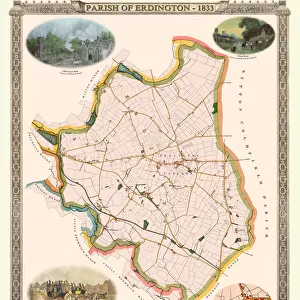
Fine Art Print : Old Map of The Manor of Erdington in Warwickshire 1760


![]()
Fine Art Prints from MapSeeker
Old Map of The Manor of Erdington in Warwickshire 1760
PL064
Welcome to the Mapseeker Image library and enter an historic gateway to one of the largest on-line collections of Historic Maps, Nostalgic Views, Vista's and Panorama's from a World gone by.
Media ID 20347333
Historic Map Old Town Plan Town Plan Erdington
20"x16" (+3" Border) Fine Art Print
Step back in time with our exquisite Old Map of The Manor of Erdington in Warwickshire from MapSeeker, part of the Media Storehouse Fine Art Prints collection. This beautifully detailed antique map, dated 1760, transports you to a bygone era with its intricate depiction of the Manor and its surroundings. A perfect addition to any home or office, this fine art print is not only a decorative piece but also a glimpse into history. Bring the rich heritage of Warwickshire into your space and elevate your interior design with this timeless and captivating piece.
20x16 image printed on 26x22 Fine Art Rag Paper with 3" (76mm) white border. Our Fine Art Prints are printed on 300gsm 100% acid free, PH neutral paper with archival properties. This printing method is used by museums and art collections to exhibit photographs and art reproductions.
Our fine art prints are high-quality prints made using a paper called Photo Rag. This 100% cotton rag fibre paper is known for its exceptional image sharpness, rich colors, and high level of detail, making it a popular choice for professional photographers and artists. Photo rag paper is our clear recommendation for a fine art paper print. If you can afford to spend more on a higher quality paper, then Photo Rag is our clear recommendation for a fine art paper print.
Estimated Image Size (if not cropped) is 40.6cm x 50.8cm (16" x 20")
Estimated Product Size is 55.9cm x 66cm (22" x 26")
These are individually made so all sizes are approximate
Artwork printed orientated as per the preview above, with portrait (vertical) orientation to match the source image.
FEATURES IN THESE COLLECTIONS
> Europe
> United Kingdom
> England
> Warwickshire
> Related Images
> MapSeeker
> British Town And City Plans
> English & Welsh PORTFOLIO
EDITORS COMMENTS
This print showcases the "Old Map of The Manor of Erdington in Warwickshire 1760 (PL064)". With its intricate details and historical significance, this map offers a fascinating glimpse into the past. The image transports us back to the year 1760, where we can explore the charming village of Erdington as it once was. This meticulously crafted town plan provides a comprehensive overview of the area, capturing every street, building, and landmark with remarkable precision. As we examine this historic map, we are reminded of Erdington's rich heritage and its importance within Warwickshire. The village itself exudes an old-world charm that is beautifully depicted through this vintage cartographic gem. Every line on this map tells a story - from the winding roads that connect different parts of Erdington to the clusters of houses nestled amidst lush greenery. It allows us to imagine what life was like for residents during that era; their daily routines and interactions within this tight-knit community. Whether you have personal ties to Erdington or simply appreciate historical maps, this print serves as a window into another time. Its aesthetic appeal combined with its educational value makes it an ideal addition to any history enthusiast's collection
MADE IN THE USA
Safe Shipping with 30 Day Money Back Guarantee
FREE PERSONALISATION*
We are proud to offer a range of customisation features including Personalised Captions, Color Filters and Picture Zoom Tools
SECURE PAYMENTS
We happily accept a wide range of payment options so you can pay for the things you need in the way that is most convenient for you
* Options may vary by product and licensing agreement. Zoomed Pictures can be adjusted in the Cart.