Framed Print > Europe > United Kingdom > England > Warwickshire > Related Images
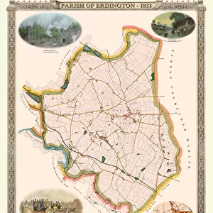
Framed Print : Old Map of The Manor of Erdington in Warwickshire 1760


![]()
Framed Photos from MapSeeker
Old Map of The Manor of Erdington in Warwickshire 1760
PL064
Welcome to the Mapseeker Image library and enter an historic gateway to one of the largest on-line collections of Historic Maps, Nostalgic Views, Vista's and Panorama's from a World gone by.
Media ID 20347333
Historic Map Old Town Plan Town Plan Erdington
12"x10" Modern Frame
Step back in time with our exquisite Framed Print from the Media Storehouse collection. Featuring an Old Map of The Manor of Erdington in Warwickshire, dated 1760, sourced from MapSeeker. Each print is meticulously framed in a classic design, adding an air of timeless elegance to any room. This detailed map offers a unique glimpse into history, making it a wonderful addition to your home or office. Order now and let this beautiful piece transport you on a journey through the past.
10x8 Print in an MDF Wooden Frame with 180 gsm Satin Finish Paper. Glazed using shatter proof thin plexi glass. Frame thickness is 1 inch and depth 0.75 inch. Fluted cardboard backing held with clips. Supplied ready to hang with sawtooth hanger and rubber bumpers. Spot clean with a damp cloth. Packaged foam wrapped in a card.
Contemporary Framed and Mounted Prints - Professionally Made and Ready to Hang
Estimated Image Size (if not cropped) is 25.4cm x 25.4cm (10" x 10")
Estimated Product Size is 25.4cm x 30.5cm (10" x 12")
These are individually made so all sizes are approximate
Artwork printed orientated as per the preview above, with landscape (horizontal) or portrait (vertical) orientation to match the source image.
FEATURES IN THESE COLLECTIONS
> Europe
> United Kingdom
> England
> Warwickshire
> Related Images
> MapSeeker
> British Town And City Plans
> English & Welsh PORTFOLIO
EDITORS COMMENTS
This print showcases the "Old Map of The Manor of Erdington in Warwickshire 1760 (PL064)". With its intricate details and historical significance, this map offers a fascinating glimpse into the past. The image transports us back to the year 1760, where we can explore the charming village of Erdington as it once was. This meticulously crafted town plan provides a comprehensive overview of the area, capturing every street, building, and landmark with remarkable precision. As we examine this historic map, we are reminded of Erdington's rich heritage and its importance within Warwickshire. The village itself exudes an old-world charm that is beautifully depicted through this vintage cartographic gem. Every line on this map tells a story - from the winding roads that connect different parts of Erdington to the clusters of houses nestled amidst lush greenery. It allows us to imagine what life was like for residents during that era; their daily routines and interactions within this tight-knit community. Whether you have personal ties to Erdington or simply appreciate historical maps, this print serves as a window into another time. Its aesthetic appeal combined with its educational value makes it an ideal addition to any history enthusiast's collection
MADE IN THE USA
Safe Shipping with 30 Day Money Back Guarantee
FREE PERSONALISATION*
We are proud to offer a range of customisation features including Personalised Captions, Color Filters and Picture Zoom Tools
SECURE PAYMENTS
We happily accept a wide range of payment options so you can pay for the things you need in the way that is most convenient for you
* Options may vary by product and licensing agreement. Zoomed Pictures can be adjusted in the Cart.