Fine Art Print > Europe > United Kingdom > England > London > River Thames
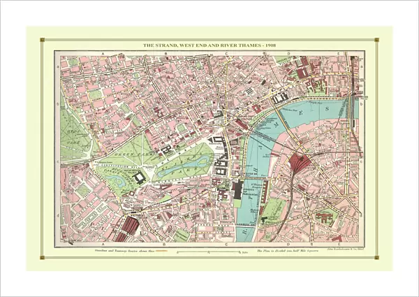
Fine Art Print : Old Street Map of The Strand, West End and River Thames 1908


![]()
Fine Art Prints from MapSeeker
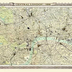
Old Street Map of The Strand, West End and River Thames 1908
Detailed colour Street Plan of London from 1908 covering the area around The Strand, The West End and the River Thames.The image has been remastered from Bartholomews Handy Atlas of London and Suburbs 1908
Welcome to the Mapseeker Image library and enter an historic gateway to one of the largest on-line collections of Historic Maps, Nostalgic Views, Vista's and Panorama's from a World gone by.
Media ID 20347773
© Mapseeker Publishing Ltd, Collins Bartholomew Ltd
London Map London Street Plan Map Of Central London Map Of London Old London Street Map Old Map Of London Central Street Map Of London Street Plan Strand The Strand West End
21"x14" (+3" Border) Fine Art Print
Step back in time with our exquisite Old Street Map of The Strand, West End and River Thames 1908 by John Bartholomew from MapSeeker Publishing. This Fine Art Print, taken from the Collins Bartholomew Mapseeker Publishing's Handy Atlas of London, showcases a detailed and vibrant colour Street Plan of London from 1908. The image has been meticulously remastered, preserving the historical charm of the map while enhancing its visual appeal. Perfect for adding a touch of history and character to your home or office decor. Explore the rich history of London through this stunning piece of cartographic art.
21x14 image printed on 27x20 Fine Art Rag Paper with 3" (76mm) white border. Our Fine Art Prints are printed on 300gsm 100% acid free, PH neutral paper with archival properties. This printing method is used by museums and art collections to exhibit photographs and art reproductions.
Our fine art prints are high-quality prints made using a paper called Photo Rag. This 100% cotton rag fibre paper is known for its exceptional image sharpness, rich colors, and high level of detail, making it a popular choice for professional photographers and artists. Photo rag paper is our clear recommendation for a fine art paper print. If you can afford to spend more on a higher quality paper, then Photo Rag is our clear recommendation for a fine art paper print.
Estimated Image Size (if not cropped) is 53.3cm x 35.5cm (21" x 14")
Estimated Product Size is 68.6cm x 50.8cm (27" x 20")
These are individually made so all sizes are approximate
Artwork printed orientated as per the preview above, with landscape (horizontal) orientation to match the source image.
FEATURES IN THESE COLLECTIONS
> Arts
> Photorealistic artworks
> Detailed art pieces
> Masterful detailing in art
> Europe
> United Kingdom
> England
> London
> River Thames
> Maps and Charts
> Related Images
> MapSeeker
> British Town And City Plans
> English & Welsh PORTFOLIO
EDITORS COMMENTS
This beautifully remastered print takes us back in time to the bustling streets of London in 1908. The Old Street Map of The Strand, West End, and River Thames offers a detailed and colorful street plan that captures the essence of this vibrant city. As we gaze upon this historical treasure, we are transported to an era when horse-drawn carriages traversed the cobbled streets and gas lamps illuminated the way. The map showcases not only the iconic landmarks but also provides a glimpse into everyday life during that period. John Bartholomew's expertise is evident in his meticulous attention to detail, allowing us to explore every nook and cranny of central London. From The Strand with its grand theaters and hotels to the renowned West End district known for its entertainment scene, this map reveals a thriving metropolis at its prime. The River Thames gracefully winds through the heart of London, serving as both a transportation hub and a picturesque backdrop for countless stories. Its presence on this map reminds us of how integral it was to daily life in early 20th century London. Whether you are an avid history enthusiast or simply curious about how our beloved city has evolved over time, this old street map is sure to captivate your imagination. It serves as a testament to London's rich heritage while offering endless opportunities for exploration within its intricate web of streets and avenues.
MADE IN THE USA
Safe Shipping with 30 Day Money Back Guarantee
FREE PERSONALISATION*
We are proud to offer a range of customisation features including Personalised Captions, Color Filters and Picture Zoom Tools
SECURE PAYMENTS
We happily accept a wide range of payment options so you can pay for the things you need in the way that is most convenient for you
* Options may vary by product and licensing agreement. Zoomed Pictures can be adjusted in the Cart.