Fine Art Print > Europe > United Kingdom > Scotland > Highlands > Inverness
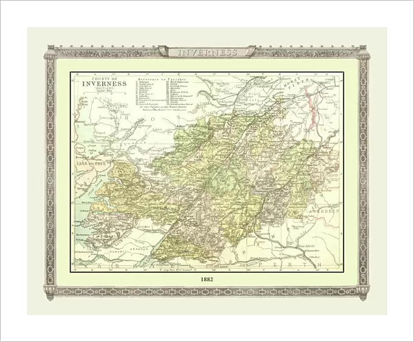
Fine Art Print : Old Map of the County of Inverness from the Philips Handy Atlas of 1882


![]()
Fine Art Prints from MapSeeker
Old Map of the County of Inverness from the Philips Handy Atlas of 1882
PHA017
Welcome to the Mapseeker Image library and enter an historic gateway to one of the largest on-line collections of Historic Maps, Nostalgic Views, Vista's and Panorama's from a World gone by.
Media ID 20348189
County Map County Map Of Scotland Historic Map Old County Map Old Scottish County Map Scottish County Map Inverness Inverness Shire
20"x16" (+3" Border) Fine Art Print
Step back in time with our exquisite Old Map of Inverness from the Philips Handy Atlas of 1882. Part of the Media Storehouse Fine Art Prints collection, this beautifully detailed map transports you to a bygone era. Meticulously reproduced from the original map, the intricate lines and vibrant colors bring the County of Inverness to life. A perfect addition to any home or office, this fine art print is a captivating conversation starter and a beautiful reminder of the rich history and heritage of Inverness.
20x16 image printed on 26x22 Fine Art Rag Paper with 3" (76mm) white border. Our Fine Art Prints are printed on 300gsm 100% acid free, PH neutral paper with archival properties. This printing method is used by museums and art collections to exhibit photographs and art reproductions.
Our fine art prints are high-quality prints made using a paper called Photo Rag. This 100% cotton rag fibre paper is known for its exceptional image sharpness, rich colors, and high level of detail, making it a popular choice for professional photographers and artists. Photo rag paper is our clear recommendation for a fine art paper print. If you can afford to spend more on a higher quality paper, then Photo Rag is our clear recommendation for a fine art paper print.
Estimated Image Size (if not cropped) is 50.8cm x 40.6cm (20" x 16")
Estimated Product Size is 66cm x 55.9cm (26" x 22")
These are individually made so all sizes are approximate
Artwork printed orientated as per the preview above, with landscape (horizontal) orientation to match the source image.
FEATURES IN THESE COLLECTIONS
> Europe
> United Kingdom
> Scotland
> Highlands
> Inverness
> Europe
> United Kingdom
> Scotland
> Inverness-shire
> Europe
> United Kingdom
> Scotland
> Inverness
> Europe
> United Kingdom
> Scotland
> Maps
> Maps and Charts
> Early Maps
> Maps and Charts
> Related Images
> MapSeeker
> Maps from the British Isles
> Scotland and Counties PORTFOLIO
EDITORS COMMENTS
This print showcases an exquisite piece of history - the Old Map of the County of Inverness from the Philips Handy Atlas of 1882. Steeped in Scottish heritage, this vintage map offers a glimpse into the past, transporting us to a bygone era. With its intricate details and delicate craftsmanship, this old Scottish county map is a testament to cartographic artistry. Every contour and curve tells a story, revealing the rich tapestry that is Inverness County's landscape. From rolling hills to winding rivers, each feature is meticulously depicted, inviting exploration and discovery. As we delve into this historic map of Inverness, we are transported back in time. We can almost imagine ourselves traversing through ancient villages and bustling marketplaces that once thrived within these borders. The names etched upon the map evoke nostalgia for forgotten times - reminding us of generations long gone but not forgotten. Inverness Shire comes alive before our eyes as we study this remarkable artifact. Its historical significance becomes apparent as we trace its boundaries and contemplate how it has evolved over centuries. Whether you have ancestral ties to this enchanting region or simply appreciate its cultural legacy, this old county map serves as both an educational resource and a stunning piece of artwork. It allows us to connect with our roots while marveling at the ingenuity behind early cartography. Displaying this remarkable print in your home or office will undoubtedly spark conversations about Scotland's past and ignite curiosity about Inverness' vibrant history
MADE IN THE USA
Safe Shipping with 30 Day Money Back Guarantee
FREE PERSONALISATION*
We are proud to offer a range of customisation features including Personalised Captions, Color Filters and Picture Zoom Tools
SECURE PAYMENTS
We happily accept a wide range of payment options so you can pay for the things you need in the way that is most convenient for you
* Options may vary by product and licensing agreement. Zoomed Pictures can be adjusted in the Cart.