Jigsaw Puzzle > Europe > United Kingdom > Scotland > Highlands > Inverness
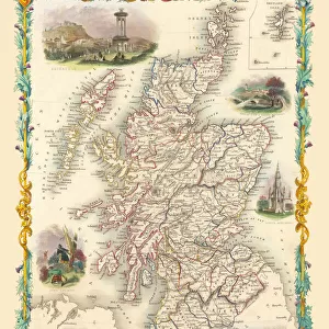
Jigsaw Puzzle : Old Map of the County of Inverness from the Philips Handy Atlas of 1882


![]()
Jigsaw Puzzles from MapSeeker
Old Map of the County of Inverness from the Philips Handy Atlas of 1882
PHA017
Welcome to the Mapseeker Image library and enter an historic gateway to one of the largest on-line collections of Historic Maps, Nostalgic Views, Vista's and Panorama's from a World gone by.
Media ID 20348189
County Map County Map Of Scotland Historic Map Old County Map Old Scottish County Map Scottish County Map Inverness Inverness Shire
Jigsaw Puzzle (520 Pieces)
Discover the charm of the past with Media Storehouse's Jigsaw Puzzle featuring an Old Map of Inverness County from the Philips Handy Atlas of 1882. This intricately detailed puzzle brings history to life, allowing you to explore the County of Inverness as it appeared over a century ago. The vintage map design is sure to captivate puzzle enthusiasts and history buffs alike. Engage your mind, challenge your problem-solving skills, and step back in time with this captivating jigsaw puzzle from Media Storehouse.
Made in the USA, 520-piece puzzles measure 16" x 20" (40.6 x 50.8 cm). Every puzzle is meticulously printed on glossy photo paper, which has a strong 1.33 mm thickness. Delivered in a black storage cardboard box, these puzzles are both stylish and practical. (Note: puzzles contain small parts and are not suitable for children under 3 years of age.)
Jigsaw Puzzles are an ideal gift for any occasion
Estimated Product Size is 50.8cm x 40.5cm (20" x 15.9")
These are individually made so all sizes are approximate
Artwork printed orientated as per the preview above, with landscape (horizontal) or portrait (vertical) orientation to match the source image.
FEATURES IN THESE COLLECTIONS
> Europe
> United Kingdom
> Scotland
> Highlands
> Inverness
> Europe
> United Kingdom
> Scotland
> Inverness-shire
> Europe
> United Kingdom
> Scotland
> Inverness
> Europe
> United Kingdom
> Scotland
> Maps
> Maps and Charts
> Early Maps
> Maps and Charts
> Related Images
> MapSeeker
> Maps from the British Isles
> Scotland and Counties PORTFOLIO
EDITORS COMMENTS
This print showcases an exquisite piece of history - the Old Map of the County of Inverness from the Philips Handy Atlas of 1882. Steeped in Scottish heritage, this vintage map offers a glimpse into the past, transporting us to a bygone era. With its intricate details and delicate craftsmanship, this old Scottish county map is a testament to cartographic artistry. Every contour and curve tells a story, revealing the rich tapestry that is Inverness County's landscape. From rolling hills to winding rivers, each feature is meticulously depicted, inviting exploration and discovery. As we delve into this historic map of Inverness, we are transported back in time. We can almost imagine ourselves traversing through ancient villages and bustling marketplaces that once thrived within these borders. The names etched upon the map evoke nostalgia for forgotten times - reminding us of generations long gone but not forgotten. Inverness Shire comes alive before our eyes as we study this remarkable artifact. Its historical significance becomes apparent as we trace its boundaries and contemplate how it has evolved over centuries. Whether you have ancestral ties to this enchanting region or simply appreciate its cultural legacy, this old county map serves as both an educational resource and a stunning piece of artwork. It allows us to connect with our roots while marveling at the ingenuity behind early cartography. Displaying this remarkable print in your home or office will undoubtedly spark conversations about Scotland's past and ignite curiosity about Inverness' vibrant history
MADE IN THE USA
Safe Shipping with 30 Day Money Back Guarantee
FREE PERSONALISATION*
We are proud to offer a range of customisation features including Personalised Captions, Color Filters and Picture Zoom Tools
SECURE PAYMENTS
We happily accept a wide range of payment options so you can pay for the things you need in the way that is most convenient for you
* Options may vary by product and licensing agreement. Zoomed Pictures can be adjusted in the Cart.