Fine Art Print > Maps and Charts > World
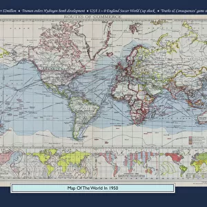
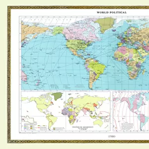
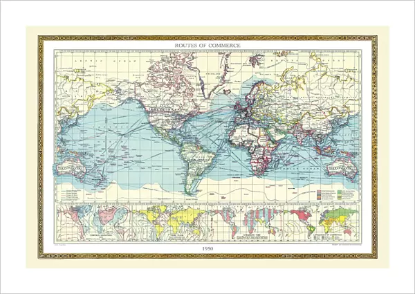
Fine Art Print : Old Map of the World 1950


![]()
Fine Art Prints from MapSeeker
Old Map of the World 1950
WMY1950
Welcome to the Mapseeker Image library and enter an historic gateway to one of the largest on-line collections of Historic Maps, Nostalgic Views, Vista's and Panorama's from a World gone by.
Media ID 20347537
Map Of The World Old Map Of The World The World World Map
21"x14" (+3" Border) Fine Art Print
21x14 image printed on 27x20 Fine Art Rag Paper with 3" (76mm) white border. Our Fine Art Prints are printed on 300gsm 100% acid free, PH neutral paper with archival properties. This printing method is used by museums and art collections to exhibit photographs and art reproductions.
Our fine art prints are high-quality prints made using a paper called Photo Rag. This 100% cotton rag fibre paper is known for its exceptional image sharpness, rich colors, and high level of detail, making it a popular choice for professional photographers and artists. Photo rag paper is our clear recommendation for a fine art paper print. If you can afford to spend more on a higher quality paper, then Photo Rag is our clear recommendation for a fine art paper print.
Estimated Image Size (if not cropped) is 53.3cm x 35.5cm (21" x 14")
Estimated Product Size is 68.6cm x 50.8cm (27" x 20")
These are individually made so all sizes are approximate
Artwork printed orientated as per the preview above, with landscape (horizontal) orientation to match the source image.
FEATURES IN THESE COLLECTIONS
> Maps and Charts
> Related Images
> Maps and Charts
> World
> MapSeeker
> Maps Showing the World
> Maps of The World by Year PORTFOLIO
EDITORS COMMENTS
This print showcases the "Old Map of the World 1950 (WMY1950)" from MapSeeker, taking us on a nostalgic journey through time. The intricate details and vintage charm of this map instantly transport us to an era when exploration and discovery were at their peak. As we gaze upon this remarkable piece, we are reminded of how our perception of the world has evolved over the years. The carefully drawn continents, oceans, and countries reflect a bygone era when cartography was both an art form and a scientific endeavor. Each line tells a story, tracing the paths taken by intrepid explorers who ventured into uncharted territories with nothing but curiosity as their guide. The sepia tones lend an air of antiquity to this print, evoking feelings of wonderment and nostalgia. It serves as a reminder that our planet is vast and diverse, filled with countless cultures waiting to be explored. This old map not only represents geographical boundaries but also symbolizes humanity's insatiable thirst for knowledge about our surroundings. Whether displayed in a study or living room, this print sparks conversations about history, geography, and human progress. It invites us to ponder how far we have come since 1950 while appreciating the beauty inherent in maps as windows into different worlds. MapSeeker's "Old Map of the World 1950" is more than just decorative; it is a testament to our collective fascination with understanding our place in this ever-changing world.
MADE IN THE USA
Safe Shipping with 30 Day Money Back Guarantee
FREE PERSONALISATION*
We are proud to offer a range of customisation features including Personalised Captions, Color Filters and Picture Zoom Tools
SECURE PAYMENTS
We happily accept a wide range of payment options so you can pay for the things you need in the way that is most convenient for you
* Options may vary by product and licensing agreement. Zoomed Pictures can be adjusted in the Cart.