Fine Art Print > Historic > Battles > Battle of Normandy (D-Day) > Battle of Normandy
Fine Art Print : D-DAY MAP 1944


![]()
Fine Art Prints from Mary Evans Picture Library
D-DAY MAP 1944
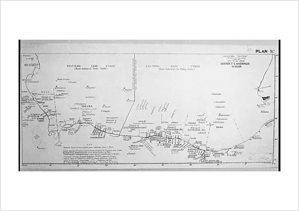
Plan 1C - Operation Neptune, an elaborate map detailing the proposed D-Day Normandy assault landings by Allied troops on the French beaches. Date: June 1944
Mary Evans Picture Library makes available wonderful images created for people to enjoy over the centuries
Media ID 32089269
© Mary Evans Picture Library
1944 Allied Assault Beaches Detailing Elaborate Landings Neptune Normandy Operation Plan Proposed
21"x14" (+3" Border) Fine Art Print
Step back in time with our exquisite D-Day Map 1944 print from the Media Storehouse Fine Art Prints collection. This captivating piece, sourced from Mary Evans Prints Online, offers a fascinating glimpse into history with an intricate depiction of Operation Neptune's proposed Normandy assault landings (Plan 1C). Dated June 1944, this detailed map illustrates the meticulous planning behind the D-Day invasion, a turning point in World War II. Bring history into your home or office with this beautiful and historically significant fine art print.
21x14 image printed on 27x20 Fine Art Rag Paper with 3" (76mm) white border. Our Fine Art Prints are printed on 300gsm 100% acid free, PH neutral paper with archival properties. This printing method is used by museums and art collections to exhibit photographs and art reproductions.
Our fine art prints are high-quality prints made using a paper called Photo Rag. This 100% cotton rag fibre paper is known for its exceptional image sharpness, rich colors, and high level of detail, making it a popular choice for professional photographers and artists. Photo rag paper is our clear recommendation for a fine art paper print. If you can afford to spend more on a higher quality paper, then Photo Rag is our clear recommendation for a fine art paper print.
Estimated Image Size (if not cropped) is 53.3cm x 27cm (21" x 10.6")
Estimated Product Size is 68.6cm x 50.8cm (27" x 20")
These are individually made so all sizes are approximate
Artwork printed orientated as per the preview above, with landscape (horizontal) orientation to match the source image.
FEATURES IN THESE COLLECTIONS
> Animals
> Mammals
> Muridae
> Western Mouse
> Historic
> Battles
> Battle of Normandy (D-Day)
> Battle of Normandy
> Historic
> World War I and II
> Historical events
> Maps and Charts
> Early Maps
> Maps and Charts
> Popular Maps
> Maps and Charts
> Related Images
> Maps and Charts
> World
EDITORS COMMENTS
This incredible print of the D-Day Map from 1944 offers a detailed look at Plan 1C - Operation Neptune, which outlined the Allied troops' proposed assault landings on the French beaches during World War II. The map, created in June of that pivotal year, played a crucial role in one of the most significant events in modern history.
The elaborate detailing on this map showcases the strategic planning and coordination required for such a massive military operation. It serves as a reminder of the bravery and sacrifice exhibited by those who took part in the Normandy invasion.
As we reflect on this piece of history, we are transported back to a time when the fate of Western Europe hung in the balance. The events depicted on this map laid the groundwork for turning the tide against tyranny and oppression.
This print is not just a representation of lines and symbols; it is a tangible connection to our past and a testament to human resilience and determination. It stands as a tribute to all those who fought and died for freedom on that fateful day in June 1944.
MADE IN THE USA
Safe Shipping with 30 Day Money Back Guarantee
FREE PERSONALISATION*
We are proud to offer a range of customisation features including Personalised Captions, Color Filters and Picture Zoom Tools
SECURE PAYMENTS
We happily accept a wide range of payment options so you can pay for the things you need in the way that is most convenient for you
* Options may vary by product and licensing agreement. Zoomed Pictures can be adjusted in the Cart.