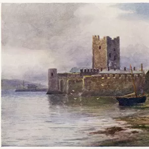
Photo Mug > Historic > Battles > Battle of Normandy (D-Day) > Battle of Normandy
Photo Mug : D-DAY MAP 1944


![]()
Home Decor from Mary Evans Picture Library
D-DAY MAP 1944
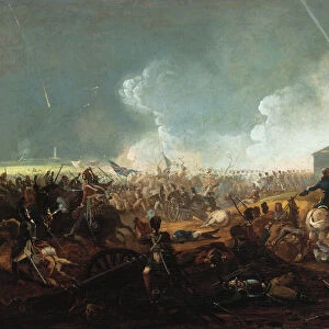
Plan 1C - Operation Neptune, an elaborate map detailing the proposed D-Day Normandy assault landings by Allied troops on the French beaches. Date: June 1944
Mary Evans Picture Library makes available wonderful images created for people to enjoy over the centuries
Media ID 32089269
© Mary Evans Picture Library
1944 Allied Assault Beaches Detailing Elaborate Landings Neptune Normandy Operation Plan Proposed
Large Photo Mug (15 oz)
Introducing the Media Storehouse Photo Mug featuring the historic "D-Day Map 1944" by Rights Managed from Mary Evans Prints Online. This collectible mug showcases an intricate and detailed plan of Operation Neptune, the elaborate map outlining the proposed Normandy assault landings by Allied troops on the French beaches in June 1944. Relive history with every sip from this high-quality mug, perfect for history enthusiasts and collectors alike. Embrace the rich past with this unique and captivating design.
Elevate your coffee or tea experience with our premium white ceramic mug. Its wide, comfortable handle makes drinking easy, and you can rely on it to be both microwave and dishwasher safe. Sold in single units, preview may show both sides of the same mug so you can see how the picture wraps around.
Elevate your coffee or tea experience with our premium white ceramic mug. Its wide, comfortable handle makes drinking easy, and you can rely on it to be both microwave and dishwasher safe. Sold in single units, preview may show both sides of the same mug so you can see how the picture wraps around.
These are individually made so all sizes are approximate
FEATURES IN THESE COLLECTIONS
> Animals
> Mammals
> Muridae
> Western Mouse
> Historic
> Battles
> Battle of Normandy (D-Day)
> Battle of Normandy
> Historic
> World War I and II
> Historical events
> Maps and Charts
> Early Maps
> Maps and Charts
> Popular Maps
> Maps and Charts
> Related Images
> Maps and Charts
> World
EDITORS COMMENTS
This incredible print of the D-Day Map from 1944 offers a detailed look at Plan 1C - Operation Neptune, which outlined the Allied troops' proposed assault landings on the French beaches during World War II. The map, created in June of that pivotal year, played a crucial role in one of the most significant events in modern history.
The elaborate detailing on this map showcases the strategic planning and coordination required for such a massive military operation. It serves as a reminder of the bravery and sacrifice exhibited by those who took part in the Normandy invasion.
As we reflect on this piece of history, we are transported back to a time when the fate of Western Europe hung in the balance. The events depicted on this map laid the groundwork for turning the tide against tyranny and oppression.
This print is not just a representation of lines and symbols; it is a tangible connection to our past and a testament to human resilience and determination. It stands as a tribute to all those who fought and died for freedom on that fateful day in June 1944.
MADE IN THE USA
Safe Shipping with 30 Day Money Back Guarantee
FREE PERSONALISATION*
We are proud to offer a range of customisation features including Personalised Captions, Color Filters and Picture Zoom Tools
SECURE PAYMENTS
We happily accept a wide range of payment options so you can pay for the things you need in the way that is most convenient for you
* Options may vary by product and licensing agreement. Zoomed Pictures can be adjusted in the Cart.