Fine Art Print > Maps and Charts > World
Fine Art Print : Europe Map C1918


![]()
Fine Art Prints from Mary Evans Picture Library
Europe Map C1918
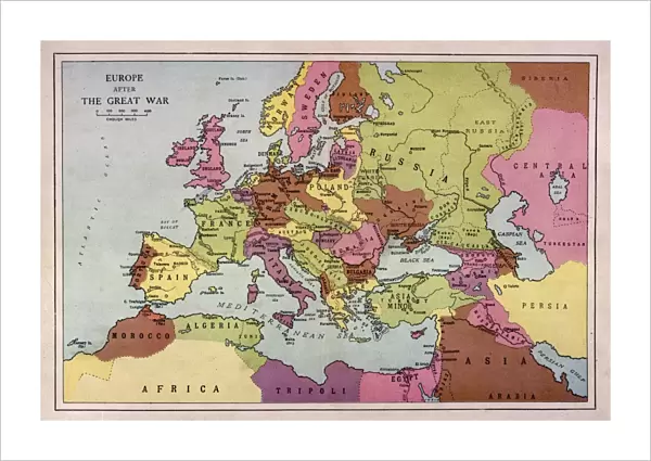
The map of Europe after World War One
Mary Evans Picture Library makes available wonderful images created for people to enjoy over the centuries
Media ID 4315937
© Mary Evans Picture Library 2015 - https://copyrighthub.org/s0/hub1/creation/maryevans/MaryEvansPictureID/10125209
21"x14" (+3" Border) Fine Art Print
Discover the rich history of Europe in the aftermath of World War One with our exquisite Fine Art Prints from Media Storehouse. This captivating map, titled "Europe Map C1918" from Mary Evans Prints Online, offers a fascinating glimpse into a pivotal moment in history. Each print is meticulously produced using high-quality materials, ensuring vibrant colors and exceptional detail. Bring a piece of historical artistry into your home or office and transport yourself on a journey through time with Media Storehouse's Fine Art Prints collection.
21x14 image printed on 27x20 Fine Art Rag Paper with 3" (76mm) white border. Our Fine Art Prints are printed on 300gsm 100% acid free, PH neutral paper with archival properties. This printing method is used by museums and art collections to exhibit photographs and art reproductions.
Our fine art prints are high-quality prints made using a paper called Photo Rag. This 100% cotton rag fibre paper is known for its exceptional image sharpness, rich colors, and high level of detail, making it a popular choice for professional photographers and artists. Photo rag paper is our clear recommendation for a fine art paper print. If you can afford to spend more on a higher quality paper, then Photo Rag is our clear recommendation for a fine art paper print.
Estimated Image Size (if not cropped) is 53.3cm x 35.5cm (21" x 14")
Estimated Product Size is 68.6cm x 50.8cm (27" x 20")
These are individually made so all sizes are approximate
Artwork printed orientated as per the preview above, with landscape (horizontal) orientation to match the source image.
FEATURES IN THESE COLLECTIONS
> Europe
> Related Images
> Maps and Charts
> Early Maps
> Maps and Charts
> Related Images
> Maps and Charts
> World
EDITORS COMMENTS
This striking print of the Europe Map circa 1918 offers a glimpse into the aftermath of World War One, showcasing the significant changes that took place in the continent during this tumultuous period in history. The map is a visual representation of the great upheaval and shifting borders that occurred as a result of the war, with countries being redrawn and redefined.
The intricate details on this historical map provide a fascinating insight into how Europe looked post-World War One, highlighting the political complexities and territorial adjustments that were made at that time. From new nations emerging to old empires crumbling, this map captures a pivotal moment in European history.
As we study this map closely, we can see how different regions were affected by the war and how power dynamics shifted across the continent. It serves as a reminder of the human cost of conflict and the lasting impact it can have on societies and nations.
Overall, this Europe Map c1918 is not just a geographical representation but also a poignant reminder of our shared history and collective memory. It invites us to reflect on past events while also serving as an educational tool for understanding how wars shape our world.
MADE IN THE USA
Safe Shipping with 30 Day Money Back Guarantee
FREE PERSONALISATION*
We are proud to offer a range of customisation features including Personalised Captions, Color Filters and Picture Zoom Tools
SECURE PAYMENTS
We happily accept a wide range of payment options so you can pay for the things you need in the way that is most convenient for you
* Options may vary by product and licensing agreement. Zoomed Pictures can be adjusted in the Cart.