Fine Art Print > Europe > Austria > Maps
Fine Art Print : Map of Central Europe, World War One


![]()
Fine Art Prints from Mary Evans Picture Library
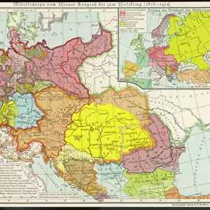
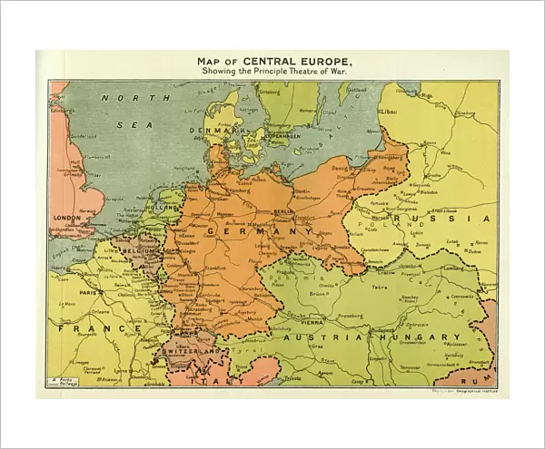
Map of Central Europe, World War One
Map of Central Europe in World War One, showing the Principal Theatre of War. Date: World War One
Mary Evans Picture Library makes available wonderful images created for people to enjoy over the centuries
Media ID 14125848
© Mary Evans Picture Library/PHILIP TALMAGE
Austria Countries Denmark Holland Hungary Maps
20"x16" (+3" Border) Fine Art Print
Discover the historical depth of the past with our exquisite Fine Art Print from Media Storehouse, featuring the Map of Central Europe during World War One from Mary Evans Prints Online. This captivating piece showcases the Principal Theatre of War during this pivotal time in history. Each print is meticulously produced with the highest quality standards, allowing you to bring a piece of the past into your home or office. Perfect for history enthusiasts, educators, or anyone seeking to add a touch of timeless elegance to their space. Order now and let this stunning print transport you back in time.
20x16 image printed on 26x22 Fine Art Rag Paper with 3" (76mm) white border. Our Fine Art Prints are printed on 300gsm 100% acid free, PH neutral paper with archival properties. This printing method is used by museums and art collections to exhibit photographs and art reproductions.
Our fine art prints are high-quality prints made using a paper called Photo Rag. This 100% cotton rag fibre paper is known for its exceptional image sharpness, rich colors, and high level of detail, making it a popular choice for professional photographers and artists. Photo rag paper is our clear recommendation for a fine art paper print. If you can afford to spend more on a higher quality paper, then Photo Rag is our clear recommendation for a fine art paper print.
Estimated Image Size (if not cropped) is 50.8cm x 37.5cm (20" x 14.8")
Estimated Product Size is 66cm x 55.9cm (26" x 22")
These are individually made so all sizes are approximate
Artwork printed orientated as per the preview above, with landscape (horizontal) orientation to match the source image.
FEATURES IN THESE COLLECTIONS
> Europe
> Austria
> Related Images
> Europe
> Belgium
> Related Images
> Europe
> Denmark
> Related Images
EDITORS COMMENTS
This map print depicts Central Europe during the tumultuous period of World War One, from 1914 to 1918. The intricate details of the map reveal the principal theatre of war, with Germany, Austria-Hungary, and their allies occupying the eastern and central parts, while France, Belgium, Holland, and their allies hold the western front. Denmark, situated to the north, remained neutral throughout the conflict. The map serves as a poignant reminder of the complex geopolitical landscape of the time, as well as the devastating impact of the war on European countries. The intricate borders and territorial claims that once defined this region were redrawn, leading to significant political and social upheaval. The map's title, "Map of Central Europe in World War One," is inscribed in elegant script at the top, while the date range, "1914-1918," is displayed prominently at the bottom. The map's historical significance is further emphasized by the use of shading to highlight the various theatres of war and the inclusion of an inset map of the Eastern Front. As we study this map, we are transported back in time to an era of profound change and upheaval. The map serves as a visual testament to the sacrifices made by millions of people during the war, and a reminder of the enduring importance of peace and diplomacy in resolving international conflicts.
MADE IN THE USA
Safe Shipping with 30 Day Money Back Guarantee
FREE PERSONALISATION*
We are proud to offer a range of customisation features including Personalised Captions, Color Filters and Picture Zoom Tools
SECURE PAYMENTS
We happily accept a wide range of payment options so you can pay for the things you need in the way that is most convenient for you
* Options may vary by product and licensing agreement. Zoomed Pictures can be adjusted in the Cart.