Jigsaw Puzzle > Europe > Austria > Maps
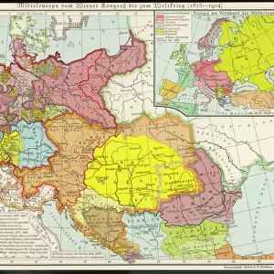
Jigsaw Puzzle : Map of Central Europe, World War One


![]()
Jigsaw Puzzles from Mary Evans Picture Library
Map of Central Europe, World War One
Map of Central Europe in World War One, showing the Principal Theatre of War. Date: World War One
Mary Evans Picture Library makes available wonderful images created for people to enjoy over the centuries
Media ID 14125848
© Mary Evans Picture Library/PHILIP TALMAGE
Austria Countries Denmark Holland Hungary Maps
Jigsaw Puzzle (520 Pieces)
Discover history with our intricately detailed Jigsaw Puzzle from Media Storehouse, featuring a captivating Map of Central Europe during World War One. This historical puzzle, sourced from Mary Evans Prints Online, transports you back in time to the Principal Theatre of War. Immerse yourself in the intricacies of this 100-year-old map, piecing together the geography and events of a pivotal era. Engage your mind, challenge your problem-solving skills, and learn while having fun. Perfect for history enthusiasts, puzzle lovers, or anyone seeking an educational and entertaining activity.
Made in the USA, 520-piece puzzles measure 16" x 20" (40.6 x 50.8 cm). Every puzzle is meticulously printed on glossy photo paper, which has a strong 1.33 mm thickness. Delivered in a black storage cardboard box, these puzzles are both stylish and practical. (Note: puzzles contain small parts and are not suitable for children under 3 years of age.)
Jigsaw Puzzles are an ideal gift for any occasion
Estimated Product Size is 50.8cm x 40.5cm (20" x 15.9")
These are individually made so all sizes are approximate
Artwork printed orientated as per the preview above, with landscape (horizontal) or portrait (vertical) orientation to match the source image.
FEATURES IN THESE COLLECTIONS
> Europe
> Austria
> Related Images
> Europe
> Belgium
> Related Images
> Europe
> Denmark
> Related Images
EDITORS COMMENTS
This map print depicts Central Europe during the tumultuous period of World War One, from 1914 to 1918. The intricate details of the map reveal the principal theatre of war, with Germany, Austria-Hungary, and their allies occupying the eastern and central parts, while France, Belgium, Holland, and their allies hold the western front. Denmark, situated to the north, remained neutral throughout the conflict. The map serves as a poignant reminder of the complex geopolitical landscape of the time, as well as the devastating impact of the war on European countries. The intricate borders and territorial claims that once defined this region were redrawn, leading to significant political and social upheaval. The map's title, "Map of Central Europe in World War One," is inscribed in elegant script at the top, while the date range, "1914-1918," is displayed prominently at the bottom. The map's historical significance is further emphasized by the use of shading to highlight the various theatres of war and the inclusion of an inset map of the Eastern Front. As we study this map, we are transported back in time to an era of profound change and upheaval. The map serves as a visual testament to the sacrifices made by millions of people during the war, and a reminder of the enduring importance of peace and diplomacy in resolving international conflicts.
MADE IN THE USA
Safe Shipping with 30 Day Money Back Guarantee
FREE PERSONALISATION*
We are proud to offer a range of customisation features including Personalised Captions, Color Filters and Picture Zoom Tools
SECURE PAYMENTS
We happily accept a wide range of payment options so you can pay for the things you need in the way that is most convenient for you
* Options may vary by product and licensing agreement. Zoomed Pictures can be adjusted in the Cart.