Fine Art Print > Europe > Portugal > Maps
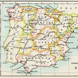
Fine Art Print : Map of the Kingdoms of Spain and Portugal


![]()
Fine Art Prints from Mary Evans Picture Library
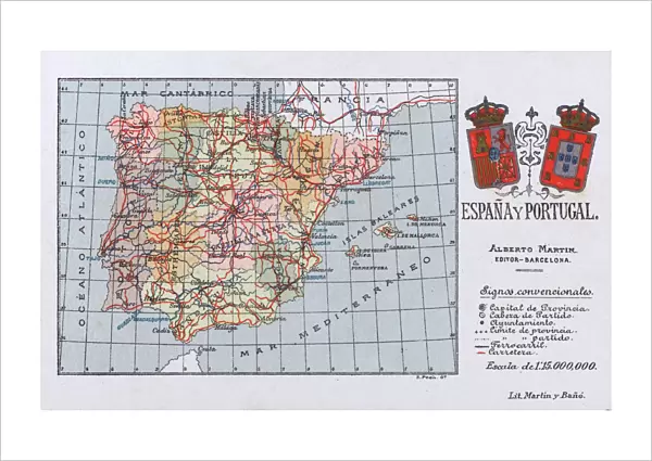
Map of the Kingdoms of Spain and Portugal
Map of the Kingdoms of Spain and Portugal (prior to the Portuguese Revolution in 1910). Date: circa 1908
Mary Evans Picture Library makes available wonderful images created for people to enjoy over the centuries
Media ID 11548861
© Mary Evans / Grenville Collins Postcard Collection
Balearic Borders Ibiza Isalnds Kingdoms Mallorca Mediterranean Menorca Portugal Roads
21"x14" (+3" Border) Fine Art Print
Discover the rich history and cultural heritage of Europe with our exquisite selection of Fine Art Prints from Media Storehouse. This captivating map, titled "Map of the Kingdoms of Spain and Portugal (prior to the Portuguese Revolution in 1910)", is an intriguing glimpse into the past. Dating back to circa 1908, this detailed and beautifully illustrated map showcases the extensive territories of Spain and Portugal during that era. Add this stunning piece to your home or office décor and transport yourself back in time. Each print is sourced from trusted archives, ensuring the highest quality and authenticity. Order now and bring a piece of history into your space.
21x14 image printed on 27x20 Fine Art Rag Paper with 3" (76mm) white border. Our Fine Art Prints are printed on 300gsm 100% acid free, PH neutral paper with archival properties. This printing method is used by museums and art collections to exhibit photographs and art reproductions.
Our fine art prints are high-quality prints made using a paper called Photo Rag. This 100% cotton rag fibre paper is known for its exceptional image sharpness, rich colors, and high level of detail, making it a popular choice for professional photographers and artists. Photo rag paper is our clear recommendation for a fine art paper print. If you can afford to spend more on a higher quality paper, then Photo Rag is our clear recommendation for a fine art paper print.
Estimated Image Size (if not cropped) is 53.3cm x 33.6cm (21" x 13.2")
Estimated Product Size is 68.6cm x 50.8cm (27" x 20")
These are individually made so all sizes are approximate
Artwork printed orientated as per the preview above, with landscape (horizontal) orientation to match the source image.
FEATURES IN THESE COLLECTIONS
> Europe
> Portugal
> Related Images
> Europe
> Spain
> Related Images
> Maps and Charts
> Early Maps
> Maps and Charts
> Related Images
> Maps and Charts
> Spain
MADE IN THE USA
Safe Shipping with 30 Day Money Back Guarantee
FREE PERSONALISATION*
We are proud to offer a range of customisation features including Personalised Captions, Color Filters and Picture Zoom Tools
SECURE PAYMENTS
We happily accept a wide range of payment options so you can pay for the things you need in the way that is most convenient for you
* Options may vary by product and licensing agreement. Zoomed Pictures can be adjusted in the Cart.