Framed Print > Europe > Portugal > Maps
Framed Print : Map of the Kingdoms of Spain and Portugal


![]()
Framed Photos from Mary Evans Picture Library
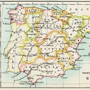
Map of the Kingdoms of Spain and Portugal
Map of the Kingdoms of Spain and Portugal (prior to the Portuguese Revolution in 1910). Date: circa 1908
Mary Evans Picture Library makes available wonderful images created for people to enjoy over the centuries
Media ID 11548861
© Mary Evans / Grenville Collins Postcard Collection
Balearic Borders Ibiza Isalnds Kingdoms Mallorca Mediterranean Menorca Portugal Roads
18"x14" Modern Frame
Discover the rich history of Iberia with our stunning Framed Print of the "Map of the Kingdoms of Spain and Portugal" from the Media Storehouse collection. This exquisite piece, sourced from Mary Evans Prints Online, showcases an intricately detailed map depicting the territories of Spain and Portugal as they existed prior to the Portuguese Revolution in 1910. The map, dated circa 1908, is a captivating representation of the political landscape of the time, making it a perfect addition to any home or office space. Bring history to life with this beautifully framed print, a timeless piece that is sure to ignite curiosity and spark conversation.
16x12 Print in an MDF Wooden Frame with 180 gsm Satin Finish Paper. Glazed using shatter proof thin plexiglass. Frame thickness is 1 inch and depth 0.75 inch. Fluted cardboard backing held with clips. Supplied ready to hang with sawtooth hanger and rubber bumpers. Spot clean with a damp cloth. Packaged foam wrapped in a card.
Contemporary Framed and Mounted Prints - Professionally Made and Ready to Hang
Estimated Image Size (if not cropped) is 40.6cm x 25.6cm (16" x 10.1")
Estimated Product Size is 45.7cm x 35.6cm (18" x 14")
These are individually made so all sizes are approximate
Artwork printed orientated as per the preview above, with landscape (horizontal) orientation to match the source image.
FEATURES IN THESE COLLECTIONS
> Europe
> Portugal
> Related Images
> Europe
> Spain
> Related Images
> Maps and Charts
> Early Maps
> Maps and Charts
> Related Images
> Maps and Charts
> Spain
MADE IN THE USA
Safe Shipping with 30 Day Money Back Guarantee
FREE PERSONALISATION*
We are proud to offer a range of customisation features including Personalised Captions, Color Filters and Picture Zoom Tools
SECURE PAYMENTS
We happily accept a wide range of payment options so you can pay for the things you need in the way that is most convenient for you
* Options may vary by product and licensing agreement. Zoomed Pictures can be adjusted in the Cart.