Fine Art Print > Europe > United Kingdom > England > London > Boroughs > Hackney
Fine Art Print : Map of Victoria Park


![]()
Fine Art Prints from Mary Evans Picture Library
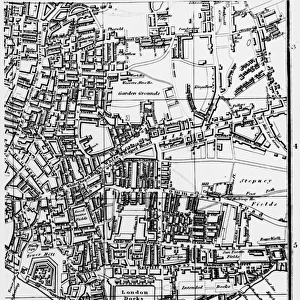
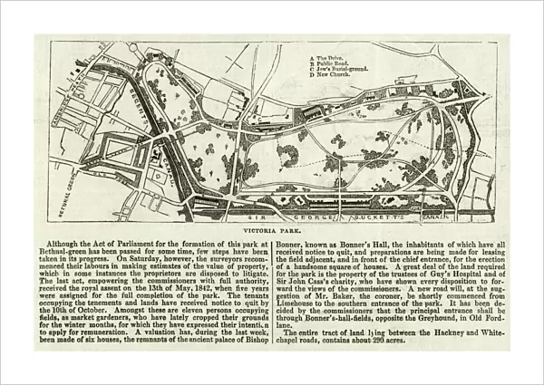
Map of Victoria Park
The proprosed plan of Victoria Park, Bethnal Green. The entire tract of land lying between the Hackney and Whitechapel roads contains about 290 acres
Mary Evans Picture Library makes available wonderful images created for people to enjoy over the centuries
Media ID 4465391
© Mary Evans Picture Library 2015 - https://copyrighthub.org/s0/hub1/creation/maryevans/MaryEvansPictureID/10416262
21"x14" (+3" Border) Fine Art Print
Discover the rich history of Victoria Park with our exquisite Fine Art Print from Media Storehouse, featuring the proposed plan of this iconic London landmark. This beautifully detailed map, sourced from Mary Evans Prints Online, showcases the entire 290-acre expanse of Victoria Park, located between Hackney and Whitechapel roads. Bring a piece of London's past into your home or office with this stunning, high-quality print. Perfect for history enthusiasts, art collectors, or anyone who appreciates the beauty of vintage maps. Order now and transport yourself back in time.
21x14 image printed on 27x20 Fine Art Rag Paper with 3" (76mm) white border. Our Fine Art Prints are printed on 300gsm 100% acid free, PH neutral paper with archival properties. This printing method is used by museums and art collections to exhibit photographs and art reproductions.
Our fine art prints are high-quality prints made using a paper called Photo Rag. This 100% cotton rag fibre paper is known for its exceptional image sharpness, rich colors, and high level of detail, making it a popular choice for professional photographers and artists. Photo rag paper is our clear recommendation for a fine art paper print. If you can afford to spend more on a higher quality paper, then Photo Rag is our clear recommendation for a fine art paper print.
Estimated Image Size (if not cropped) is 53.3cm x 35.5cm (21" x 14")
Estimated Product Size is 68.6cm x 50.8cm (27" x 20")
These are individually made so all sizes are approximate
Artwork printed orientated as per the preview above, with landscape (horizontal) orientation to match the source image.
FEATURES IN THESE COLLECTIONS
> Europe
> France
> Canton
> Landes
> Europe
> United Kingdom
> England
> London
> Boroughs
> Hackney
> Europe
> United Kingdom
> England
> London
> Sights
> Victoria Park
> Maps and Charts
> Early Maps
> Maps and Charts
> Related Images
MADE IN THE USA
Safe Shipping with 30 Day Money Back Guarantee
FREE PERSONALISATION*
We are proud to offer a range of customisation features including Personalised Captions, Color Filters and Picture Zoom Tools
SECURE PAYMENTS
We happily accept a wide range of payment options so you can pay for the things you need in the way that is most convenient for you
* Options may vary by product and licensing agreement. Zoomed Pictures can be adjusted in the Cart.