Framed Print > Europe > United Kingdom > England > London > Boroughs > Hackney
Framed Print : Map of Victoria Park


![]()
Framed Photos from Mary Evans Picture Library
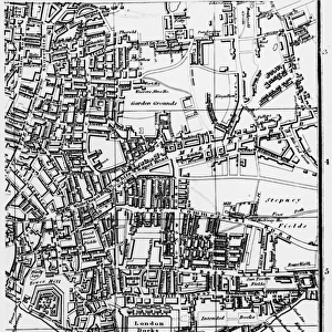
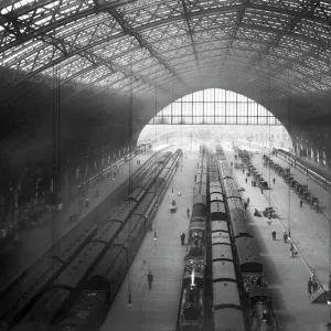
Map of Victoria Park
The proprosed plan of Victoria Park, Bethnal Green. The entire tract of land lying between the Hackney and Whitechapel roads contains about 290 acres
Mary Evans Picture Library makes available wonderful images created for people to enjoy over the centuries
Media ID 4465391
© Mary Evans Picture Library 2015 - https://copyrighthub.org/s0/hub1/creation/maryevans/MaryEvansPictureID/10416262
18"x14" Modern Frame
Introducing the latest addition to our Media Storehouse Framed Prints collection: "Map of Victoria Park" by Rights Managed from Mary Evans Prints Online. This captivating print showcases an historical plan of Victoria Park in Bethnal Green, London, dating back to its proposed layout in the late 1800s. With approximately 290 acres of land nestled between the Hackney and Whitechapel roads, this map offers a fascinating glimpse into the past of this beloved urban green space. Add a touch of history and character to your home or office with this beautifully framed, archival-quality print. Perfect for those who appreciate the rich history of London and the importance of its public parks. Order yours today! #VictoriaPark #LondonHistory #FramedPrints #MaryEvansPrintsOnline #ArchivalQuality.
16x12 Print in an MDF Wooden Frame with 180 gsm Satin Finish Paper. Glazed using shatter proof thin plexiglass. Frame thickness is 1 inch and depth 0.75 inch. Fluted cardboard backing held with clips. Supplied ready to hang with sawtooth hanger and rubber bumpers. Spot clean with a damp cloth. Packaged foam wrapped in a card.
Contemporary Framed and Mounted Prints - Professionally Made and Ready to Hang
Estimated Image Size (if not cropped) is 40.6cm x 35.6cm (16" x 14")
Estimated Product Size is 45.7cm x 35.6cm (18" x 14")
These are individually made so all sizes are approximate
Artwork printed orientated as per the preview above, with landscape (horizontal) orientation to match the source image.
FEATURES IN THESE COLLECTIONS
> Europe
> France
> Canton
> Landes
> Europe
> United Kingdom
> England
> London
> Boroughs
> Hackney
> Europe
> United Kingdom
> England
> London
> Sights
> Victoria Park
> Maps and Charts
> Early Maps
> Maps and Charts
> Related Images
MADE IN THE USA
Safe Shipping with 30 Day Money Back Guarantee
FREE PERSONALISATION*
We are proud to offer a range of customisation features including Personalised Captions, Color Filters and Picture Zoom Tools
SECURE PAYMENTS
We happily accept a wide range of payment options so you can pay for the things you need in the way that is most convenient for you
* Options may vary by product and licensing agreement. Zoomed Pictures can be adjusted in the Cart.