Fine Art Print > Animals > Mammals > Muridae > Magnus
Fine Art Print : PROY2A-00017


![]()
Fine Art Prints from North Wind
PROY2A-00017
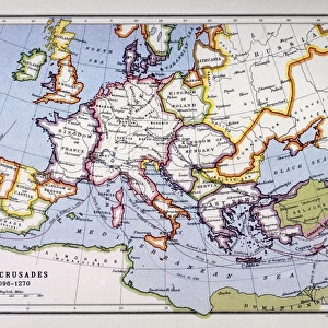
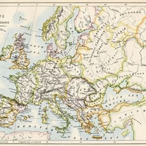
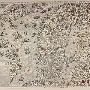
Map of Europe in the time of Charlemagne, 768-814 AD.
Printed color lithograph, 19th century
North Wind Picture Archives brings history to life with stock images and hand-colored illustrations
Media ID 5882669
© North Wind Picture Archives
700s 800s 8th Century 9th Century British Isles Empire Europe European France Great Britain Holy Roman Empire Medieval Mediterranean Sea Middle Ages North Sea Scandinavia Carolus Magnus Charlemagne Cordova
20"x16" (+3" Border) Fine Art Print
Step back in time with our exquisite selection from the Media Storehouse Fine Art Prints range. This captivating piece, PROY2A-00017 from North Wind Picture Archives, transports you to the European landscape of the 8th and 9th centuries during the reign of Charlemagne. Printed in vibrant color lithograph in the 19th century, this historical map offers a fascinating glimpse into the past. Add an air of sophistication and intrigue to your home or office decor with this stunning work of art.
20x16 image printed on 26x22 Fine Art Rag Paper with 3" (76mm) white border. Our Fine Art Prints are printed on 300gsm 100% acid free, PH neutral paper with archival properties. This printing method is used by museums and art collections to exhibit photographs and art reproductions.
Our fine art prints are high-quality prints made using a paper called Photo Rag. This 100% cotton rag fibre paper is known for its exceptional image sharpness, rich colors, and high level of detail, making it a popular choice for professional photographers and artists. Photo rag paper is our clear recommendation for a fine art paper print. If you can afford to spend more on a higher quality paper, then Photo Rag is our clear recommendation for a fine art paper print.
Estimated Image Size (if not cropped) is 50.8cm x 40.6cm (20" x 16")
Estimated Product Size is 66cm x 55.9cm (26" x 22")
These are individually made so all sizes are approximate
Artwork printed orientated as per the preview above, with landscape (horizontal) orientation to match the source image.
FEATURES IN THESE COLLECTIONS
> Animals
> Mammals
> Muridae
> Magnus
> Arts
> Art Movements
> Medieval Art
> Arts
> Artists
> R
> Roman Roman
> Historic
> Ancient civilizations
> Roman Empire
> Roman art
> Maps and Charts
> British Empire Maps
> Maps and Charts
> Related Images
> North Wind Picture Archives
> Maps
> North Wind Picture Archives
> Royals:rulers
EDITORS COMMENTS
This vintage print showcases a meticulously detailed map of Europe during the reign of Charlemagne, spanning from 768 to 814 AD. The stunning printed color lithograph, created in the 19th century by North Wind Picture Archives, transports us back to the medieval era with its rich historic significance. The illustration depicts an expansive view of Europe, stretching from the British Isles in the northwest to Cordova in the southwest and Slavia in the northeast. It beautifully captures key regions such as France and Scandinavia while highlighting significant bodies of water like the North Sea and Mediterranean Sea. At its center lies Charlemagne's vast empire, known as the Holy Roman Empire or Carolingian Empire. This powerful realm dominated much of Western Europe during this period and left an indelible mark on history. As we delve into this artful representation, we are transported through time to witness how kingdoms rose and fell within these borders. The map offers a glimpse into a world shaped by political alliances, cultural exchanges, and territorial conquests that defined European history throughout the Middle Ages. This remarkable piece serves not only as a visual delight but also as a valuable educational tool for understanding Europe's geopolitical landscape during one of its most influential periods.
MADE IN THE USA
Safe Shipping with 30 Day Money Back Guarantee
FREE PERSONALISATION*
We are proud to offer a range of customisation features including Personalised Captions, Color Filters and Picture Zoom Tools
SECURE PAYMENTS
We happily accept a wide range of payment options so you can pay for the things you need in the way that is most convenient for you
* Options may vary by product and licensing agreement. Zoomed Pictures can be adjusted in the Cart.