Fine Art Print : 16th Century Plan of Milan


![]()
Fine Art Prints from Science Photo Library
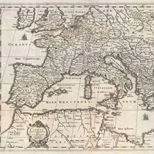
16th Century Plan of Milan
16th century plan of Milan. Details from the map of
Science Photo Library features Science and Medical images including photos and illustrations
Media ID 6320211
© Sheila Terry
16th Century Atlas Cartography Earth Science Gallery Of Maps Ignazio Danti Italian Italy Mapping Maps Milan Sciences Sixteenth Century 500s City Plan
20"x16" (+3" Border) Fine Art Print
Step back in time with our exquisite selection of Fine Art Prints from the Media Storehouse, featuring this stunning 16th Century Plan of Milan from Science Photo Library. Meticulously preserved, this intricately detailed map transports you to the heart of Italy during the Renaissance era. With its elaborate depiction of the city's fortifications, canals, and architectural landmarks, this print is a must-have for history enthusiasts and art lovers alike. Bring the rich history of Milan into your home or office and elevate your decor with this timeless piece.
20x16 image printed on 26x22 Fine Art Rag Paper with 3" (76mm) white border. Our Fine Art Prints are printed on 300gsm 100% acid free, PH neutral paper with archival properties. This printing method is used by museums and art collections to exhibit photographs and art reproductions.
Our fine art prints are high-quality prints made using a paper called Photo Rag. This 100% cotton rag fibre paper is known for its exceptional image sharpness, rich colors, and high level of detail, making it a popular choice for professional photographers and artists. Photo rag paper is our clear recommendation for a fine art paper print. If you can afford to spend more on a higher quality paper, then Photo Rag is our clear recommendation for a fine art paper print.
Estimated Image Size (if not cropped) is 50.8cm x 37cm (20" x 14.6")
Estimated Product Size is 66cm x 55.9cm (26" x 22")
These are individually made so all sizes are approximate
Artwork printed orientated as per the preview above, with landscape (horizontal) orientation to match the source image.
EDITORS COMMENTS
This print showcases a remarkable piece of history, the 16th Century Plan of Milan. With intricate details and stunning artistry, this map takes us back in time to explore the city's rich geographical and historical significance. As we delve into this Italian masterpiece, we are transported to Milan during the 1500s, where every street corner and building is meticulously illustrated. The map offers a fascinating glimpse into the city's layout, revealing its evolution over centuries. Created by Ignazio Danti, an esteemed cartographer of his time, this map exemplifies his mastery in capturing both artistic beauty and scientific accuracy. It serves as a testament to the importance of cartography in understanding our world. The 16th Century Plan of Milan not only provides valuable insights into urban planning but also sheds light on Italy's cultural heritage. This extraordinary piece belongs to the renowned Gallery of Maps at Vatican City—a treasure trove for history enthusiasts. Science Photo Library has expertly captured this rare gem with exceptional clarity and attention to detail. Through their lens, we can appreciate each stroke that brings life to ancient streets and landmarks. Whether you are an avid historian or simply captivated by old-world charm, this print invites you on an enchanting journey through time—an opportunity to marvel at Milan's past while appreciating the enduring legacy left behind by those who shaped it centuries ago.
MADE IN THE USA
Safe Shipping with 30 Day Money Back Guarantee
FREE PERSONALISATION*
We are proud to offer a range of customisation features including Personalised Captions, Color Filters and Picture Zoom Tools
SECURE PAYMENTS
We happily accept a wide range of payment options so you can pay for the things you need in the way that is most convenient for you
* Options may vary by product and licensing agreement. Zoomed Pictures can be adjusted in the Cart.