Fine Art Print > STEAM Museum of the GWR > Artwork and documents > Maps & Plans
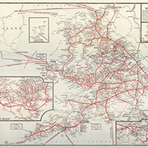
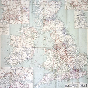
Fine Art Print : British Railways network map 1950s


![]()
Fine Art Prints from STEAM Museum
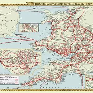
British Railways network map 1950s
A map showing the rail lines across the British Railway network during the 1950s
STEAM - Museum of the Great Western Railway
Media ID 20350523
© STEAM Picture Library
British Railways Network Routes
20"x16" (+3" Border) Fine Art Print
Step back in time with our exquisite Fine Art Print from Media Storehouse's Steam Museum of the GWR collection. This captivating image showcases the British Railways network map from the 1950s, a period of rich railway history. The intricate details of the rail lines crisscrossing the map transport you to an era of steam trains, nostalgia, and adventure. Hang this beautiful print in your home or office to add a touch of vintage charm and evoke the spirit of a bygone era. A must-have for railway enthusiasts and history buffs alike.
20x16 image printed on 26x22 Fine Art Rag Paper with 3" (76mm) white border. Our Fine Art Prints are printed on 300gsm 100% acid free, PH neutral paper with archival properties. This printing method is used by museums and art collections to exhibit photographs and art reproductions.
Our fine art prints are high-quality prints made using a paper called Photo Rag. This 100% cotton rag fibre paper is known for its exceptional image sharpness, rich colors, and high level of detail, making it a popular choice for professional photographers and artists. Photo rag paper is our clear recommendation for a fine art paper print. If you can afford to spend more on a higher quality paper, then Photo Rag is our clear recommendation for a fine art paper print.
Estimated Image Size (if not cropped) is 37cm x 50.8cm (14.6" x 20")
Estimated Product Size is 55.9cm x 66cm (22" x 26")
These are individually made so all sizes are approximate
Artwork printed orientated as per the preview above, with portrait (vertical) orientation to match the source image.
EDITORS COMMENTS
This print showcases the intricate and expansive British Railways network map from the 1950s, a true testament to the golden age of rail travel. With its vibrant colors and meticulous detailing, this map offers a fascinating glimpse into the extensive web of rail lines that crisscrossed across the United Kingdom during this era.
The British Railways network map is not just an ordinary depiction of routes; it represents a vital lifeline connecting towns, cities, and communities throughout Britain. It serves as a visual reminder of how railways played an integral role in shaping transportation infrastructure during this transformative period.
As one gazes upon this remarkable piece, they are transported back in time to an era when steam locomotives ruled the tracks. The carefully illustrated lines depict major railway hubs such as London, Manchester, Edinburgh, and Cardiff while also highlighting lesser-known stations nestled amidst picturesque landscapes.
Beyond its aesthetic appeal lies historical significance. This map captures a moment in history when British Railways was at its peak before undergoing significant changes later on. It symbolizes progress and innovation while embodying nostalgia for those who experienced train travel during these halcyon days.
Preserved within STEAM Museum of the GWR's collection, this print stands as a tribute to both our rich railway heritage and our ongoing fascination with transport networks. Whether you are an avid historian or simply captivated by vintage aesthetics, this image invites you to explore Britain's past through its vast rail connections – each line representing countless journeys taken by millions over decades gone by.
MADE IN THE USA
Safe Shipping with 30 Day Money Back Guarantee
FREE PERSONALISATION*
We are proud to offer a range of customisation features including Personalised Captions, Color Filters and Picture Zoom Tools
SECURE PAYMENTS
We happily accept a wide range of payment options so you can pay for the things you need in the way that is most convenient for you
* Options may vary by product and licensing agreement. Zoomed Pictures can be adjusted in the Cart.