Photo Mug > STEAM Museum of the GWR > Artwork and documents > Maps & Plans
Photo Mug : British Railways network map 1950s


![]()
Home Decor from STEAM Museum
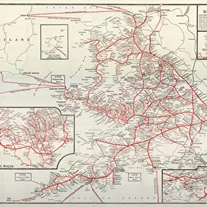
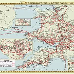
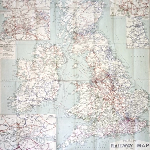
British Railways network map 1950s
A map showing the rail lines across the British Railway network during the 1950s
STEAM - Museum of the Great Western Railway
Media ID 20350523
© STEAM Picture Library
British Railways Network Routes
Large Photo Mug (15 oz)
Introducing the Media Storehouse Photo Mug, a perfect blend of nostalgia and functionality. This mug features an iconic British Railways network map from the STEAM Museum of the GWR, transporting you back to the 1950s with every sip. Relive the golden age of rail travel as you enjoy your favorite beverage from this beautifully designed mug. The high-quality image ensures vibrant colors and fine details, making it a must-have for railway enthusiasts and history buffs alike. Embrace the past, savor the present, and make your morning routine a journey with our Photo Mug.
Elevate your coffee or tea experience with our premium white ceramic mug. Its wide, comfortable handle makes drinking easy, and you can rely on it to be both microwave and dishwasher safe. Sold in single units, preview may show both sides of the same mug so you can see how the picture wraps around.
Elevate your coffee or tea experience with our premium white ceramic mug. Its wide, comfortable handle makes drinking easy, and you can rely on it to be both microwave and dishwasher safe. Sold in single units, preview may show both sides of the same mug so you can see how the picture wraps around.
These are individually made so all sizes are approximate
EDITORS COMMENTS
This print showcases the intricate and expansive British Railways network map from the 1950s, a true testament to the golden age of rail travel. With its vibrant colors and meticulous detailing, this map offers a fascinating glimpse into the extensive web of rail lines that crisscrossed across the United Kingdom during this era.
The British Railways network map is not just an ordinary depiction of routes; it represents a vital lifeline connecting towns, cities, and communities throughout Britain. It serves as a visual reminder of how railways played an integral role in shaping transportation infrastructure during this transformative period.
As one gazes upon this remarkable piece, they are transported back in time to an era when steam locomotives ruled the tracks. The carefully illustrated lines depict major railway hubs such as London, Manchester, Edinburgh, and Cardiff while also highlighting lesser-known stations nestled amidst picturesque landscapes.
Beyond its aesthetic appeal lies historical significance. This map captures a moment in history when British Railways was at its peak before undergoing significant changes later on. It symbolizes progress and innovation while embodying nostalgia for those who experienced train travel during these halcyon days.
Preserved within STEAM Museum of the GWR's collection, this print stands as a tribute to both our rich railway heritage and our ongoing fascination with transport networks. Whether you are an avid historian or simply captivated by vintage aesthetics, this image invites you to explore Britain's past through its vast rail connections – each line representing countless journeys taken by millions over decades gone by.
MADE IN THE USA
Safe Shipping with 30 Day Money Back Guarantee
FREE PERSONALISATION*
We are proud to offer a range of customisation features including Personalised Captions, Color Filters and Picture Zoom Tools
SECURE PAYMENTS
We happily accept a wide range of payment options so you can pay for the things you need in the way that is most convenient for you
* Options may vary by product and licensing agreement. Zoomed Pictures can be adjusted in the Cart.